
The San Francisco Peninsula is a peninsula in the San Francisco Bay Area that separates San Francisco Bay from the Pacific Ocean. On its northern tip is the City and County of San Francisco. Its southern base is Los Altos, Mountain View, in Santa Clara County, south of Palo Alto and north of Sunnyvale and Los Altos. Most of the Peninsula is occupied by San Mateo County, between San Francisco and Santa Clara counties, and including the cities and towns of Atherton, Belmont, Brisbane, Burlingame, Colma, Daly City, East Palo Alto, El Granada, Foster City, Half Moon Bay, Hillsborough, La Honda, Loma Mar, Los Altos, Los Altos Hills, Menlo Park, Millbrae, Mountain View, Pacifica, Palo Alto, Pescadero, Portola Valley, Redwood City, Redwood Shores, San Bruno, San Carlos, San Mateo, South San Francisco, Sunnyvale, West Menlo Park and Woodside.

U.S. Route 101, or U.S. Highway 101 (US 101), is a north–south highway that traverses the states of California, Oregon, and Washington on the West Coast of the United States. It is part of the United States Numbered Highway System and runs for over 1,500 miles (2,400 km) along the Pacific Ocean. The highway is also known by various names, including El Camino Real in parts of California, the Oregon Coast Highway, and the Olympic Highway in Washington. Despite its three-digit number, normally used for spur routes, US 101 is classified as a primary route.

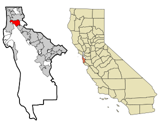
San Mateo County, officially the County of San Mateo, is a county in the U.S. state of California. As of the 2020 census, the population was 764,442. Redwood City is the county seat, the third-most populated city in the county after Daly City and San Mateo.

Millbrae is a city located in northern San Mateo County, California, United States. To the northeast is San Francisco International Airport; San Bruno is to the northwest, and Burlingame is to the southeast. It is bordered by San Andreas Lake to the southwest. The population was 23,216 at the 2020 census.
San Bruno is a city in San Mateo County, California, United States, incorporated in 1914. The population was 43,908 at the 2020 United States Census. The city is between South San Francisco and Millbrae, adjacent to San Francisco International Airport and Golden Gate National Cemetery; it is approximately 12 miles (19 km) south of Downtown San Francisco.

El Camino Real is a 600-mile (965-kilometer) commemorative route connecting the 21 Spanish missions in California, along with a number of sub-missions, four presidios, and three pueblos. Historically associated with a network of royal roads used by inhabitants of New Spain, the modern commemorative route in the U.S. state of California is named after these roads, with its southern terminus at Mission San Diego de Alcalá and its northern terminus at Mission San Francisco Solano in Sonoma.

Interstate 380 (I-380) is a short 3.3-mile (5.3 km) east–west auxiliary Interstate Highway in the San Francisco Bay Area of Northern California, connecting I-280 in San Bruno to US Route 101 (US 101) near San Francisco International Airport. The highway primarily consists of only three intersections: I-280, State Route 82, and US 101. Like the nearby I-280, I-380 never connects to I-80, its parent Interstate Highway. However, there is no rule that says that spur routes need to do so.

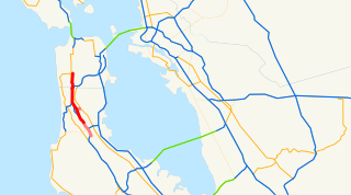
The Bayshore Freeway is a part of U.S. Route 101 in the San Francisco Bay Area of the U.S. state of California. It runs along the west shore of the San Francisco Bay, connecting San Jose with San Francisco. Within the city of San Francisco, the freeway is also known as James Lick Freeway, named after the California philanthropist. The road was originally built as a surface road, the Bayshore Highway, and later upgraded to freeway standards. Before 1964, it was mostly marked as U.S. Route 101 Bypass, with US 101 using the present State Route 82.

State Route 82 is a state highway in the U.S. state of California that runs from Interstate 880 (I-880) in San Jose to I-280 in San Francisco following the San Francisco Peninsula. It is the spinal arterial road of the peninsula and runs parallel to the nearby Caltrain line along much of the route. For much of its length, the highway is named El Camino Real and formed part of the historic El Camino Real mission trail. It passes through and near the historic downtowns of many Peninsula cities, including Burlingame, San Mateo, Redwood City, Menlo Park, Palo Alto, Mountain View, Sunnyvale, and Santa Clara, and through some of the most walkable and transit-oriented neighborhoods in the region.

Colma station is a Bay Area Rapid Transit (BART) station located in unincorporated northern San Mateo County, California adjacent to the incorporated town of Colma and city of Daly City. The station is served by the Red and Yellow lines. Colma station is situated in a small valley shared with BART's Daly City Yard and a large parking garage. The station has three tracks, with an island platform between the two eastern tracks and a side platform next to the western track. Only the two eastern tracks are used for revenue service.

Millbrae station is an intermodal transit station serving Bay Area Rapid Transit (BART) and Caltrain, located in Millbrae, California. The station is the terminal station for BART on the San Francisco Peninsula, served by two lines: The Red Line before 9 pm and the Yellow Line during the early morning and evening. It is served by all Caltrain services. The station is also served by SamTrans bus service, Commute.org and Caltrain shuttle buses, and other shuttles.
U.S. Route 101 (US 101) is a major north–south United States Numbered Highway, stretching from Los Angeles, California, to Tumwater, Washington. The California portion of US 101 is one of the last remaining and longest U.S. Routes still active in the state, and the longest highway of any kind in California. US 101 was also one of the original national routes established in 1926. Significant portions of US 101 between the Los Angeles area and the San Francisco Bay Area follow El Camino Real, the commemorative route connecting the former Alta California's 21 missions.
Sierra Highway or El Camino Sierra is a road in Southern California, United States. El Camino Sierra refers to the full length of a trail formed in the 19th century, rebuilt as highways in the early 20th century, that ran from Los Angeles to Lake Tahoe following parts of modern State Route 14, U.S. Route 395 and State Route 89. Two portions of this road are currently signed as Sierra Highway. The first is an old alignment of SR 14/U.S. Route 6 from Los Angeles to Mojave. This road is also signed with the unusual designation of State Route 14U through the city of Santa Clarita. The second part signed as Sierra Highway is a portion of US 395 in Bishop.

The Peninsular Railway was an interurban electrified railway in the U.S. State of California in the United States of America. It served the area between San Jose, Los Gatos, and Palo Alto, comprising much of what is today known as "Silicon Valley". For much of its existence it was a subsidiary of the Southern Pacific Railroad.
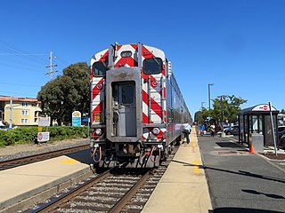
Broadway station is a Caltrain station in Burlingame, California. Caltrain only serves the stop on weekends and holidays; weekday service is provided by a bus shuttle to nearby Millbrae station.

The Spur Trail is a paved walking trail in San Mateo County, California, south of San Francisco. It is located in Millbrae on Spur Property parkland. The pathway consists of two disjointed sections; one is located to the west of Taylor Middle School and the other is located north of Mills High School. The trail and its associated park is an important recreational opportunity for local residents.
Junipero Serra Boulevard is a major boulevard in and south of San Francisco named after Franciscan friar Junipero Serra. Within the city, it forms part of the route of State Route 1, the shortest connection between Interstate 280 and the Golden Gate Bridge. The remainder, in San Mateo County, was bypassed or replaced by I-280, the Junipero Serra Freeway. The boulevard was one of several new roads built along the San Francisco Peninsula before the age of freeways, and became a state highway known as Route 237 in 1956, receiving the State Route 117 designation in the 1964 renumbering, only to be deleted from the state highway system the next year. Two other regional highways—Bayshore Highway and Skyline Boulevard—were also upgraded into or bypassed by freeways.
Rancho Buri Buri was a 14,639-acre (59.24 km2) Mexican land grant in present-day San Mateo County, California, given in 1835 by Governor José Castro to José Antonio Sánchez. The name derives from the Urebure village of the Ramaytush speaking Yelamu tribe of Ohlone people who were settled by the banks of San Bruno Creek. Rancho Buri Buri extended between the north line of South San Francisco and the middle of Burlingame, and from the San Francisco Bay to the top of the Peninsula ridge and included present-day Lomita Park, Millbrae, South San Francisco, San Bruno, and the northern part of Burlingame.
Peninsula Mile Houses began to be opened, in 1849, with the organisation of a stagecoach line service connecting San Francisco and San Jose, California. They served as stagecoach stop locations for transfer, rest, and refreshment, for travelers and horses, on the rough journey that spanned at least nine hours from San Francisco to San Jose.
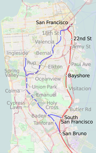
The Ocean View Branch was a railroad line between San Francisco and San Bruno, California. It was in use from 1863 to 1942, with some sections remaining until the 1970s. Its importance as a rail corridor was greatly reduced after the 1907 opening of the flatter and shorter Bayshore Cutoff. The right-of-way between Glen Park and San Bruno was reused for Interstate 280 and Bay Area Rapid Transit.


