This article needs additional citations for verification .(April 2021) |
Sky Londa | |
---|---|
Coordinates: 37°23′1″N122°15′42″W / 37.38361°N 122.26167°W Coordinates: 37°23′1″N122°15′42″W / 37.38361°N 122.26167°W | |
Country | United States |
State | California |
County | San Mateo |
Elevation | 1,520 ft (460 m) |
Time zone | UTC-8 (Pacific (PST)) |
• Summer (DST) | UTC-7 (PDT) |
ZIP codes | 94062 |
Area code | 650 |
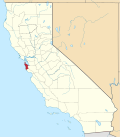
Sky Londa is an unincorporated mountain community in San Mateo County, California located at the intersection of State Route 84 (La Honda Road) and State Route 35 (Skyline Boulevard). The community is inside area code 650 and ZIP code 94062.
Atop the coastal range west of Woodside, the community's official elevation is 1,520 feet (463 m) above mean sea level (AMSL). [1]
While Sky Londa is the spelling approved by the U.S. Board of Geographic Names, a frequently used state government variant spelling is Skylonda. The variant spelling is used on a Caltrans sign for southbound SR35 north of SR84 and on the name of a CDF Fire station in the community. This variant name is also shown as a variant in the National Geographic Names Database. The 1994 USGS 7.5-minute quadrangle, Woodside, California shows it spelled Sky Londa. [2] Maps recorded as early as 1909 show it as Sky L'onda apparently derived from the crossroad names Skyline Boulevard and Woodside-La Honda Road.
The 7.5-minute quadrangle, Woodside, California, (1994), shows Woodside VOR north of the settlement. The aircraft navigation facility is shown as being outfitted with distance measuring equipment. It lies one mile (1.6 km) at 285 degrees off true north from the intersection of SR35 and SR84. Its identifier is "OSI" and publicly available FAA documents show the VOR signal is on 113.9 MHz.
Many of the area's characteristic redwood-log homes were first built in the early 1930s by a developer who subdivided a few tracts and established a water supply and reservoirs dedicated to the new community. The redwood "logs" came from unused railroad-tie stock sawn by a mill located at the intersection until the Depression. The local water is still pumped from wells and La Honda Creek, and delivered to 154 homes by the Sky L'onda Mutual Water Company. [3]
There are a few commercial establishments at the intersection of SR35 and SR84, including two service stations, a convenience store, a real estate office, a small events center, and Alice's Restaurant. Once a general store, and the first commercial building in Sky Londa, [4] during the 1960’s the restaurant was bought by one Alice Taylor, who renamed the restaurant after herself. The relationship to the restaurant of Arlo Guthrie's Vietnam War protest song is only in hindsight. [5] [6] Already a renowned stop for motorcyclists, hikers and tourists, Alice’s Restaurant (and the adjacent buildings) was bought in the 1970’s and has been family owned & operated ever since.
The area is a popular destination for motorcycle and bicycle riders, especially during spring and summer weekends.
The San Francisco Peninsula is a peninsula in the San Francisco Bay Area that separates San Francisco Bay from the Pacific Ocean. On its northern tip is the City and County of San Francisco. Its southern base is in northern Santa Clara County, including the cities of Sunnyvale, Palo Alto, Mountain View, and Los Altos. Most of the Peninsula is occupied by San Mateo County, between San Francisco and Santa Clara counties, and including the cities and towns of Atherton, Belmont, Brisbane, Burlingame, Colma, Daly City, East Palo Alto, El Granada, Foster City, Hillsborough, Half Moon Bay, La Honda, Loma Mar, Los Altos, Menlo Park, Millbrae, Mountain View, Pacifica, Palo Alto, Pescadero, Portola Valley, Redwood City, San Bruno, San Carlos, San Mateo, South San Francisco, Sunnyvale, and Woodside.
San Mateo County, officially the County of San Mateo, is a county located in the U.S. state of California. As of the 2020 census, the population was 764,442. Redwood City is the county seat, and the third most populated city following Daly City and San Mateo. San Mateo County is included in the San Francisco-Oakland-Berkeley, CA MSA, Silicon Valley, and is part of the San Francisco Bay Area, the nine counties bordering San Francisco Bay. It covers most of the San Francisco Peninsula. San Francisco International Airport is located in the northeastern area of the county and is approximately 7 miles south of the city and county limits of San Francisco, even though the airport itself is assigned a San Francisco postal address. The county's built-up areas are mostly suburban, and are home to several corporate campuses.
Woodside is a small incorporated town in San Mateo County, California, United States, on the San Francisco Peninsula. Woodside is among the wealthiest communities in the United States, home to many technology billionaires and investment managers, with average home prices exceeding 5 million dollars. It has a council–manager system of government. The population of the town was 5,309 at the 2020 census.
The Santa Cruz Mountains, part of the Pacific Coast Ranges, are a mountain range in central and Northern California, United States. They form a ridge down the San Francisco Peninsula, south of San Francisco. They separate the Pacific Ocean from the San Francisco Bay and the Santa Clara Valley, and continue south to the Central Coast, bordering Monterey Bay and ending at the Salinas Valley. The range passes through the counties of San Mateo, Santa Clara, Santa Cruz, San Benito and Monterey, with the Pajaro River forming the southern boundary.
Stovepipe Wells is a way-station in the northern part of Death Valley, in unincorporated Inyo County, California.
Big Basin Redwoods State Park is a state park in the U.S. state of California, located in Santa Cruz County, about 36 km (22 mi) northwest of Santa Cruz. The park contains almost all of the Waddell Creek watershed, which was formed by the seismic uplift of its rim, and the erosion of its center by the many streams in its bowl-shaped depression.
Area code 650 is a telephone area code in the North American Numbering Plan (NANP) for the San Francisco Bay Area in the U.S. state of California. It was split from area code 415 on August 2, 1997, and includes most of San Mateo County, part of San Francisco, and the northwestern portion of Santa Clara County including Palo Alto, Mountain View, and Los Altos.
The Skyline-to-the-Sea Trail is a 29.5-mile (47.2-kilometre) hiking trail that descends from the ridge of the Santa Cruz Mountains in California to the Pacific Ocean, passing through Castle Rock State Park and Big Basin Redwoods State Park. Big Basin is California's oldest state park. It contains beautiful waterfalls and some of the largest, tallest, and oldest Redwood forests left in existence.
State Route 9 is a rural and mountainous state highway in the U.S. state of California that travels 35 miles (56 km) from SR 1 in Santa Cruz to SR 17 in Los Gatos, passing through the San Lorenzo Valley and the Saratoga Gap in the Santa Cruz Mountains.
State Route 35, generally known as Skyline Boulevard for most of its length, is a mostly two-lane state highway in the U.S. state of California. It runs along the ridge of the Santa Cruz Mountains from the high point of State Route 17 near Lexington Reservoir in Santa Clara County to State Route 1 just south of Daly City in San Mateo County, where it crosses SR 1 and loops around Lake Merced to become Sloat Boulevard in San Francisco. SR 35 then continues along Sloat Boulevard until it reaches its terminus when it meets SR 1 again at 19th Avenue.
State Route 84 is a state highway in the U.S. state of California that consists of two unconnected segments, one in the San Francisco Bay Area and the other primarily in the Sacramento–San Joaquin River Delta area.
A tourist trap is an establishment that has been created or re-purposed with the aim of attracting tourists and their money. Tourist traps will typically provide overpriced services, entertainment, food, souvenirs and other products for tourists to purchase. Tourist trap derives from the information asymmetry between tourists and the market.
Skeggs Point is a scenic turnout in San Mateo County along State Route 35 between Kings Mountain and State Route 84. The feature is marked with a guide sign along the road and is listed on the USGS 7.5 minute quadrangle, "Woodside, California" as well as in the National Geographic Names Database. The area is about three miles west and 2,000 feet above the town of Woodside.
Middleton Tract is a rural community in the coastal Redwoods of San Mateo County, California. Unattributed press reports say the name Middleton Tract may have been applied to this area as early as 1925. In the present day, the name is official at the county government level. It appears on County Assessor's maps including County of San Mateo, Master Index Map, Revision 2, June, 1985,, page 40–41.
Kings Mountain is an unincorporated community in San Mateo County, California, located along State Route 35 between Skeggs Point and Pise Mountain. This is about seven miles (11 km) north of Woodside Road (SR84). In the U.S. Geological Survey, National Geographic Names Database, the area is identified only as a geographic feature of type "summit" and not as a populated place. The community is inside area code 650 and uses the Woodside ZIP Code 94062.
Ocotillo Wells is an unincorporated community in San Diego County, California, United States. It is 3 miles (4.8 km) west of the Imperial County line on California State Route 78 at an elevation of 163 feet (50 m). The name became official in 1962 when it was adopted for federal use by the US Board on Geographic Names. A federally recognized variant name, Ocotillo, can cause confusion with the community of Ocotillo, California in Imperial County, 29 mi (47 km) to the south on Interstate 8.
San Gregorio Creek is a river in San Mateo County, California. Its tributaries originate on the western ridges of the Santa Cruz Mountains whence it courses southwest through steep forested canyons. The San Gregorio Creek mainstem begins at the confluence of Alpine and La Honda Creeks, whence it flows 12 miles (19 km) through rolling grasslands and pasturelands until it meets the Pacific Ocean at San Gregorio State Beach. It traverses the small unincorporated communities of La Honda, San Gregorio, Redwood Terrace and Sky Londa.
La Honda Creek is a small river in San Mateo County, California and is a tributary of San Gregorio Creek. It flows about 7 miles (11 km), from its source near Bear Gulch Road and Skyline Boulevard (CA 35), to its confluence with Alpine Creek to form San Gregorio Creek in La Honda.
Martin Creek, known locally as Dennis Martin Creek, is a 1.4-mile-long (2.3 km) north by northeastward-flowing stream originating just east of Skyline Boulevard in the Santa Cruz Mountains, near the community of Skylonda in San Mateo County, California. It flows through the town of Woodside before joining Sausal Creek on Stanford University lands just across the border from Woodside. Sausal Creek enters Searsville Reservoir, which flows to San Francisco Bay via San Francisquito Creek.
Alambique Creek, or Arroyo Alembique, is a 2.7-mile-long (4.3 km) stream located in San Mateo County, California in the United States. It is part of the San Francisquito Creek watershed.