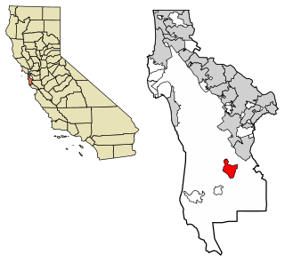
Middleton Tract is a rural community in the coastal Redwoods of San Mateo County, California. Unattributed press reports say the name Middleton Tract may have been applied to this area as early as 1925. In the present day, the name is official at the county government level. It appears on County Assessor's maps including County of San Mateo, Master Index Map, Revision 2, June, 1985, (Redwood City, California: County of San Mateo Assessor), page 40-41.
The community is east of Portola Park Road generally between Middleton Tract Road and Slate Creek Road. While the 1997 version of the Mindego Hill 7.5 minute quadrangle does not show Middleton Tract Road, it diverges east from Portola Park Road at a location called Crockers Curve (USGS feature ID 221842, NAD27 coordinates) 37°16′13″N122°12′37″W / 37.27028°N 122.21028°W / 37.27028; -122.21028. There are about two dozen mail boxes on the west side of Portola Park Road at this location. The intersection of Slate Creek Road and Portola Park Road is located approximately at latitude and longitude 37°15′57″N122°12′35″W / 37.26583°N 122.20972°W / 37.26583; -122.20972 (NAD27). This is just outside the entrance station for Portola State Park.
Oil Creek Oil Field is east of the area.
A geographic feature, San Mateo County Fire Department Station 54 – also known as Middleton Tract according to the County of San Mateo's web site – supports this name as being official. Some of the roads and the fire station are shown on commercial maps such as Thomas Brothers Guides but the name Middleton Tract is not identified. The South Skyline Historical Society also cites this name in describing the area.
Middleton Tract was purchased by William Middleton sometime prior to 1923. Middleton received title to the great expanse of land (approximately 640 acres (2.6km2) or one "section") by way of several deeds. The tract is legally described as: the northeast quarter of section 5; the east half of the southeast quarter of section 5; the west half of section 4; all in township 8 south, range 3 west, M.D.B. & M.
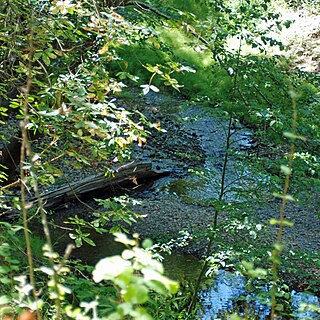
During the late 1880s portions of the land now known as the "Middleton Trac" were logged and the logs processed at the "Old Page Mill" site which is now located within Portola State Park. However much of the logging was perfunctory and many stands of old growth redwoods remained within the quarter section, including some very large trees in the Peters Creek drainage, and in several steep canyon areas. Some of these old growth trees exceed 40-foot (12m) diameters at the base. Second growth trees soon sprouted from the logged stumps and today stand as very large trees many exceeding ten foot diameters at the base.
The Middleton Tract was subdivided according to a plan created by Middleton and parcels were sold for summer residences. Included in Middleton's plan of development was a prohibition on logging and hunting.
During the late 1920s and through the early 1950s a number of parcels were purchased by Stanford University luminaries and summer "cabins" were constructed. Among the owners of homes in the Middleton Tract was Frederick Terman. Terman founded the "towers of excellence" academic strategy that led Stanford to a leading role in engineering and electronics. J. Wallace Sterling, President of Stanford University from 1949 to 1968 built a rustic log cabin within the Middleton Tract as well as several university professors. Descendants of President Herbert Hoover also constructed several summer cabins within the tract. During the 1970s many of these summer homes became full-time residences and continue as full-time residences to this day. William Middleton died in 1962.
While the 640 acres (2.6km2) was subdivided according to Middleton's plan into 80 parcels, many of the parcels, particularly those to the south and those on steep slopes remained undeveloped.
Many of the undeveloped parcels were acquired by the Holmes Lumber Company in Santa Cruz County. Approximately 150 acres (0.61km2) were purchased and in 1986 Holmes Lumber applied for and received a "Timber Harvesting Permit" from the California State Board of Forestry allowing commercial logging activities on the property
Many residents of the Middleton Tract, fearing the devastation of logging within their peaceful rural community formed the Greater Middleton Association(GMA)and proceed to file a lawsuit to enforce Middleton's Covenants, Conditions, and Restrictions (CC&R's) reflected within the deeds to the parcels. Residents of the Middleton Tract Laura: A. Bryan, Timothy G. Geiser, and Malcolm McGilvray, Jr., were responsible for forming the GMA
After a lengthy court trial in Superior Court of San Mateo County, Presiding JudgeFrank Piombo ruled in favor of the GMA and enforced the CC&R's. Holmes Lumber was permanently enjoined from logging activity within the Middleton Tract.
Holmes Lumber Company appealed the lower court decision, but the Appellate Court upheld the lower courts decision as did the Supreme Court of the State of California. The commercial logging ban, under the legal concept of enforceable "equitable servitude" was upheld. An "equitable servitude" is a term used in the law of real property to describe a nonposseessory interest in land that operates much like a covenant running with the land.
The case may be found at "Greater Middleton Assn. v. Holmes Lumber Co.(1990) 222 Cal.App.3d 980 , 271 Cal.Rptr. 917" and was one of the first legal decisions concerning "equitable servitudes" in the past 70 years. This case is frequently sited in both California court decisions and in other states as well. Much of the history of the Middleton Tract can be found within the court filings of both litigants.
San Mateo County, officially the County of San Mateo, is a county located in the U.S. state of California. As of the 2010 census, the population was 718,451. The county seat is Redwood City.
Año Nuevo State Park is a state park of California, USA, encompassing Año Nuevo Island and Año Nuevo Point, which are known for their pinniped rookeries. Located in San Mateo County, the low, rocky, windswept point juts out into the Pacific Ocean about 55 miles (89 km) south of San Francisco and the Golden Gate. Año Nuevo State Natural Reserve, formerly a separate unit of the California state park system, was merged into Año Nuevo State Park in October 2008. The coastal geographic center, or coastal-midpoint of California is located at the Northern end of this park at N 37°09′58″, W 122°21'40", as the absolute geographic center of California falls at N 37°09′58″, W 119°26′58″W.
La Honda is a census-designated place (CDP) in southern San Mateo County, California, United States. The population was 928 at the 2010 census. It is located in the Santa Cruz Mountains between the Santa Clara Valley and the Pacific coast of California. La Honda is near the La Honda Creek Open Space Preserve and State Route 84 on the ocean side of the Coastal Range. La Honda is derived from Spanish meaning "the sling".
Area code 650 is a telephone area code in the North American Numbering Plan (NANP) for the San Francisco Bay Area in the U.S. state of California. It was split from area code 415 on August 2, 1997, and includes most of San Mateo County, part of San Francisco, and the northwestern portion of Santa Clara County including Palo Alto, Mountain View, and Los Altos.
Portola Redwoods State Park is a California state park, located in San Mateo County. Peters Creek and Pescadero Creek meet in Portola, and are the park's primary watercourses, and feature numerous tributaries. Tip Toe Falls is a small waterfall along Fall Creek, a tributary of Pescadero Creek.
Montclair is a neighborhood in Oakland, California, United States. Montclair is located along the western slope of the Oakland Hills from a valley formed by the Hayward Fault to the upper ridge of the hills.
Los Trancos Woods is an unincorporated community in San Mateo County, California near the border of Santa Clara County. The US Geological Survey, National Geographic Names Database, show it as a feature type populated place. The area does not have its own unique ZIP code; it is in ZIP code 94028 and area code 650. The community adjoins the City of Palo Alto's Foothills Park. It is on the US Geological Survey's 7.5-minute "Mindego Hill" quadrangle. Coordinates in the National Geographic Names Database are shown as 37°20′58″N122°11′58″W. County documents suggest the community may eventually be annexed by Portola Valley.
Kings Mountain is an unincorporated community in San Mateo County, California, located along State Route 35 between Skeggs Point and Pise Mountain. This is about seven miles (11 km) north of Woodside Road (SR84). In the U.S. Geological Survey, National Geographic Names Database, the area is identified only as a geographic feature of type "summit" and not as a populated place. The community is inside area code 650 and uses the Woodside ZIP Code 94062.
Sky Londa is an unincorporated mountain community in San Mateo County, California located at the intersection of State Route 84 and State Route 35. The community is inside area code 650 and ZIP code 94062.
San Mateo Creek is a perennial stream whose watershed includes Crystal Springs Reservoir, for which it is the only natural outlet after passing Crystal Springs Dam.
Pescadero Creek is a major stream in Santa Cruz and San Mateo counties in California. At 26.6 miles (42.8 km), it is the longest stream in San Mateo County and flows all year from springs in the Santa Cruz Mountains. Its source is at 1,880 feet (570 m) above sea level on the western edge of Castle Rock State Park, with additional headwaters in Portola Redwoods State Park, and its course traverses Pescadero Creek County Park and San Mateo County Memorial Park before entering Pescadero Marsh Natural Preserve at Pescadero State Beach and thence to the Pacific Ocean 14.4 miles (23 km) south of Half Moon Bay.
Iverson Creek is a small river in San Mateo County, California and is a tributary of Pescadero Creek. It flows about 0.6 miles (1 km) from its source on Butano Ridge in Pescadero Creek County Park to its mouth in Portola Redwoods State Park.
San Mateo County's Memorial Park is located in Loma Mar and is operated by the San Mateo County Department of Parks. The park encompasses 673 acres (2.72 km2), and includes old-growth redwood trees, eight miles (13 km) of hiking trails, camping areas, picnic facilities, a visitor center, a camp store, a creek swimming area, and campfire programs. Pescadero Creek, which provides winter habitat for steelhead trout, runs through the park. Bloomquist, Hoffman, McCormick, and Peterson Creeks join Pescadero Creek within the park boundaries.
Alma is a ghost town and drowned town in Santa Clara County in California, United States. It lies beneath the waters of the Lexington Reservoir above Los Gatos. The location is latitude 37.18N and longitude 121.98W. It was 551 feet above sea level.
The Phleger Estate is a park in San Mateo County, California. The park is located outside the town of Woodside and adjacent to Huddart County Park. The park was acquired in 1991 by the Peninsula Open Space Trust (POST) for $25 million and is now part of the Golden Gate National Recreation Area (GGNRA).
Bear Creek, or Bear Gulch Creek, is a 6.6-mile-long (10.6 km) southeastward-flowing stream originating north of the summit of Sierra Morena in the Santa Cruz Mountains, near the community of Kings Mountain in San Mateo County, California, United States. It flows through the town of Woodside. Bear Creek and Corte Madera Creek join to become San Francisquito Creek in the Jasper Ridge Biological Preserve at Stanford University.
The Peninsula Library System (PLS) is a consortium of public and community college libraries in San Mateo County, California, United States, which serves the part of the San Francisco Bay Area known as "The Peninsula". The system has dozens of branches in local communities and at various area community colleges, a bookmobile, and automated book kiosks called Library-a-Go-Go.
Laguna Creek is a perennial stream that flows northwesterly for 2.6-mile (4.2 km) along the San Andreas Fault from Woodside in San Mateo County, California and, after crossing the Phleger Estate and Filoli, enters Upper Crystal Springs Reservoir, where it is a historic tributary to San Mateo Creek. San Mateo Creek then carries its waters over Crystal Springs Dam northeast to San Francisco Bay.
San Mateo County's Pescadero Creek Park is located near Loma Mar and is operated by the San Mateo County Department of Parks. The park complex of 8,020 acres (32.5 km2) also includes the neighboring Memorial, Sam McDonald and Heritage Grove parks. The park borders Portola Redwoods State Park with seamless trails, and connects to Big Basin Redwoods State Park via a trail easement across private lands.
San Mateo County's Sam McDonald Park is located between La Honda and Loma Mar and is operated by the San Mateo County Department of Parks. The park is 867 acres (3.51 km2) of redwood forest, mixed woods and open meadows. Trails climb up to a ridgeline with views across the Pescadero Creek valley, Butano Ridge, and the Pacific Ocean. The park includes Heritage Grove and borders Pescadero Creek County Park through which it connects to Memorial County Park, Portola Redwoods State Park, and Big Basin Redwoods State Park. Horseback riding is popular here, and many use Jack Brook Horse Camp.
This page is based on this Wikipedia article Text is available under the CC BY-SA 4.0 license; additional terms may apply. Images, videos and audio are available under their respective licenses.