
The San Francisco Peninsula is a peninsula in the San Francisco Bay Area that separates San Francisco Bay from the Pacific Ocean. On its northern tip is the City and County of San Francisco. Its southern base is in northern Santa Clara County, including the cities of Palo Alto, Mountain View, and Los Altos. Most of the Peninsula is occupied by San Mateo County, between San Francisco and Santa Clara counties, and including the cities and towns of Atherton, Belmont, Brisbane, Burlingame, Colma, Daly City, East Palo Alto, El Granada, Foster City, Hillsborough, Half Moon Bay, La Honda, Loma Mar, Los Altos, Menlo Park, Millbrae, Mountain View, Pacifica, Palo Alto, Pescadero, Portola Valley, Redwood City, San Bruno, San Carlos, San Mateo, South San Francisco, Sunnyvale, and Woodside.

Portola Valley is an incorporated town in San Mateo County, California, United States, which was founded in 1964. It is the wealthiest town in America per the American Community Survey, by the U.S. Census Bureau based on per-capita income for communities larger than 4,000. Home prices are also among the highest in the nation.
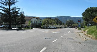
Woodside is a small incorporated town in San Mateo County, California, United States, on the San Francisco Peninsula. It has a council–manager system of government. The population of the town was 5,287 at the 2010 census.

Los Altos Hills is an incorporated town in Santa Clara County, California, United States. The population was 7,922 at the 2010 census.

Area code 650 is a California telephone area code in the San Francisco Bay Area that was split from area code 415 on August 2, 1997. It includes most of San Mateo County, part of San Francisco, and the northwestern portion of Santa Clara County including Palo Alto, Mountain View, and Los Altos.
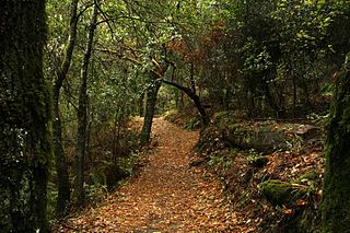
Los Trancos Open Space Preserve is a 274-acre open space preserve, located in San Mateo and Santa Clara Counties, California, near Los Altos Hills, California. The preserve contains about 5 miles of hiking trails, of which 2.1 miles are open to equestrians, and none are open to bicycles.

Diamond Heights is a neighborhood in central San Francisco, California, roughly bordered by Diamond Heights Boulevard and Noe Valley to the north and east and Glen Canyon Park to the south and west.

Ladera is a census-designated place (CDP) in southern San Mateo County, California, adjacent to Portola Valley. Primarily a residential community, it comprises approximately 520 homes. The ZIP Code is 94028 and the community is inside area code 650. The population was 1,426 at the 2010 census.

The Sequoia Union High School District is a public union school district in the San Francisco Bay Area, primarily serving the eastern San Mateo County communities of Atherton, Belmont, East Palo Alto, Ladera, San Carlos, Menlo Park, Portola Valley, Redwood City, and Woodside. The district also owns radio station KCEA.
Middleton Tract is a rural community in the coastal Redwoods of San Mateo County, California. Unattributed press reports say the name Middleton Tract may have been applied to this area as early as 1925. In the present day, the name is official at the county government level. It appears on County Assessor's maps including County of San Mateo, Master Index Map, Revision 2, June, 1985,, page 40-41.

Kings Mountain is an unincorporated community in San Mateo County, California, located along State Route 35 between Skeggs Point and Pise Mountain. This is about seven miles (11 km) north of Woodside Road (SR84). In the U.S. Geological Survey, National Geographic Names Database, the area is identified only as a geographic feature of type "summit" and not as a populated place. The community is inside area code 650 and uses the Woodside ZIP Code 94062.

Sky Londa is an unincorporated mountain community in San Mateo County, California located at the intersection of State Route 84 and State Route 35. The community is inside area code 650 and ZIP code 94062.

San Francisquito Creek is a creek that flows into southwest San Francisco Bay in California, United States. Historically it was called the Arroyo de San Francisco by Juan Bautista de Anza in 1776. San Francisquito Creek courses through the towns of Portola Valley and Woodside, as well as the cities of Menlo Park, Palo Alto, and East Palo Alto. The creek and its Los Trancos Creek tributary define the boundary between San Mateo and Santa Clara counties.
Corinda Los Trancos Creek is a 1.6-mile-long (2.6 km) stream in San Mateo County, California which is a tributary of Pilarcitos Creek.

The Phleger Estate is a park in San Mateo County, California. The park is located outside the town of Woodside and adjacent to Huddart County Park. The park was acquired in 1991 by the Peninsula Open Space Trust (POST) for $25 million and is now part of the Golden Gate National Recreation Area (GGNRA).

Rancho el Corte de Madera was a 13,316-acre (53.89 km2) Mexican land grant in present day Santa Clara County, California given in 1844 by Governor Manuel Micheltorena to Máximo Martínez. The name translates as "the place where lumber is cut". The roughly triangular shaped grant was west of today's I-280, and bounded on the north by Alambique Creek and San Francisquito Creek, on the south by Los Trancos Creek and Matadero Creek, and on the west by what is now Skyline Boulevard. The grant surrounded Rancho Cañada del Corte de Madera which extended along the Portola Valley. The land grant included parts of present day Woodside, Ladera and Stanford University.
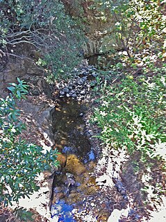
Los Trancos Creek is a creek that flows northerly from Monte Bello Ridge on the northeast slope of the Santa Cruz Mountains to its confluence with San Francisquito Creek at Stanford University in California, United States. The creek forms the boundary between northwestern Santa Clara County and southeastern San Mateo County.

The Peninsula Library System (PLS) is a consortium of public and community college libraries in San Mateo County, California, United States, which serves the part of the San Francisco Bay Area known as "The Peninsula". The system has dozens of branches in local communities and at various area community colleges, a bookmobile, and automated book kiosks called Library-a-Go-Go.
Sausal Creek is a 2.5-mile-long (4.0 km) northwesterly-flowing stream originating in Portola Valley along the northeastern edge of the Windy Hill Open Space Preserve in the eastern foothills of the Santa Cruz Mountains, in San Mateo County, California, United States. It joins a nexus of creeks becoming Corte Madera Creek in a natural marsh above Searsville Reservoir on Stanford University lands. Below Searsville Reservoir, Corte Madera Creek joins with Bear Creek to form San Francisquito Creek and flows to San Francisco Bay.

West Santa Clara is an unincorporated census county division (CCD) located on the eastern side of the Santa Cruz Mountains in northwest Santa Clara County, California. The area covers approximately 50 square miles (130 km2), much of it open space, and contains Boronda Lake, Felt Lake, and Lake Ranch reservoirs, as well as Sanborn and Stevens Creek county parks. The Foothills, Los Trancos, Monte Bello, Pearson-Arastradero, Picchetti Ranch, Rancho San Antonio and Saratoga Gap preserves are also located in the area.

