Tunitas, California

Last updated
Tunitas, California
USA California location map.svg
Red pog.svg
Tunitas, California
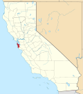
Location within the state of California
Coordinates: 37°22′59″N122°23′57″W / 37.38306°N 122.39917°W / 37.38306; -122.39917 Coordinates: 37°22′59″N122°23′57″W / 37.38306°N 122.39917°W / 37.38306; -122.39917
Country United States
State California
County San Mateo
Time zone UTC-8 (Pacific (PST))
  Summer (DST) UTC-7 (PDT)
Tunitas on 1940 USGS topo map Tunitas 1940 HMB Quad.jpg
Tunitas on 1940 USGS topo map
Early planning of rail stops included a station or flag stop at Lobitos near the Tunitas community OSRR with Lobitos and Tunitas Stations.jpg
Early planning of rail stops included a station or flag stop at Lobitos near the Tunitas community
The Ocean Shore Railway Tunitas station along Tunitas Creek not by the town. Tunitas Station.jpg
The Ocean Shore Railway Tunitas station along Tunitas Creek not by the town.

Tunitas, California was a small unincorporated community in San Mateo County. It was originally located on State Route 1 until that state route was moved to the west. It was also renamed Lobitos. [1]

Arroyo de las Tunitas is shown on the diseños, about 1839, of the San Gregorio and Canada Verde grants. [2] The name means “A small bush…grows super-abundant at and near its mouth, and its fruit is known to the present generation as sea apples.” [3]

Related Research Articles

Niagara River river in Canada and the USA

The Niagara River is a river that flows north from Lake Erie to Lake Ontario. It forms part of the border between the province of Ontario in Canada and the state of New York in the United States. There are differing theories as to the origin of the river's name. According to Iroquoian scholar Bruce Trigger, Niagara is derived from the name given to a branch of the locally residing native Neutral Confederacy, who are described as being called the Niagagarega people on several late-17th-century French maps of the area. According to George R. Stewart, it comes from the name of an Iroquois town called Ongniaahra, meaning "point of land cut in two".

Mojave River intermittent river in California

The Mojave River is an intermittent river in the eastern San Bernardino Mountains and the Mojave Desert in San Bernardino County, California, United States. Most of its flow is underground, while its surface channels remain dry most of the time, with the exception of the headwaters and several bedrock gorges in the lower reaches.

Santa Clara River Valley valley in Ventura County, California, USA

The Santa Clara River Valley is a rural, mainly agricultural, valley in Ventura County, California that has been given the moniker Heritage Valley by the namesake tourism bureau. The valley includes the communities of Santa Paula, Fillmore, Piru and the national historic landmark of Rancho Camulos. Named for the Santa Clara River, which winds through the valley before emptying into the Pacific Ocean between the cities of Ventura and Oxnard, the tourist bureau describes it as ".... Southern California's last pristine agricultural valley nestled along the banks of the free-flowing Santa Clara River."

Chino Hills

The Chino Hills are a mountain range on the border of Orange, Los Angeles, and San Bernardino counties, California, with a small portion in Riverside County. The Chino Hills State Park preserves open space and habitat in them.

Barnard (Martian crater) crater on Mars

Barnard is a crater on Mars named after American astronomer Edward Emerson Barnard.

Earthquake location

The primary purpose of a seismometer is to locate the initiating points of earthquake epicenters. The secondary purpose, of determining the 'size' or Moment magnitude scale must be calculated after the precise location is known.

Sky Londa, California Unincorporated community in California, United States

Sky Londa is an unincorporated mountain community in San Mateo County, California located at the intersection of State Route 84 and State Route 35. The community is inside area code 650 and ZIP code 94062.

Purissima, California Ghost town in California, United States

Purissima is a ghost town in southwestern San Mateo County, California, United States, near the junction of State Route 1 and Verde Road. Purísima means "purest" in Spanish and is most commonly used in Spanish to refer to La Purísima Concepción of the Virgin Mary. Purissima is the name of the town used as the setting for Ross Macdonald's 1958 crime fiction novel 'The Doomsters'.

Providence Mountains State Recreation Area

The Providence Mountains State Recreation Area is located in the Providence Mountains, within the Mojave National Preserve in San Bernardino County, California. It is also home to the Mitchell Caverns Natural Preserve.

Audubon Canyon

Audubon Canyon is a coastal valley in Marin County, California, United States, which is associated with a small stream. The canyon provides habitat for a variety of animals and plants. Notably, its redwoods provide nesting sites for great blue herons, great egrets, and snowy egrets.

Tunitas Creek river in the United States of America

Tunitas Creek is a 6.6-mile-long (10.6 km) stream in San Mateo County, California. Tunitas is Spanish for "little prickly pears".

Dry Creek is a small river in San Mateo County, California and is a tributary of Tunitas Creek.

Mitchell Creek is a small river in San Mateo County, California, and is a tributary of Tunitas Creek.

Rings Gulch is a valley in San Mateo County, California. It contains a stream which is a tributary of Tunitas Creek.

East Fork Tunitas Creek is a small river in San Mateo County, California and is a tributary of Tunitas Creek.

Lobitos, California Populated place in California, United States

Lobitos, California is a populated place in San Mateo County, just east of State Route 1 and south of Half Moon Bay and the ghost town of Purissima. It is 165 feet (50.3 m) above sea level.

Astapus Colles colles on Mars

Astapus Colles is a group of hills in the Casius quadrangle of Mars, located at 35.5 North and 272.3 West. It is 580 km across and was named after an albedo feature at 35N, 269W. The term "Colles" is used for small hills or knobs.

Claritas Rupes rupes on Mars

Claritas Rupes is a scarp in the Phoenicis Lacus quadrangle of Mars, located at 26° South and 105.4° West. It is 924 km long and was named after an albedo feature at 25S, 110W. The term "Rupes" is used in planetary geology to refer to an escarpments or cliff on Mars and other planets. It is the Latin word for cliff.

Coyote Creek (San Gabriel River tributary) stream in Southern California, tributary of the San Gabriel River

Coyote Creek is a principal tributary of the San Gabriel River in northwest Orange County, southeast Los Angeles County, and southwest Riverside County, California. It drains a land area of roughly 41.3 square miles (107 km2) covering five major cities, including Brea, Buena Park, Fullerton, La Habra, and La Palma. Some major tributaries of the creek in the highly urbanized watershed include Brea Creek, Fullerton Creek, and Carbon Creek. The mostly flat creek basin is separated by a series of low mountains, and is bounded by several small mountain ranges, including the Chino Hills, Puente Hills and West Coyote Hills.

Springtown, California Unincorporated community in California, United States

Springtown is an unincorporated community in Monterey County, California, United States.

References

  1. http://bard.wr.usgs.gov/historical/jpg/halfmoonbay1940a.jpg; http://bard.wr.usgs.gov/historical/jpg/halfmoonbay1961a.jpg
  2. Gudde, Erwin G. (1998). California place names : the origin and etymology of current geographical names (4th ed., rev. and enl. ed.). Berkeley: University of California Press. p.  403. ISBN   0520213165.
  3. http://www.pescaderomemories.com/2008/02/21/more-tunitas/