Loma Mar, California

Last updated
Loma Mar
Loma Mar California.jpg
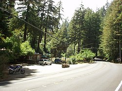
View of the Loma Mar General Store
San Mateo County California Incorporated and Unincorporated areas Loma Mar Highlighted 0642384.svg
Location within San Mateo County
USA California location map.svg
Red pog.svg
Loma Mar
Location within the state of California
Coordinates: 37°16′16″N122°18′27″W / 37.27111°N 122.30750°W / 37.27111; -122.30750 Coordinates: 37°16′16″N122°18′27″W / 37.27111°N 122.30750°W / 37.27111; -122.30750
Country United States
State California
County San Mateo
Area
[1]
  Total1.735 sq mi (4.493 km2)
  Land1.735 sq mi (4.493 km2)
  Water0 sq mi (0 km2)  0%
Elevation
[2]
866 ft (264 m)
Population
 (2020)
  Total134
  Density77/sq mi (30/km2)
Time zone UTC-8 (Pacific (PST))
  Summer (DST) UTC-7 (PDT)
ZIP codes
94021
Area code(s) 650
GNIS feature ID2628753

Loma Mar (Spanish for "Sea Hill") is a census-designated place (CDP) in San Mateo County, California. [2] It is near San Mateo County Memorial Park on Pescadero Creek Road and is in area code 650. Loma Mar is between the towns of Pescadero and La Honda, situated in the Santa Cruz Mountains in the western part of the San Francisco Peninsula. The United States Postal Service has assigned it ZIP Code 94021. As of the census [3] of 2020, there were 134 residents in the CDP. [4] Loma Mar is home to the YMCA's Camp Loma Mar, Redwood Glen Camp and Conference Center as well as a small number of businesses and services including the Loma Mar Store, a post office, and a fire station run by volunteers. [5]

Contents

Geography

The town is located within a redwood forest, and is traversed by the Pescadero Creek.

According to the United States Census Bureau, the CDP covers an area of 1.7 square miles (4.5 km2), all of it land.

Demographics

The 2010 United States Census [6] reported that Loma Mar had a population of 113. The population density was 65.1 inhabitants per square mile (25.1/km2). The racial makeup of Loma Mar was 101 (89.4%) White, 2 (1.8%) African American, 0 (0.0%) Native American, 3 (2.7%) Asian, 0 (0.0%) Pacific Islander, 0 (0.0%) from other races, and 7 (6.2%) from two or more races. Hispanic or Latino of any race were 12 persons (10.6%).

The Census reported that 113 people (100% of the population) lived in households, 0 (0%) lived in non-institutionalized group quarters, and 0 (0%) were institutionalized.

There were 54 households, out of which 12 (22.2%) had children under the age of 18 living in them, 24 (44.4%) were opposite-sex married couples living together, 1 (1.9%) had a female householder with no spouse present, 0 (0%) had a male householder with no spouse present. There were 5 (9.3%) unmarried opposite-sex partnerships, and 1 (1.9%) same-sex married couples or partnerships. 21 households (38.9%) were made up of individuals, and 3 (5.6%) had someone living alone who was 65 years of age or older. The average household size was 2.09. There were 25 families (46.3% of all households); the average family size was 2.96.

The population was spread out, with 22 people (19.5%) under the age of 18, 2 people (1.8%) aged 18 to 24, 33 people (29.2%) aged 25 to 44, 47 people (41.6%) aged 45 to 64, and 9 people (8.0%) who were 65 years of age or older. The median age was 44.8 years. For every 100 females, there were 117.3 males. For every 100 females age 18 and over, there were 97.8 males.

There were 67 housing units at an average density of 38.6 per square mile (14.9/km2), of which 31 (57.4%) were owner-occupied, and 23 (42.6%) were occupied by renters. The homeowner vacancy rate was 0%; the rental vacancy rate was 0%. 68 people (60.2% of the population) lived in owner-occupied housing units and 45 people (39.8%) lived in rental housing units.

Schools

Loma Mar is within the boundaries of the La Honda-Pescadero Unified School District and has a bus stop located on Pescadero Creek Road across from the store, but does not have a school of its own.

Related Research Articles

San Mateo County, California County in California, United States

San Mateo County, officially the County of San Mateo, is a county located in the U.S. state of California. As of the 2020 census, the population was 764,442. Redwood City is the county seat, and the third most populated city following Daly City and San Mateo. San Mateo County is included in the San Francisco-Oakland-Berkeley, CA MSA, Silicon Valley, and is part of the San Francisco Bay Area, the nine counties bordering San Francisco Bay. It covers most of the San Francisco Peninsula. San Francisco International Airport is located in the northeastern area of the county and is approximately 7 miles south of the city and county limits of San Francisco, even though the airport itself is assigned a San Francisco postal address. The county's built-up areas are mostly suburban, and are home to several corporate campuses.

Cherryland, California Unincorporated Community in California, United States

Cherryland is an unincorporated community and census-designated place (CDP) in Alameda County, California, United States. Cherryland is located between Ashland to the north and the city of Hayward to the south. The population was 15,808 at the 2020 census.

Cantua Creek, California Census-designated place in California, United States

Cantua Creek is a census-designated place (CDP) in Fresno County, California, United States. As of the 2010 census, the population was 466, down from the 655 reported at the 2000 census. Cantua Creek is located 11 miles (18 km) south-southwest of Tranquillity, at an elevation of 295 feet.

Las Lomas, California Census-designated place in California, United States

Las Lomas is a census-designated place (CDP) in Monterey County, California, United States. Las Lomas is located 7 miles (11 km) north-northwest of Prunedale. The elevation is 43 feet. The population was 3,024 at the 2010 census, down from 3,078 at the 2000 census.

Mira Loma, California Former census-designated place in California, United States

Mira Loma, now officially part of Jurupa Valley, was a census-designated place (CDP) in Riverside County, California, United States. Its population was 21,930 in the 2010 census, up from 17,617 in the 2000 census.

Highlands-Baywood Park, California Unincorporated community in California, United States

Highlands-Baywood Park is an unincorporated community in San Mateo County, California, United States. The population was 4,027 at the 2010 census.

North Fair Oaks, California Census-designated place in California, United States

North Fair Oaks is a census-designated place and an unincorporated area located in San Mateo County, California adjacent to Redwood City, Atherton, and Menlo Park. As of the 2020 census the area had a total population of 14,027. Because of the large number of residents from one Mexican state the area is also known as Little Michoacán. The larger area including North Fair Oaks and adjacent parts of Redwood City has a large Latino population and is known locally as Little Mexico. The neighborhood is distinctive, as it is one out of only three communities in San Mateo County that have a majority Hispanic population.

Lexington Hills, California Census-designated place in California, United States

Lexington Hills is a census-designated place and an unincorporated area in Santa Clara County, California, United States. The population was 2,492 at the 2020 census. The area is located in the Santa Cruz Mountains, about five miles south of Los Gatos and about 14 miles (23 km) north of Santa Cruz. Lexington Hills is the name assigned by the United States Census Bureau to the area, which actually comprises several small communities, including Redwood Estates, Holy City, Chemeketa Park, and Aldercroft Heights.

Rio del Mar, California Census-designated place in California, United States

Rio del Mar is an unincorporated village in Santa Cruz County, California. Rio del Mar is one of several small villages that form the unincorporated community of Aptos, California. Its population was 9,128 as of the 2020 United States census.

Loma Rica, California Census-designated place in California, United States

Loma Rica is a census-designated place (CDP) in Yuba County, California, United States. The population was 2,368 at the 2010 census, up from 2,075 at the 2000 census. Loma Rica is located 15 miles (24 km) northeast of Marysville.

Montgomery Creek, California Census-designated place in California, United States

Montgomery Creek is a census-designated place in Shasta County, California, United States. Its population is 176 as of the 2020 census, up from 163 from the 2010 census. The town and associated creek were named after Zachariah Montgomery.

La Honda, California Census-designated place in California, United States

La Honda is a census-designated place (CDP) in southern San Mateo County, California, United States. The population was 979 at the 2020 census. It is located in the Santa Cruz Mountains between the Santa Clara Valley and the Pacific coast of California. La Honda is near the La Honda Creek Open Space Preserve and State Route 84 on the ocean side of the Coastal Range.

Pescadero, California Census-designated place in California, United States

Pescadero is an unincorporated town and census-designated place (CDP) in San Mateo County, California, two miles (3 km) east of State Route 1 and Pescadero State Beach. The town is 14.4 miles (23.2 km) south of Half Moon Bay. The ZIP Code is 94060 and the community is inside area code 650. The population was 595 at the 2020 census.

Hat Creek, California Census designated place in California, United States

Hat Creek is a census designated place (CDP) in Shasta County, California. Hat Creek is situated at an elevation of 3,422 feet (1,043 m). Its population is 266 as of the 2020 census, down from 309 from the 2010 census.

La Selva Beach, California Census-designated place in California, United States

La Selva Beach is a census-designated place (CDP) in Santa Cruz County, California. La Selva Beach sits at an elevation of 151 feet (46 m). The 2020 United States census reported La Selva Beach's population was 2,531.

Zayante is a census-designated place (CDP) in Santa Cruz County, California. It is a residential area located on Zayante Creek. Zayante sits at an elevation of 699 feet (213 m). The 2020 United States census reported Zayante's population was 729.

Leggett, California Census-designated place in California, United States

Leggett is a census-designated place in Mendocino County, California. It is located on the South Fork of the Eel River, 17 miles (27 km) northwest of Laytonville, at an elevation of 984 ft (300 m). It is home to some of the largest trees in the world. The nearby Smithe Redwoods State Reserve and the Standish-Hickey State Recreation Area are noted for their forests of Coastal Redwoods. The population was 77 at the 2020 census.

Seacliff is an unincorporated community in Santa Cruz County, California, United States that includes Seacliff State Beach. It is identified as one of several small communities with a combined population of 24,402 forming the unincorporated town of Aptos by the local Chamber of Commerce along with:

McGee Creek is a census-designated place in Mono County, California. McGee Creek sits at an elevation of 7,723 feet (2,354 m). The 2010 United States census reported McGee Creek's population was 41.

Sequoia Crest is a census-designated place (CDP) in Tulare County, California.The community of Sequoia Crest contains more than 150 Giant Sequoias scattered throughout the subdivision. Sequoia Crest sits at an elevation of 7,008 feet (2,136 m). The 2010 United States census reported Sequoia Crest's population was 10. Sequoia Crest can be reached from Porterville by 41 curvy miles most on California State Route 190 with an elevation gain of 6,549 feet.

References

  1. U.S. Census Archived 2012-01-25 at the Wayback Machine
  2. 1 2 U.S. Geological Survey Geographic Names Information System: Loma Mar, California
  3. "U.S. Census website". United States Census Bureau . Retrieved 2008-01-31.
  4. "Profile of General Population and Housing Characteristics: 2010 Demographic Profile Data (DP-1): Loma Mar CDP, California". United States Census Bureau . Retrieved April 5, 2012.
  5. "The Fire Department". Loma Mar Fire Department. Retrieved April 13, 2019.
  6. "2010 Census Interactive Population Search: CA - Loma Mar CDP". U.S. Census Bureau. Archived from the original on July 15, 2014. Retrieved July 12, 2014.

The Cottage at Where Water Falls