
Clay County is a county located in the U.S. state of Kentucky. As of the 2020 census, the county population was 20,345. Its county seat is Manchester. The county was formed in 1807 and named in honor of Green Clay (1757–1826). Clay was a member of the Virginia and Kentucky State legislatures, first cousin once removed of Henry Clay, U.S. Senator from Kentucky and Secretary of State in the 19th century.
Lee County is the westernmost county in the U.S. Commonwealth of Virginia. As of the 2020 census, the population was 22,173. Its county seat is Jonesville.
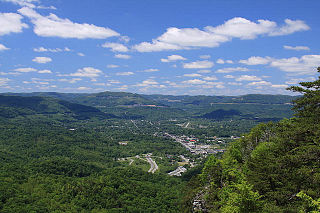
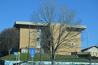
Middlesboro is a home rule-class city in Bell County, Kentucky, United States. The population was 10,334 at the 2010 U.S. census, while its micropolitan area had a population of 69,060.

The Ridge-and-Valley Appalachians, also called the Ridge and Valley Province or the Valley and Ridge Appalachians, are a physiographic province of the larger Appalachian division and are also a belt within the Appalachian Mountains extending from southeastern New York in the north through northwestern New Jersey, westward into Pennsylvania through the Lehigh Valley, and southward into Maryland, West Virginia, Virginia, Kentucky, Tennessee, Georgia, and Alabama. They form a broad arc between the Blue Ridge Mountains and the Appalachian Plateau physiographic province. They are characterized by long, even ridges, with long, continuous valleys in between.

The Cumberland Mountains are a mountain range in the southeastern section of the Appalachian Mountains. They are located in western Virginia, southwestern West Virginia, the eastern edges of Kentucky, and eastern middle Tennessee, including the Crab Orchard Mountains. Their highest peak, with an elevation of 4,223 feet (1,287 m) above mean sea level, is High Knob, which is located near Norton, Virginia.
The Middlesboro crater is a meteorite crater in Kentucky, United States. It is named after the city of Middlesborough, which today occupies much of the crater.

The Cumberland Gap National Historical Park is a United States National Historical Park located at the border between Kentucky, Tennessee, and Virginia, centered on the Cumberland Gap, a natural break in the Appalachian Mountains.

The Wilderness Road was one of two principal routes used by colonial and early national era settlers to reach Kentucky from the East. Although this road goes through the Cumberland Gap into southern Kentucky and northern Tennessee, the other is sometimes called the "Cumberland Road" because it started in Fort Cumberland in Maryland. Despite Kentucky Senator Henry Clay's advocacy of this route, early in the 19th century, the northern route was selected for the National Road, connecting near Washington, Pennsylvania into the Ohio Valley of northern Kentucky and Ohio.
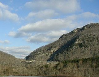
The Cumberland Gap is a pass in the eastern United States through the long ridge of the Cumberland Mountains, within the Appalachian Mountains and near the tripoint of Kentucky, Virginia, and Tennessee. At an elevation of 1,631 feet (497 m) above sea level, it is famous in American colonial history for its role as a key passageway through the lower central Appalachians.

The Battle of Mill Springs, also known as the Battle of Fishing Creek in Confederate terminology, and the Battle of Logan's Cross Roads in Union terminology, was fought in Wayne and Pulaski counties, near current Nancy, Kentucky, on January 19, 1862, as part of the American Civil War. The Union victory concluded an early Confederate offensive campaign in south central Kentucky.

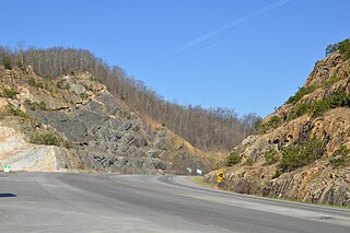
The Cumberland Gap Tunnel is a dual-bore, four lane vehicular tunnel that carries U.S. Route 25E under Cumberland Gap National Historical Park near the intersection of Kentucky, Tennessee, and Virginia. The tunnel consists of two separate bores which carry four lanes of traffic between Cumberland Gap, Tennessee and Middlesboro, Kentucky. It is one of only two mountain vehicular tunnels in the United States that cross a state line, the other being the East River Mountain Tunnel on Interstate 77 and U.S. Route 52 between Virginia and West Virginia. The tunnel opened to traffic in 1996 and replaced a section of highway through the Cumberland Gap that had earned the nickname "Massacre Mountain" due to its hazardous design and high rate of traffic accidents.
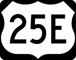
U.S. Route 25E is the eastern branch of U.S. Route 25 from Newport, Tennessee, where US 25 splits into US 25E and US 25W, to North Corbin, Kentucky, where the two highways rejoin. The road, however, continues as US 25E for roughly 2 miles (3.2 km) until it joins Interstate 75 in the Laurel County community of North Corbin at exit 29. The entire route serves as a arterial expressway for long-distance travelers and truckers connecting central Appalachia to the Great Lakes and Eastern Seaboard regions of the U.S. via access to Interstate highways.
State Route 80 is a primary state highway in the southwest part of the U.S. state of Virginia. It runs from the Kentucky state line at Breaks Interstate Park east to U.S. Route 11 near Meadowview. Kentucky Route 80 and Missouri's Route 80 continue the number west to Matthews, Missouri. The entire length of SR 80 is part of U.S. Bicycle Route 76.
The 7th Kentucky Infantry Regiment was an infantry regiment that served in the Union Army during the American Civil War.
The 38th Regiment Indiana Infantry was an infantry regiment that served in the Union Army during the American Civil War.
"Cumberland Gap" is an Appalachian folk song that likely dates to the latter half of the 19th century and was first recorded in 1924. The song is typically played on banjo or fiddle, and well-known versions of the song include instrumental versions as well as versions with lyrics. A version of the song appeared in the 1934 book, American Ballads and Folk Songs, by folk song collector John Lomax. Woody Guthrie recorded a version of the song at his Folkways sessions in the mid-1940s, and the song saw a resurgence in popularity with the rise of bluegrass and the American folk music revival in the 1950s. In 1957, the British musician Lonnie Donegan had a No. 1 UK hit with a skiffle version of "Cumberland Gap".
The Pound Gap of Pine Mountain is on the Virginia/Kentucky border between Jenkins, Kentucky and Pound, Virginia. It served as a passage for early settlers to cross into Kentucky from Virginia. Today, U.S. Route 23 passes through the gap.
Shelby Gap Railroad Station was an unincorporated community located in Pike County, Kentucky, United States. Its post office closed in 2004.

Blair Gap, one of the gaps of the Allegheny is a water gap along the eastern face atop the Allegheny Ridge or Allegheny Front escarpment. Like other gaps of the Allegheny, the slopes of Blair Gap were amenable to foot travel, pack mules, and possibly wagons allowing Amerindians, and then, after about 1778-1780 settlers, to travel west into the relatively depopulated Ohio Country decades before the railroads were born and tied the country together with steel. Historically, the gap was used for the upper sections of the Allegheny Portage Railroad, which as was authorized by the enabling acts in 1824 of Pennsylvania's Main Line of Public Works as part of the Pennsylvania Canal System which originally envisioned linking Pittsburgh to Philadelphia by canals. In the early 1900s, U.S. Route 22 followed alongside the watercourse through the gap.


