
Monroe County is a county in the state of Florida. As of the 2010 census, the population was 73,090. Its county seat is Key West. Monroe County includes the islands of the Florida Keys and comprises the Key West Micropolitan Statistical Area.
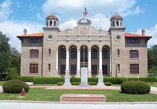
Sumter County is a county located in the state of Florida, United States. As of September 2016, the population according to county officials is 118,577. It has the oldest median age of any US county. Its county seat is Bushnell, and the largest community is The Villages.

Coral Gables, officially the City of Coral Gables, is a city in Miami-Dade County, Florida, United States, located southwest of Downtown Miami. The United States Census Bureau estimates conducted in 2017 yielded the city had a population of 51,095. Coral Gables is home to the University of Miami.

Cutler Bay is an incorporated town in Miami-Dade County, Florida established in 2005, with a population of approximately 44,700 as of 2016.

El Portal is a village in Miami-Dade County, Florida, United States. The village name is derived from the Spanish term for "the gate," after two wooden gates that once stood as a gateway to the village. El Portal was originally a neighborhood of the City of Miami when it was annexed into the City of Miami in 1925. With the arrival of the Great Depression, the City of Miami gave up its jurisdiction and El Portal was incorporated as its own village in 1937.

Fontainebleau is a census-designated place (CDP) in Miami-Dade County, Florida, United States. The population was 59,764 at the 2010 census.

Golden Beach is a town located in the northeast corner of Miami-Dade County, Florida, between the Intracoastal Waterway and Atlantic Ocean. As of the 2010 census, the town had a total population of 919.

Golden Glades is a census-designated place (CDP) in Miami-Dade County, Florida, United States. The population was 33,145 at the 2010 census.

Miami Lakes is a suburb of Miami, an incorporated town and former census-designated place in Miami-Dade County, Florida, United States. As of 2010 US Census, 29,361 people live in Miami Lakes.

Miami Springs is a city located in Miami-Dade County, Florida. The city was founded by Glenn Hammond Curtiss, "The Father of Naval Aviation", and James Bright, during the famous "land boom" of the 1920s and was originally named Country Club Estates. It, along with other cities in Miami-Dade County such as Coral Gables, Florida, and Opa-locka, Florida, formed some of the first planned communities in the state. Like its counterparts, the city had an intended theme which in its case, was to reflect a particular architecture and ambiance.

West Miami is a city in Miami-Dade County, Florida, United States. The population was 5,965 at the 2010 census.
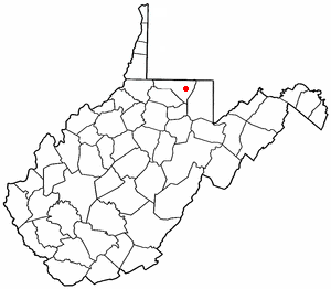
Brookhaven is a census-designated place (CDP) in Monongalia County, West Virginia, United States. The population was 5,171 at the 2010 census. It is included in the Morgantown, West Virginia Metropolitan Statistical Area.

The Flagami is a neighborhood of Miami, Florida, United States, roughly defined as south and east of the Tamiami Canal, north of the Tamiami Trail, and west of Red Road, bisected by Flagler Street.

The Rickenbacker Causeway is a causeway which connects Miami, Florida, United States to the barrier islands of Virginia Key and Key Biscayne across Biscayne Bay.
Spuds is an unincorporated community in St. Johns County, Florida, United States. The community is situated in a region that depends economically on potato growing and other agriculture. As well as potatoes, the land around Spuds provides gladioli. A camp for German prisoners of war was built in Spuds during World War II, close to the intersection between State Roads 206 and 207.
Ludlam Road, also West 67th Avenue, is a 21.8-mile (35.1 km) north–south street that runs west of downtown Miami in Miami-Dade County, Florida.

U.S. Route 441 (US 441) in Florida is a north–south United States Highway. It runs 433 miles (697 km) from Miami in South Florida northwest to the Georgia border north of the Lake City area.
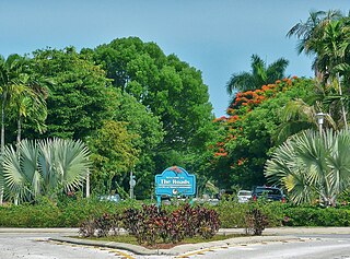
The Roads is a neighborhood of Miami in Miami-Dade County, Florida, United States. It is a triangular area located south of SW 11th Street, between SW 12th Avenue and SW 15th Road, just west of Brickell.
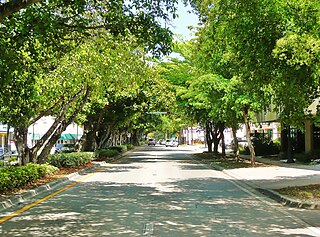
Coral Way is a neighborhood within Miami, Florida that is defined by Coral Way, a road established by Coral Gables founder George E. Merrick during the 1920s. It is located in Miami-Dade County, Florida, United States.

Miami Heights is a census-designated place (CDP) in Miami Township, Hamilton County, Ohio, United States. The population was 4,731 at the 2010 census.


