
The Trans-Canada Highway is a transcontinental federal-provincial highway system that travels through all ten provinces of Canada from the Pacific Ocean on the west to the Atlantic on the east. The main route spans 7,821 km (4,860 mi) across the country, one of the longest routes of its type in the world. The highway system is recognizable by its distinctive white-on-green maple leaf route markers, although there are small variations in the markers in some provinces.

Lake of the Woods is a lake occupying parts of the Canadian provinces of Ontario and Manitoba and the U.S. state of Minnesota. It separates a small land area of Minnesota from the rest of the United States. The Northwest Angle and the town of Angle Township can be reached from the rest of Minnesota only by crossing the lake or by traveling through Canada. The Northwest Angle is the northernmost part of the contiguous United States. Its "northwesternmost point" served as a problematic landmark in treaties defining the international border.

The Yellowhead Highway is a major interprovincial highway in Western Canada that runs from Winnipeg to Graham Island off the coast of British Columbia via Saskatoon and Edmonton. It stretches across the four western Canadian provinces of British Columbia, Alberta, Saskatchewan, and Manitoba and is part of the Trans-Canada Highway system and the larger National Highway System, but should not be confused with the more southerly, originally-designated Trans-Canada Highway. The highway was officially opened in 1970. Beginning in 1990, the green and white Trans-Canada logo was used to designate the roadway.

The Pigeon River forms part of the Canada–United States border between the state of Minnesota and the province of Ontario, west of Lake Superior. In pre-industrial times the river was a waterway of great importance for transportation and the fur trade.
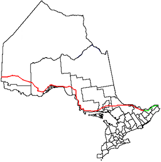
King's Highway 17, more commonly known as Highway 17, is a provincially maintained highway and the primary route of the Trans-Canada Highway through the Canadian province of Ontario. It begins at the Manitoba boundary, 50 km (31 mi) west of Kenora, and the main section ends where Highway 417 begins just west of Arnprior. A small disconnected signed section of the highway still remains within the Ottawa Region between County Road 29 and Grants Side Rd. This makes it Ontario's longest highway.
King's Highway 11, commonly referred to as Highway 11, is a provincially maintained highway in the Canadian province of Ontario. At 1,784.9 kilometres (1,109.1 mi), it is the second longest highway in the province, following Highway 17. Highway 11 begins at Highway 400 in Barrie, and arches through northern Ontario to the Ontario–Minnesota border at Rainy River via Thunder Bay; the road continues as Minnesota State Highway 72 across the Baudette-Rainy River International Bridge. North and west of North Bay, Highway 11 forms part of the Trans-Canada Highway. The highway is also part of MOM's Way between Thunder Bay and Rainy River.

King's Highway 61, commonly referred to as Highway 61 and historically known as the Scott Highway, is a provincially maintained highway in the Canadian province of Ontario. The 61-kilometre (38 mi) route connects the Pigeon River Bridge, where it crosses into the United States and becomes Minnesota State Highway 61, with a junction at Highway 11, Highway 17 and the Harbour Expressway in Thunder Bay. The highway forms part of the Lake Superior Circle Tour.
Provincial Trunk Highway 1 is Manitoba's section of the Trans-Canada Highway. It is a heavily used, 4-lane divided highway, with the exception of a short 18 km section in the southeastern corner of the province. It is the main link between southern Manitoba's largest cities, and also serves as the province's main transportation link to the neighbouring provinces of Saskatchewan and Ontario. The highway is the only major east-west divided highway in Manitoba, and carries a large majority of east-west traffic within and through the province. It has full freeway status sections at Portage la Prairie and Winnipeg. The total distance of the Trans-Canada Highway in Manitoba is approximately 490 km (300 mi).
Provincial Trunk Highway 4 is a provincial highway in the Canadian province of Manitoba. The highway connects the city of Selkirk to PTH 59, the main route to Grand Beach and cottage country on the east side of Lake Winnipeg.
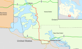
King's Highway 71, commonly referred to as Highway 71, is a provincially maintained highway in the Canadian province of Ontario. The 194-kilometre-long (121 mi) route begins at the Fort Frances–International Falls International Bridge in Fort Frances, continuing from US Highway 53 (US 53) and US 71 in Minnesota, and travels west concurrently with Highway 11 for 40 kilometres (25 mi) to Chapple. At that point, Highway 11 continues west while Highway 71 branches north and travels 154 kilometres (96 mi) to a junction with Highway 17 just east of Kenora. Highway 71 is part of the Trans-Canada Highway for its entire length, with the exception of the extremely short segment south of Highway 11 in Fort Frances.

Alberta Provincial Highway No. 55, commonly referred to as Highway 55, is a 263-kilometre (163 mi) long east–west highway in northeast Alberta, Canada. It extends from the Saskatchewan border in the east through the Cold Lake, Lac La Biche, and Athabasca where it ends at Highway 2. In Saskatchewan, it continues as Saskatchewan Highway 55.
Minnesota State Highway 11 is a 209.971-mile-long (337.916 km) highway in northwest and north-central Minnesota, which runs from North Dakota Highway 66 at the North Dakota state line and continues east to its eastern terminus at the community of Island View on Dove Island, near International Falls.
Minnesota State Highway 72 (MN 72) is a 76.810-mile-long (123.614 km) highway in northwest Minnesota, which runs from its intersection with U.S. 71 in Blackduck and continues north to its northern terminus at the Canada–US border in Baudette. The road continues as Ontario Highway 11 upon entering the town of Rainy River, Ontario at the Baudette-Rainy River International Bridge.
Minnesota State Highway 313 (MN 313) is a highway in northwest Minnesota, which runs from its intersection with State Highway 11 in Warroad and continues north to its northern terminus at the Canada–US border; where the route becomes Manitoba Highway 12 upon crossing the border, near the communities of Middlebro and Sprague, Manitoba.

Provincial Trunk Highway 12 is a provincial primary highway located in the Canadian province of Manitoba. It runs from the U.S. border to a dead end in Grand Beach. PTH 12 forms the Manitoba section of MOM's Way, a tourist route from Thunder Bay to Winnipeg. PTH 12 is primarily a two-lane highway except for two four-lane stretch between Steinbach and PTH 1 and a ten-kilometre concurrency with PTH 44.
King's Highway 102, commonly referred to as Highway 102, formerly as Highway 11A and Highway 17A and historically as the Dawson Road, is a provincially maintained highway in the Canadian province of Ontario, serving as a northern bypass to the city of Thunder Bay for all vehicle traffic. Both the western and eastern termini of Highway 102 are with the concurrency of Highway 11 and Highway 17; in the rural community of Sistonens Corners to the west and in Thunder Bay to the east. The majority of Highway 102 is surrounded by thick forests and swamps. However, owing to its historic nature, it is lined with residences outside of urban Thunder Bay.

Lake St. Joseph is a large lake in Kenora District and Thunder Bay District in Northwestern Ontario, Canada. It is in the James Bay drainage basin and is the source of the Albany River. The east end of the lake can be reached using Ontario Highway 599 from the town of Ignace, 260 kilometres (160 mi) to the south on Ontario Highway 17. The nearest town is Pickle Lake, 30 kilometres (19 mi) north along Highway 599.
The Great Lakes Circle Tour is a designated scenic road system connecting all of the Great Lakes and the St. Lawrence River. It consists of routes for circumnavigating the lakes, either individually or collectively.
The Old Dawson Trail is the remnant of the first all-Canadian route that linked the Great Lakes with the Canadian prairies. It was a water and land route that began at Port Arthur, Ontario and ended at St. Boniface, Manitoba. The land portions of the trail are usually referred to as Dawson Road.

The Warroad–Sprague Border Crossing connects the city of Warroad, Minnesota and community of Sprague, Manitoba on the Canada–United States border.