Maddock, North Dakota | |
---|---|
Coordinates: 47°57′45″N99°31′45″W / 47.96250°N 99.52917°W | |
Country | United States |
State | North Dakota |
County | Benson |
Founded | 1901 |
Area | |
• Total | 0.88 sq mi (2.28 km2) |
• Land | 0.88 sq mi (2.28 km2) |
• Water | 0.00 sq mi (0.00 km2) |
Elevation | 1,581 ft (482 m) |
Population | |
• Total | 402 |
• Estimate (2022) [4] | 385 |
• Density | 455.78/sq mi (175.99/km2) |
Time zone | UTC-6 (Central (CST)) |
• Summer (DST) | UTC-5 (CDT) |
ZIP code | 58348 |
Area code | 701 |
FIPS code | 38-49620 |
GNIS feature ID | 1036144 [2] |
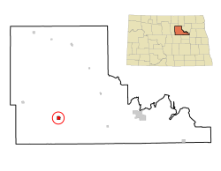
Maddock is a city in Benson County, North Dakota, United States. The population was 402 at the 2020 census. [3] Maddock was founded in 1901.
According to the United States Census Bureau, the city has a total area of 0.89 square miles (2.31 km2), all land. [5]
Census | Pop. | Note | %± |
---|---|---|---|
1910 | 374 | — | |
1920 | 557 | 48.9% | |
1930 | 631 | 13.3% | |
1940 | 691 | 9.5% | |
1950 | 741 | 7.2% | |
1960 | 740 | −0.1% | |
1970 | 708 | −4.3% | |
1980 | 677 | −4.4% | |
1990 | 559 | −17.4% | |
2000 | 498 | −10.9% | |
2010 | 382 | −23.3% | |
2020 | 402 | 5.2% | |
2022 (est.) | 385 | [4] | −4.2% |
U.S. Decennial Census [6] 2020 Census [3] |
As of the census of 2010, there were 382 people, 196 households, and 103 families living in the city. The population density was 429.2 inhabitants per square mile (165.7/km2). There were 253 housing units at an average density of 284.3 per square mile (109.8/km2). The racial makeup of the city was 95.5% White, 0.3% African American, 3.1% Native American, 0.3% Asian, and 0.8% from two or more races. Hispanic or Latino of any race were 1.6% of the population.
There were 196 households, of which 19.4% had children under the age of 18 living with them, 42.9% were married couples living together, 7.1% had a female householder with no husband present, 2.6% had a male householder with no wife present, and 47.4% were non-families. 43.4% of all households were made up of individuals, and 21.4% had someone living alone who was 65 years of age or older. The average household size was 1.95 and the average family size was 2.69.
The median age in the city was 49.3 years. 18.6% of residents were under the age of 18; 6.9% were between the ages of 18 and 24; 19.3% were from 25 to 44; 30.7% were from 45 to 64; and 24.6% were 65 years of age or older. The gender makeup of the city was 50.8% male and 49.2% female.
As of the census of 2000, there were 498 people, 238 households, and 127 families living in the city. The population density was 564.7 inhabitants per square mile (218.0/km2). There were 276 housing units at an average density of 313.0 per square mile (120.8/km2). The racial makeup of the city was 99.60% White, 0.20% Native American, and 0.20% from two or more races. Hispanic or Latino of any race were 0.20% of the population.
There were 238 households, out of which 19.7% had children under the age of 18 living with them, 41.6% were married couples living together, 7.1% had a female householder with no husband present, and 46.6% were non-families. 45.0% of all households were made up of individuals, and 31.5% had someone living alone who was 65 years of age or older. The average household size was 1.92 and the average family size was 2.67.
In the city, the population was spread out, with 16.9% under the age of 18, 3.0% from 18 to 24, 20.5% from 25 to 44, 18.9% from 45 to 64, and 40.8% who were 65 years of age or older. The median age was 53 years. For every 100 females, there were 85.1 males. For every 100 females age 18 and over, there were 78.4 males.
The median income for a household in the city was $23,636, and the median income for a family was $32,500. Males had a median income of $23,750 versus $16,042 for females. The per capita income for the city was $15,662. About 9.6% of families and 13.0% of the population were below the poverty line, including 8.2% of those under age 18 and 13.1% of those age 65 or over.
This climatic region is typified by large seasonal temperature differences, with warm to hot (and often humid) summers and cold (sometimes severely cold) winters. According to the Köppen Climate Classification system, Maddock has a humid continental climate, abbreviated "Dfb" on climate maps. [7]
Hartford is a town in Oxford County, Maine, United States. Hartford is included in the Lewiston-Auburn metropolitan New England City and Town Area. The population was 1,203 at the 2020 census.
Ferrysburg is a city in Ottawa County in the U.S. state of Michigan. The population was 2,892 at the 2010 census.
Rosebud is a city in Gasconade County, Missouri, United States. The population was 390 at the 2020 census.
Laurie is a city in southern Morgan and northern Camden counties, Missouri, United States. The population was 945 at the 2010 census.
Warwick is a city in Benson County, North Dakota, United States. The population was 55 at the 2020 census. Warwick was founded in 1907.
Powers Lake is a city in Burke County, North Dakota, United States. The population was 385 at the 2020 census. Powers Lake was founded in 1909.
Carson is a city in and the county seat of Grant County, North Dakota, United States. The population was 254 at the 2020 census.
Velva is a city in McHenry County, North Dakota, United States. Part of the Minot Micropolitan Statistical Area, it was founded in 1897 and the population was 1,086 at the 2020 census. Southeast of Minot, Velva is at the southernmost point of the Souris River.
Wishek is a city in McIntosh County, North Dakota, United States. The population was 864 at the 2020 census.
Hankinson is a city in Richland County, North Dakota, United States. The population was 921 at the 2020 census. Hankinson was founded in 1886. It is part of the Wahpeton, ND–MN Micropolitan Statistical Area.
Sharon is a city in Steele County, North Dakota, United States. The population was 86 at the 2020 census. Sharon was founded in 1896.
Courtenay is a city in Stutsman County, North Dakota, United States. The population was 36 at the 2020 census. Courtenay was founded in 1893.
Richland is a city in Baker County, Oregon, United States. The population was 156 at the 2010 census.
Bay City is a city in Tillamook County, Oregon, United States. The population was 1,286 at the 2010 census.
Pilot Rock is a city in Umatilla County, Oregon, United States. The population was 1,502 at the 2010 census. It is part of the Pendleton–Hermiston Micropolitan Statistical Area. The main industries are timber and agriculture. Pilot Rock is home to the Boise Cascade /Kinzua Lumber lumber and pole mill as well as Pilot Rock High School. The name of Pilot Rock refers to a large basalt rock formation which is visible from the old Oregon Trail and was used in navigating wagon trains through the area.
Parkston is a city in Hutchinson County, South Dakota, United States. The population was 1,567 at the 2020 census.
Burnsville is a town in Braxton County, West Virginia, United States, at the confluence of the Little Kanawha River and Saltlick Creek. The population was 401 at the 2020 census. Burnsville was incorporated in 1902 by the Circuit Court and named for Captain John Burns who operated the first sawmill in that section of the state and who established the town shortly after the close of the American Civil War. It was named "All West Virginia City" in 1976.
Beech Bottom is a village in Brooke County, West Virginia, United States, situated along the Ohio River. The population was 523 at the 2010 census. It is part of the Weirton–Steubenville metropolitan area.
Cairo is a town in Ritchie County, West Virginia, United States, along West Virginia Route 31, the North Fork of the Hughes River, and the North Bend Rail Trail. The population was 174 at the 2020 census.
Smithfield is a town in Wetzel County, West Virginia, United States. The population was 103 at the 2020 census.