Map showing the territory inhabited by the Manche Ch'ol in the 17th century
The Manche Ch'ol were a former Ch'ol-speaking Maya people inhabiting the extreme south of what is now the Petén Department of modern Guatemala, the area around Lake Izabal (also known as the Golfo Dulce), and southern Belize.[1] The Manche Ch'ol took the name Manche from the name of their main settlement. They were the last group of eastern Cholan-speakers to remain independent and ethnically distinct.[2] It is likely that they were descended from the inhabitants of Classic period (c. 250-900 AD) Maya cities in the southeastern Maya region, such as Nim Li Punit, Copán and Quiriguá.
The Maya peoples are a large group of indigenous peoples of Mesoamerica. They inhabit southern Mexico, Guatemala, Belize, El Salvador and Honduras. The overarching term "Maya" is a collective designation to include the peoples of the region that share some degree of cultural and linguistic heritage; however, the term embraces many distinct populations, societies and ethnic groups that each have their own particular traditions, cultures and historical identity.
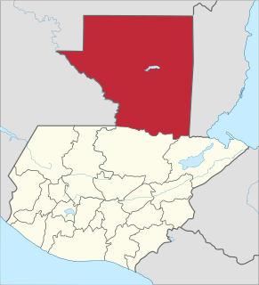
Petén is a department of the Republic of Guatemala. It is geographically the northernmost department of Guatemala, as well as the largest by area — at 13,843 sq mi (35,854 km2) it accounts for about one third of Guatemala's area. The capital is Flores. The population at the 2002 Census was 366,735; the latest official estimate as of mid-2012 was 662,779.
Guatemala, officially the Republic of Guatemala, is a country in Central America bordered by Mexico to the north and west, Belize and the Caribbean to the northeast, Honduras to the east, El Salvador to the southeast and the Pacific Ocean to the south. With an estimated population of around 16.6 million, it is the most populated country in Central America. Guatemala is a representative democracy; its capital and largest city is Nueva Guatemala de la Asunción, also known as Guatemala City.
The first Spanish contact with the Manche Ch'ol was in 1525, when an expedition led by Hernán Cortés crossed their territory. From the early 17th century onwards, Dominican friars attempted their concentration into mission towns and their conversion to Christianity. These attempts alarmed their warlike Itza neighbours to the northwest, who attacked the mission towns and fomented rebellion among the Manche. The Manche Ch'ol in the mission towns were badly affected by disease, which also encouraged them to flee the towns.
Hernán Cortés de Monroy y Pizarro Altamirano, Marquis of the Valley of Oaxaca was a Spanish Conquistador who led an expedition that caused the fall of the Aztec Empire and brought large portions of what is now mainland Mexico under the rule of the King of Castile in the early 16th century. Cortés was part of the generation of Spanish colonizers who began the first phase of the Spanish colonization of the Americas.
The Order of Preachers, also known as the Dominican Order, is a mendicant Catholic religious order founded by the Spanish priest Dominic of Caleruega in France, approved by Pope Honorius III via the Papal bull Religiosam vitam on 22 December 1216. Members of the order, who are referred to as Dominicans, generally carry the letters OP after their names, standing for Ordinis Praedicatorum, meaning of the Order of Preachers. Membership in the order includes friars, nuns, active sisters, and affiliated lay or secular Dominicans.
A religious mission or mission station is a location for missionary work.
In the late 17th century, Franciscan missionaries argued that further attempts at peaceful pacification of the Ch'ol were useless and argued for armed intervention against the Manche Ch'ol and their Lakandon Ch'ol neighbours. The Manche were forcibly relocated in the Guatemalan Highlands, where they did not prosper. By 1770, most of the Manche Ch'ol were extinct. The few survivors were soon absorbed into the surrounding Q'eqch'i Maya population.
The Guatemalan Highlands is an upland region in southern Guatemala, lying between the Sierra Madre de Chiapas to the south and the Petén lowlands to the north. The highlands are made up of a series of high valleys enclosed by mountains. The local name for the region is Altos, meaning "highlands", which includes the northern declivity of the Sierra Madre. The mean elevation is greatest in the west and least in the east. A few of the streams of the Pacific slope actually rise in the highlands, and force a way through the Sierra Madre at the bottom of deep ravines. One large river, the Chixoy or Salinas River, escapes northwards towards the Gulf of Mexico. The relief of the mountainous country which lies north of the Highlands and drains into the Atlantic is varied by innumerable terraces, ridges and underfalls; but its general configuration is compared by E. Reclus with the appearance of "a stormy sea breaking into parallel billows". The parallel ranges extend east and west with a slight southerly curve towards their centres. A range called the Sierra de Chamá, which, however, changes its name frequently from place to place, strikes eastward towards Belize, and is connected by low hills with the Cockscomb Mountains; another similar range, the Sierra de Santa Cruz, continues east to Cape Cocoli between the Polochic and the Sarstoon; and a third, the Sierra de las Minas or, in its eastern portion, Sierra del Mico, stretches between the Polochic and the Motagua rivers. Between Honduras and Guatemala, the frontier is formed by the Sierra de Merendón.
Language
Spanish colonial documents refer to the inhabitants of a broad swathe of territory as Chols or Cholans; this territory extended from the Laguna de Términos through the Lacandon Jungle across the foothills of the Sierra de los Cuchumatanes eastwards to southern Belize. A number of distinct Chol- or Cholan-speaking groups inhabited this area; the Manche Ch'ol were just one of these groups and spoke the now extinct Ch'olti' language.[3] Ch'olti' was descended from the Classic Maya language used in hieroglyphic texts.[4] Ch'olti' was very closely related to the Ch'ol, Cholan and Ch'orti' languages.[5] The Ch'olti' language is evidenced from a single document written in the late 17th century in the Manche Ch'ol territory; it has been held in the library of the American Philosophical Society since the 19th century.[6] The document is the Arte y vocabulario de la lengua Cholti, 1695 by Spanish friar Francisco Morán, with the catalogue number Mss.497.4.M79.[7] It was compiled in the Manche village San Lucas Tzalac.[8] The term manche, is derived from the elements men, meaning "artisan", and che, meaning either "tribe" or "tree"; it was the name of a large Manche Ch'ol settlement.[9]
Laguna de Términos is the largest and one of biologically the richest tidal lagoons located entirely on the Gulf Coast of Mexico, as measured by water volume. Exchanging water with several rivers and lagoons, the Laguna is part of the most important hydrographic river basin in Mexico. It is important commercially, as well as ecologically by serving as a refuge for an extensive number of flora and fauna; its mangroves provide an important role as a refuge for migratory birds.
The Lacandon Jungle is an area of rainforest which stretches from Chiapas, Mexico, into Honduras and into the southern part of the Yucatán Peninsula. The heart of this rainforest is located in the Montes Azules Biosphere Reserve in Chiapas near the border with Guatemala in the Montañas del Oriente region of the state. Although most of the jungle outside the reserve has been partially or completely destroyed and damage continues inside the Reserve, the Lacandon is still the largest montane rainforest in North America and one of the last ones left large enough to support jaguars. It contains 1,500 tree species, 33% of all Mexican bird species, 25% of all Mexican animal species, 56% of all Mexican diurnal butterflies and 16% of all Mexico's fish species.
The Sierra de los Cuchumatanes is the highest non-volcanic mountain range in Central America. Its elevations range from 500 m (1,600 ft) to over 3,800 m (12,500 ft), and it covers a total area of c. 16,350 km2 (6,310 sq mi). With an area of 1,500 km2 (580 sq mi) situated above 3,000 m (9,800 ft), it is also the most extensive highland region in Central America. The Sierra de los Cuchumatanes is located in western Guatemala in the departments of Huehuetenango and El Quiché. Its western and south-western borders are marked by the Seleguá River, which separates it from the Sierra Madre volcanic chain. Its southern border is defined by the Río Negro, which flows into the Chixoy River, which turns northwards and separates the Cuchumatanes from the mountains in the Alta Verapaz region. The highest peaks, which reach up to 3,837 m (12,589 ft), are located in the department of Huehuetenango.
Territory
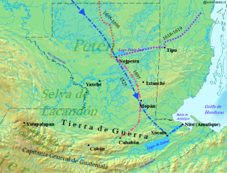
Principal settlements, neighbours and trading partners of the Manche Ch'ol
The Manche Ch'ol inhabited the southern Petén Basin, southern Belize, and the area around Lake Izabal.[1] Their territory consisted of tropical rainforest upon a low-lying limestone plain, crossed by fast-flowing rivers. It also featured small areas of savannah and extensive swamps. The Manche Ch'ol occupied a frontier region between the jurisdictions of the Spanish colonial authorities in Yucatán and Guatemala.[10] The Manche Ch'ol had frequent contact with the inhabitants of Cahabón, to the southwest, which continued after Cahabón was incorporated into the Spanish Empire. The Manche Ch'ol were bordered to the north by the Mopan Maya and to the west by the Acala Maya, who were probably another Ch'ol-speaking group.[11] Further west were the Lakandon Ch'ol,[12] occupying land around the tributaries of the upper Usumacinta River.[13] To the northwest of the Manche Ch'ol were the Itza,[14] with their territory centered upon their island capital of Nojpetén, upon Lake Petén Itzá.[15] To the east, the Manche Ch'ol bordered the Caribbean Sea, and in the 17th century Dominican friar Joseph Delgado mentioned that the Manche Ch'ol had settlements scattered along the Caribbean coast almost as far north as Bacalar,[16] now within the borders of Quintana Roo state in southeastern Mexico.[17] Settlements on the Caribbean coast in the early 17th century included Yaxhal, Paliac, Campin and Tzoite.[18] There were further towns in the Cancuén River drainage, including Manche (renamed San Miguel Manché by the Spanish), Chocahau, Yaxha (colonial San Pablo Yaxhá) and Yol (colonial Santo Domingo Yol).[19] The closest Manche town to colonial Verapaz was Tzalac (referred to as San Lucas Salac by the Spanish), 30 kilometres (19mi) from Cahabón.[20] This was a large Manche settlement on the Sarstoon River, close to the Gracias a Díos rapids.[21]
The Petén Basin is a geographical subregion of Mesoamerica, primarily located in northern Guatemala within the Department of El Petén, and into Campeche state in southeastern Mexico.
Limestone is a carbonate sedimentary rock that is often composed of the skeletal fragments of marine organisms such as coral, foraminifera, and molluscs. Its major materials are the minerals calcite and aragonite, which are different crystal forms of calcium carbonate (CaCO3). A closely related rock is dolostone, which contains a high percentage of the mineral dolomite, CaMg(CO3)2. In fact, in old USGS publications, dolostone was referred to as magnesian limestone, a term now reserved for magnesium-deficient dolostones or magnesium-rich limestones.
A savanna or savannah is a mixed woodland grassland ecosystem characterised by the trees being sufficiently widely spaced so that the canopy does not close. The open canopy allows sufficient light to reach the ground to support an unbroken herbaceous layer consisting primarily of grasses.
Society
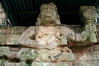
Men either went naked or wore cloths covering their lower regions; women wore fine skirts woven from cotton, and some used a fine white cloth to cover their head and chest. The Manche Ch'ol, based on their distinctive attire, in particular their turban-style headdresses, were probably descended from the Classic period inhabitants of the region; similar headdresses were illustrated in Classic Maya art from Nim Li Punit and such headdresses were restricted to the southeastern Maya lowlands and were used at cities such as Copán, Quiriguá, and their satellites.[22] Manche Ch'ol men grew their hair long; they were forced to cut it short upon their evangelisation and this caused much ill-feeling. [23]
Nim Li Punit is a Maya Classic Period site in the Toledo District of the nation of Belize, located 40 kilometres north of the town of Punta Gorda, at 16° 19' N, 88° 47' 60W. Nim Li Punit is sometimes known as Big Hat or Top Hat; the name is Kekchi Maya for "Big Hat", referring to the large elaborate head-dress on a stela sculpture found on site depicting one of the site's ancient kings.
Copán is an archaeological site of the Maya civilization in the Copán Department of western Honduras, not far from the border with Guatemala. It was the capital city of a major Classic period kingdom from the 5th to 9th centuries AD. The city was in the extreme southeast of the Mesoamerican cultural region, on the frontier with the Isthmo-Colombian cultural region, and was almost surrounded by non-Maya peoples.
Quiriguá is an ancient Maya archaeological site in the department of Izabal in south-eastern Guatemala. It is a medium-sized site covering approximately 3 square kilometres (1.2 sq mi) along the lower Motagua River, with the ceremonial center about 1 km (0.6 mi) from the north bank. During the Maya Classic Period (AD 200–900), Quiriguá was situated at the juncture of several important trade routes. The site was occupied by 200, construction on the acropolis had begun by about 550, and an explosion of grander construction started in the 8th century. All construction had halted by about 850, except for a brief period of reoccupation in the Early Postclassic. Quiriguá shares its architectural and sculptural styles with the nearby Classic Period city of Copán, with whose history it is closely entwined.
The Manche Ch'ol practised polygamy; converted Manche men were forced to give up all their wives except one. This was said to have caused such distress among some Manche men relocated to the Guatemalan Highlands that they were reported to have died. [23]
The Manche Ch'ol subsisted upon a maize-based diet; maize was mostly consumed in liquid form, such as in posole, and was probably eaten as tamales. The Manche diet also included beans, chilli, sweet potato and turkey. Plantain and sugar cane were introduced to the Manche after European contact.[23]
The Manche Ch'ol used a variation of the Maya calendar, using a 365-day year divided into eighteen 20-day "months" and ending with a 5-day unlucky period. [23] They worshipped a number of nature-based Maya deities, particularly gods of mountains and dangerous mountain passes, gods of rivers and whirlpools, and of crossroads. One named god was Escurruchan or Xcarruchan, a mountain god that was said to inhabit a mountain top close to the Gracias a Díos waterfall on the Sarstoon River.[24] On top of the mountain was a well-kept plaza with a fire that was kept permanently lit so travellers could make offerings of copal incense. Another mountain god was called Vatanchu, which translates as "straight god", who inhabited a peak on the road from Chulul to Manche.[25] The Manche Ch'ol god of death and the underworld was called Cizin.[23] In 1635 Martín Tovilla, governor of Verapaz, related that the principal gods of the Manche were called Canam, Man, and Chuemexchel.[26] He reported that Manche priests dressed in finely painted vestments fashioned from tree bark. Priests were served during rituals by young women wearing feathers, garlands and necklaces.[27] The Manche offered sacrifices to their deities that included copal incense, turkeys and human blood, both from personal bloodletting and from human sacrifice.[23]
The Manche Ch'ol lacked a complex political organisation, and possessed no large towns within their territory. Their largest settlement was Manche itself, with about one hundred multi-family houses.[28]Manche was also the name of the principal lineage at Manche and this lineage was the origin of the populations of the other Manche Ch'ol towns.[29]Nito was another principal settlement, and an important port for maritime trade that maintained strong links with places as far away as the province of Acalan in what is now southern Campeche in Mexico.[30] Otherwise, the Manche Ch'ol lived in generally small settlements governed by one or more chieftains; they were less politically complex than their Lakandon and Itza neighbours, and were not ruled by a principal king or chieftain. They grew relatively little maize, rather concentrating their agricultural production upon the prestige crops of cacao, annatto and vanilla.[31] All the main settlements, both on the coast and inland, were noted for their prodigious cacao and annatto plantations.[19]
The Manche Ch'ol were integrated into a regional trade network that included their Itza and Lakandon Ch'ol neighbours, and involved the exchange of Manche produce such as cacao, annatto and vanilla for salt, the only Maya source of which was controlled by the Itza after the Spanish conquest of the province of Acalan.[31] This trade monopoly was maintained by force on the part of the Itza, who vigorously ensured that the Manche Ch'ol remained subservient to them.[31] After the Manche towns on the coast of Belize fell under Spanish control in the 16th century, they continued to have close links with the independent inland Manche settlements.[18] Trade continued and intermarriage was common.[19] The towns in the Cancuén River drainage traded via land and riverine routes with both the independent Itza (notably with Nojpetén) and with colonial Verapaz (principally with Cobán and Cahabón).[32]
There were two main trade routes used by the Manche Ch'ol; the first went north along the Mopan River to Chacchilan, then overland to Nojpetén. The second followed the Cancuén River to Yol, and there joined the Pasión River northwards, leaving the river when it turned west and continuing overland to Nojpetén.[19] Xocmo, on the Sacapulas River, was a trading port where the Manche and Lakandon Ch'ols met to trade cacao and annatto. Xocmo had a major fair, still taking place as late as 1676, where traders arrived from various colonial and independent settlements; these included Nojpetén and the towns of Cobán, San Agustín Lanquín and Sacapulas in colonial Verapaz.[32] The Chols traded cacao and annatto into the encomienda towns of Verapaz in exchange for metal tools (particularly axes and machetes) and salt.[33] Other products traded to the Manche by the Q'eqchi' of colonial Verapaz included cotton textiles and quetzal feathers.[34] The Q'eqchi' used this trade to supply products demanded by their Spanish overlords under the repartimiento system.[35] The Manche produced a number of products for trade, manufactured from resources in the southern Maya Mountains of Belize; these included blowguns, bows and arrows, finely sculpted greenstone axes, hammocks, manos and metates, pottery, and cane, all of which were traded across the southern Maya region.[36]
Spanish contact
ConquistadorHernán Cortés passed through Manche Ch'ol territory in 1525, and described it as sparsely populated.[37] In the 16th century, the coastal towns of Campin and Tzoite were given in encomienda to Hernando Sánchez de Aguilar; they fell within the jurisdiction of colonial Bacalar,[18] on the Yucatán coast near Chetumal.[38] Although some Manche Ch'ols visited the Dominican friars in Cobán, Verapaz, in 1564,[39] the central Manche were not contacted by the Spanish again until 1603, when Dominican missionaries first attempted to evangelise them, and started to gather the scattered inhabitants into towns.[28] In the second half of the 16th century, the still-independent Manche Ch'ol became a refuge for Christianised Maya living under Spanish domination in Verapaz, who wished to escape and live as apostates among them and their Lakandon Ch'ol neighbours.[40] In 1596, Dominican friar Juan Esguerra reported seeing eleven Manche traders in Cahabón; he claimed that the Manche Ch'ol were frequent visitors to the town. In 1600 the regular presence of Manche Ch'ol traders in Cahabón was again reported, and they were said to arrive in greater numbers for the town's festivities in honour of its patron saint.[20] Friar Esguerra complained in 1605 of the great number of Christianised Q'eqchi' Maya of Cahabón that were fleeing the town to live as apostates among the Manche Ch'ol.[41]
By 1606 the missionaries had concentrated many Manche Ch'ols in nine new mission towns, and had started to penetrate the territory of the neighbouring Mopan Maya, who were on the borders of the fiercely independent Itza of central Petén.[39] By 1628 the Dominicans were tending to 6,000 Maya in the part of Manche Ch'ol territory that they had gained access to. This figure included some apostate refugees from Spanish-controlled Cahabón. Estimates of the total Manche Ch'ol population in the mid-17th century vary from 10,000 to 30,000, with prominent 20th-century Mayanist J. Eric S. Thompson preferring the lower figure as opposed to the high-end estimates by 17th-century chroniclers.[28] The Dominican penetration of Mopan territory alarmed the Itza, who started to harass the Manche Ch'ol, driving them away from the mission towns.[39]
In spite of the Dominicans' successes among the Manche in the early 17th century, they suffered a serious setback in the early 1630s when the Itza and Mopan attacked the Manche Ch'ol mission towns, driving out the Dominicans for decades.[42] The Dominicans returned in the 1670s and were able to re-establish several missions in the region.[42] In the late 17th century, the Spanish friars complained of the infidelity of the Manche; that they were quick to adopt Christianity and equally quick to abandon it. Friar Francisco Gallegos complained that trying to concentrate the Manche in mission towns was "like keeping birds in the forest without a cage".[41] Due to the historical links between the Manche Ch'ol and the inhabitants of Spanish Cahabón, the Spanish colonial authorities used the Maya inhabitants of Cahabón as guides, interpreters and lay preachers in their attempts to bring the Manche within the empire.[43] By the 1670s the Manche Ch'ol were in a difficult position, on the one side forced to bow to Itza trade demands under the threat of armed reprisals, and on the other side forced into extortionate trade with the Spanish encomienda towns. In the late 1670s, Sebastián de Olivera, alcalde mayor (governor) of Verapaz, imposed compulsory trade prices upon the Manche Ch'ol, forcing one town to buy 70 machetes at 2.5 times the going price, paid in cacao.[44] Refusal to trade was met with violence, and if the Manche could not afford the price demanded then Olivera's representatives would seize goods, clothing, poultry and previously traded metal tools.[45] In 1684 three Franciscan friars were killed during an attempt to evangelise the inhabitants of Paliac.[46] The three missionaries had been accompanying a Spanish expedition to collect valuable cacao; the expedition is likely to have involved considerable Spanish violence.[47] It is likely that the friars were sacrificed by cutting out their hearts.[46]
Extinction
In 1678 the Manche Ch'ol population was devastated by disease; in the area around the town of San Lucas Tzalac it killed every child under six years old and almost all of those under the age of ten. Total deaths, including adults, numbered over 400 and the epidemic prompted all the Manche Ch'ol in the affected region to abandon the mission towns and flee into the forest.[28] The Spanish made a number of further attempts to pacify the Manche Ch'ol, but these were ultimately unsuccessful, and the Manche Ch'ol rebelled in 1689.[42] In that year many Manche Ch'ol were forcibly relocated to the Urrán Valley in the highlands, resulting in the abandonment of many of the Manche orchards; this eventually led to the collapse of the regional trade network that by then had been fully linked with colonial Guatemala and supplied it with unknown quantities of cacao.[48]
In 1694, two Franciscan friars set out from Guatemala to see if they could succeed where the Dominicans had failed.[49]Antonio Margil and Melchor López left Cobán in August 1693 to seek out the hostile Lakandon Ch'ols in the depths of the rainforest.[50] Antionio Margil had already spent two years among the Manche Ch'ol.[51] Although they found the Lakandon, the mission was a failure and the friars were forced to flee.[50] Disappointed by their failure, in April 1694 the friars wrote a letter to the president of the Audiencia Real of Guatemala, Jacinto de Barrios Leal, stating their belief that any further peaceful attempts at converting the Ch'ol peoples were pointless, and that the time had come for military action.[52]
The conquering Spanish carried out several operations to relocate the Manche to Alta Verapaz, with their relocation being completed in 1697, a short time after the Spanish finally defeated their Itza Maya neighbours to the northwest.[53] Most of the surviving Manche Ch'ol were forcibly resettled in the Guatemalan Highlands, in the villages of El Chol and Belén, in the Urran Valley near Rabinal. The resettled Manche Ch'ol suffered from the abrupt change of climate from tropical lowland rain forest to the cold highlands. They were often not provided with suitable clothing by their Spanish overlords, and many died.[28] The depopulation of the Manche and Lakandon Ch'ol lands, and the resulting collapse of long-standing trade routes, resulted in the gradual impoverishment of colonial Verapaz.[35]
In 1699 a Spanish expedition under the command of sergeant Martín de Montoya was sent from the Spanish garrison at Nuestra Señora de los Remedios y San Pablo, Laguna del Itza (formerly Nojpetén) to investigate Indian activity in the former Ch'ol and Mopan territories.[54] He found evidence that there were still surviving Maya in all the lands he crossed, as evidenced by the carefully tended cacao and vanilla orchards. At this time there were said to be 400 relocated Maya from the same area living in Belén.[48]
By 1710 the population of Manche Ch'ol in Belén had fallen to just four; everyone else had died as a result of disease, hunger and melancholy.[48] By 1770 the Manche Ch'ol were all but extinct; their original territory had been abandoned and had reverted to wilderness, and the few survivors relocated to the highlands numbered not more than 300 in the whole Urran Valley, where there were almost as many Spanish and ladinos.[28] Many Manche Ch'ol in Verapaz were absorbed into the expanding Q'eqchi' Maya population,[55] which gradually occupied the vacated Manche lands.[56] It is possible that a few Manche Ch'ol survived in the forested interior of Toledo District in Belize, to be later absorbed by incoming Q'eqchi' in the late 19th century.[57] In the very early part of the 19th century, a handful of Maya were still recorded as speaking Ch'ol in Cobán.[58]
Legacy
The highly specialised Manche production methods for annatto, cacao and vanilla were adopted by the incoming Q'eqchi' and are still applied on a small scale.[59] Among the modern-day Q'eqchi', a tradition still exists that these orchards belong to their ancestors, the ch'olcuink spirits, who lack salt and swap cacao for it.[60]
The Spanish conquest of Yucatán was the campaign undertaken by the Spanish conquistadores against the Late Postclassic Maya states and polities in the Yucatán Peninsula, a vast limestone plain covering south-eastern Mexico, northern Guatemala, and all of Belize. The Spanish conquest of the Yucatán Peninsula was hindered by its politically fragmented state. The Spanish engaged in a strategy of concentrating native populations in newly founded colonial towns. Native resistance to the new nucleated settlements took the form of the flight into inaccessible regions such as the forest or joining neighbouring Maya groups that had not yet submitted to the Spanish. Among the Maya, ambush was a favoured tactic. Spanish weaponry included broadswords, rapiers, lances, pikes, halberds, crossbows, matchlocks and light artillery. Maya warriors fought with flint-tipped spears, bows and arrows and stones, and wore padded cotton armour to protect themselves. The Spanish introduced a number of Old World diseases previously unknown in the Americas, initiating devastating plagues that swept through the native populations.
The Itza are a Guatemalan people of Maya affiliation. They inhabit the Petén department of Guatemala in and around the city of Flores on Lake Petén Itzá.
The Spanish conquest of Guatemala was a protracted conflict during the Spanish colonization of the Americas, in which Spanish colonisers gradually incorporated the territory that became the modern country of Guatemala into the colonial Viceroyalty of New Spain. Before the conquest, this territory contained a number of competing Mesoamerican kingdoms, the majority of which were Maya. Many conquistadors viewed the Maya as "infidels" who needed to be forcefully converted and pacified, disregarding the achievements of their civilization. The first contact between the Maya and European explorers came in the early 16th century when a Spanish ship sailing from Panama to Santo Domingo was wrecked on the east coast of the Yucatán Peninsula in 1511. Several Spanish expeditions followed in 1517 and 1519, making landfall on various parts of the Yucatán coast. The Spanish conquest of the Maya was a prolonged affair; the Maya kingdoms resisted integration into the Spanish Empire with such tenacity that their defeat took almost two centuries.
Santa Cruz El Chol is a municipality in the Baja Verapaz department of Guatemala. It is situated at 1008 m above sea level and contains about 8817 people. It covers a terrain of 140 km² and its annual festival is held from December 6-December 8.
The Qʼeqchiʼ language, also spelled Kekchi, Kʼekchiʼ, or kekchí, is one of the Mayan languages, spoken within Qʼeqchiʼ communities in Guatemala and Belize.
The Chʼoltiʼ language is an extinct Mayan language which was spoken by the Manche Chʼol people of eastern Guatemala and southern Belize. The post-colonial stage of the language is only known from a single manuscript written between 1685 and 1695 which was first studied by Daniel Garrison Brinton. Chʼoltiʼ belongs to the Choʼlan branch of the Mayan languages and is closely related to Chontal and especially Chʼortiʼ. The Chʼoltiʼ language has become of particular interest for the study of Mayan Hieroglyphs since it seems that most of the glyphic texts are written in an ancient variety of Chʼoltiʼ called Classic Chʼoltiʼan or Classic Maya by epigraphers and which is thought to have been spoken as a prestige dialect throughout the Maya area in the Classic Era.
Qʼeqchiʼ are a Maya people of Guatemala and Belize. Their indigenous language is the Qʼeqchiʼ language.
The Spanish conquest of the Maya was a protracted conflict during the Spanish colonisation of the Americas, in which the Spanish conquistadores and their allies gradually incorporated the territory of the Late Postclassic Maya states and polities into the colonial Viceroyalty of New Spain. The Maya occupied a territory that is now incorporated into the modern countries of Mexico, Guatemala, Belize, Honduras and El Salvador; the conquest began in the early 16th century and is generally considered to have ended in 1697.
The ChʼolanAKACholan–Tzeltalan languages are a branch of the Mayan family of Mexico. These languages break into six sections being Cholan and Tzeltalan. Cholan has then two subsections being Western Cholan and Chʼoltiʼan; these composing the two larger sections of slight linguistic differences portrayed by Kuryłowicz's Fourth Law of Analogy. The language Tzeltalan also breaks up into sections; Tzendal, Tzotzil, and Wastekan. These subsections differ by similar linguistic differences.
The Spanish conquest of Petén was the last stage of the conquest of Guatemala, a prolonged conflict during the Spanish colonisation of the Americas. A wide lowland plain covered with dense rainforest, Petén contains a central drainage basin with a series of lakes and areas of savannah. It is crossed by several ranges of low karstic hills and rises to the south as it nears the Guatemalan Highlands. The conquest of Petén, a region now incorporated into the modern republic of Guatemala, climaxed in 1697 with the capture of Nojpetén, the island capital of the Itza kingdom, by Martín de Ursúa y Arizmendi. With the defeat of the Itza, the last independent and unconquered native kingdom in the Americas fell to European colonisers.
During the pre-Columbian era, human sacrifice in Maya culture was the ritual offering of nourishment to the gods. Blood was viewed as a potent source of nourishment for the Maya deities, and the sacrifice of a living creature was a powerful blood offering. By extension, the sacrifice of a human life was the ultimate offering of blood to the gods, and the most important Maya rituals culminated in human sacrifice. Generally only high status prisoners of war were sacrificed, with lower status captives being used for labour.
The Lakandon Chʼol were a former Chʼol-speaking Maya people inhabiting the Lacandon Jungle in what is now lowland Chiapas in Mexico and the bordering regions of northwestern Guatemala, along the tributaries of the upper Usumacinta River and the foothills of the Sierra de los Cuchumatanes.
The Peten Itza kingdom was a kingdom centered on the island-city of Nojpetén on Lake Peten Itza.
The Acala Chʼol were a former Chʼol-speaking Maya people who occupied a territory to the west of the Manche Chʼol and east of the Chixoy River in what is now the Alta Verapaz Department of Guatemala. The Acala should not be confused with the people of the former Maya territory of Acalan, near the Laguna de Terminos in Mexico.
The Chinamita or Tulumkis were a Mopan Maya people who occupied a territory in the eastern Petén Basin and western Belize between the Itza of Nojpetén, within the borders of modern Guatemala, and their allies at Tipuj, now in Belize. In the early 17th century, the Chinamita probably occupied a territory along the Mopan River south of the Yaxhá and Sacnab lakes in Petén, and in neighbouring portions of Belize. In 1698, after the fall of Nojpetén to the Spanish, the Itza told the Spanish that the Chinamita had territory nine days to the east of the Itza capital.
The Spanish conquest of Chiapas was the campaign undertaken by the Spanish conquistadores against the Late Postclassic Mesoamerican polities in the territory that is now incorporated into the modern Mexican state of Chiapas. The region is physically diverse, featuring a number of highland areas, including the Sierra Madre de Chiapas and the Montañas Centrales, a southern littoral plain known as Soconusco and a central depression formed by the drainage of the Grijalva River.
Domingo de Vico was a Spanish Dominican friar during the Spanish conquest of Chiapas and the conquest of Guatemala in the 16th century. He was originally from Jaén. Chronicler Antonio de Remesal recorded that de Vico studied theology in Úbeda and finished his studies in the San Esteban convent in Salamanca.
The history of Maya civilization is divided into three principal periods: the Preclassic, Classic and Postclassic periods; these were preceded by the Archaic Period, which saw the first settled villages and early developments in agriculture. Modern scholars regard these periods as arbitrary divisions of chronology of the Maya civilization, rather than indicative of cultural evolution or decadence. Definitions of the start and end dates of period spans can vary by as much as a century, depending on the author. The Preclassic lasted from approximately 2000 BC to approximately 250 AD; this was followed by the Classic, from 250 AD to roughly 950 AD, then by the Postclassic, from 950 AD to the middle of the 16th century. Each period is further subdivided:
Caso Barrera, Laura; and Mario Aliphat Fernández (2006). "Cacao, vanilla and annatto: three production and exchange systems in the Southern Maya lowlands, XVI–XVII centuries". Journal of Latin American Geography. Austin, Texas, US: University of Texas Press. 5 (2): 29–52. doi:10.1353/lag.2006.0015. ISSN1545-2476. JSTOR25765138. OCLC356573308.(subscription required)
ITMB (2000). México South East (Map) (2nd ed.). 1:1000000. International Travel Maps. Richmond, British Columbia, Canada: ITMB Publishing. ISBN0-921463-22-7. OCLC46660694.
Jones, Grant D. (2000). "The Lowland Maya, from the Conquest to the Present". In Richard E.W. Adams and Murdo J. Macleod (eds.). The Cambridge History of the Native Peoples of the Americas, Vol. II: Mesoamerica, part 2. Cambridge, UK: Cambridge University Press. pp.346–391. ISBN0-521-65204-9. OCLC33359444.CS1 maint: Extra text: editors list (link)
Lovell, W. George (2000). "The Highland Maya". In Richard E.W. Adams and Murdo J. Macleod (eds.). The Cambridge History of the Native Peoples of the Americas, Vol. II: Mesoamerica, part 2. Cambridge, UK: Cambridge University Press. pp.392–444. ISBN0-521-65204-9. OCLC33359444.CS1 maint: Extra text: editors list (link)
Rice, Prudence M.; and Don S. Rice (2009). "Introduction to the Kowoj and their Petén Neighbors". In Prudence M. Rice and Don S. Rice (eds.). The Kowoj: identity, migration, and geopolitics in late postclassic Petén, Guatemala. Boulder, Colorado, US: University Press of Colorado. pp.3–15. ISBN978-0-87081-930-8. OCLC225875268.CS1 maint: Extra text: editors list (link)
Schwartz, Norman B. (1990). Forest Society: A Social History of Peten, Guatemala. Philadelphia, Pennsylvania, US: University of Pennsylvania Press. ISBN0-8122-1316-5. OCLC21974298.
Thompson, J. Eric S. (October–December 1938). "Sixteenth and Seventeenth Century Reports on the Chol Mayas". American Anthropologist. New Series. Wiley on behalf of the American Anthropological Association. 40 (4 (Part 1)): 584–604. doi:10.1525/aa.1938.40.4.02a00040. JSTOR661615.(subscription required)
Thompson, J. Eric S. (1966). "The Maya Central Area at the Spanish Conquest and Later: A Problem in Demography". Proceedings of the Royal Anthropological Institute of Great Britain and Ireland. Royal Anthropological Institute of Great Britain and Ireland (1966): 23–37. JSTOR3031712.(subscription required)
Thompson, J. Eric S. (1988). The Maya of Belize: Historical Chapters Since Columbus. Benque Viejo del Carmen, Belize: Cubola Productions. ISBN968-6233-03-2. OCLC19255525.
Webre, Stephen (2004). "Política, evangelización y guerra: Fray Antonio Margil de Jesús y la frontera centroamericana, 1684–1706"[Politics, Evangelisation and War: Friar Antonio Margil de Jesús and the Central American Frontier, 1684–1706]. VII Congreso Centroamericano de Historia, Universidad Nacional Autónoma de Honduras, Tegucigalpa, 19–23 July 2004. San José, Costa Rica: Universidad de Costa Rica, Escuela de Historia. Archived from the original(DOC) on 2 November 2014. Retrieved 2012-12-09.(in Spanish)
This page is based on this Wikipedia article Text is available under the CC BY-SA 4.0 license; additional terms may apply. Images, videos and audio are available under their respective licenses.