Mato Grosso Plateau

Last updated

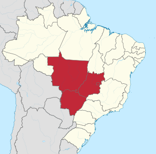
The Mato Grosso Plateau (Planalto do Mato Grosso) is a plateau in central Brazil occupying most of the state of Mato Grosso. It contains mostly savanna and woodland. It is an ancient erosional plateau that extends from the border of Goiás state westward to the Parecis plateau, which lies near the Bolivian border. In the south it gives way to floodplains called the Pantanal.

Plateau An area of a highland, usually of relatively flat terrain

In geology and physical geography, a plateau, also called a high plain or a tableland, is an area of a highland, usually consisting of relatively flat terrain, that is raised significantly above the surrounding area, often with one or more sides with steep slopes. Plateaus can be formed by a number of processes, including upwelling of volcanic magma, extrusion of lava, and erosion by water and glaciers. Plateaus are classified according to their surrounding environment as intermontane, piedmont, or continental.

Brazil Federal republic in South America

Brazil, officially the Federative Republic of Brazil, is the largest country in both South America and Latin America. At 8.5 million square kilometers and with over 208 million people, Brazil is the world's fifth-largest country by area and the fifth most populous. Its capital is Brasília, and its most populated city is São Paulo. The federation is composed of the union of the 26 states, the Federal District, and the 5,570 municipalities. It is the largest country to have Portuguese as an official language and the only one in the Americas; it is also one of the most multicultural and ethnically diverse nations, due to over a century of mass immigration from around the world.

Mato Grosso State of Brazil

Mato Grosso is one of the states of Brazil, the third-largest by area, located in the western part of the country.

The plateau is home to indigenous peoples, such as the Xavante.

Related Research Articles

Mato Grosso do Sul State of Brazil

Mato Grosso do Sul is one of the Midwestern states of Brazil. Its total area of 357,125 square kilometers, or 137,891 square miles, is roughly the same size as Germany.

Central-West Region, Brazil Region in Brazil

The Central-West or Center-West Region of Brazil is composed of the states of Goiás, Mato Grosso and Mato Grosso do Sul; along with Distrito Federal, where Brazil's national capital, Brasília, is situated. This Region is right in the heart of Brazil, representing 18.86% of the national territory.

Juruena River river in Brazil

The Juruena River is a 1,240 km (770 mi) long river in west-central Brazil, in the state of Mato Grosso.

Federal University of Mato Grosso university in Brazil

The Federal University of Mato Grosso was created in 1970. Located in the capital city of Cuiabá, it serves the entire state of Mato Grosso, Brazil. Teaching, research and extension programs are concentrated in 12 graduate programs, 63 undergraduate courses and a variable number of diploma courses in life, social and exact sciences. Nearly 20,000 students are formally enrolled. Its Medicine Faculty got, in 2007, the best average grade among Brazilian Medicine schools in the ENADE.

Sinop, Mato Grosso Municipality in Central-West, Brazil

Sinop is a city on the Brazilian state of Mato Grosso. The fourth-largest city in the state, its population in 2016 is estimated at more than 132,934 inhabitants, placing Sinop in 229th place in Brazil. It has an area of 3194.339 km ². A Sivam radar has been installed for monitoring the Amazon Basin. Also Embrapa has a branch in Sinop, the only one in the state of Mato Grosso. It is known as the Capital of Nortão, a major city of northern Mato Grosso.

Diamantino Municipality in Central-West, Brazil

Diamantino is a municipality in Mato Grosso state in Brazil. It has a population of 18,580 and is near Diamantino River. It is 1,837 feet (560 m) above sea-level, and sits at the foot of the Mato Grosso plateau. Its history dates from 1730 as a gold mining settlement. In 1746, diamonds were discovered, which made the town's population swell and prosper. The amount of diamonds was greatly overestimated, and the town population steadily declined.

Aporé Place in Goiás, Brazil

Aporé is a municipality in southwest Goiás state, Brazil. The municipality is a large producer of cattle. Aporé belongs to the Southwest Goiás Microregion.

Time in Brazil

Time in Brazil is calculated using standard time, and the country is divided into four standard time zones: UTC−02:00, UTC−03:00, UTC−04:00 and UTC−05:00.

Spatsizi Plateau Wilderness Provincial Park is a provincial park in British Columbia, Canada, protecting most of the Spatsizi Plateau, the southeasternmost subplateau of the Stikine Plateau, and the upper reaches of the basin of the Stikine River.

The Parecis plateau is a plateau in the Brazilian state of Rondônia and adjacent west-central Mato Grosso. The municipality of Parecis is located at the plateau. Several large rivers have their origin on the plateau, notably the Guaporé, Ji-Paraná, Juruena and Paraguay River. The Mato Grosso Plateau is directly to the east of Parecis.

Curvelândia is a municipality in the state of Mato Grosso in the Central-West Region of Brazil.

Santa Rita do Trivelato is a municipality in the state of Mato Grosso in the Central-West Region of Brazil.

Rondolândia Municipality in Center-West, Brazil

Rondolândia is a municipality in the state of Mato Grosso in the Central-West Region of Brazil.

Novo Mundo is a municipality in the state of Mato Grosso in the Central-West Region of Brazil.

Campo Verde is a municipality in the state of Mato Grosso in the Central-West Region of Brazil.

Primavera do Leste Municipality in Center-West, Brazil

Primavera do Leste is a municipality in the state of Mato Grosso in the Central-West Region of Brazil.

Dom Aquino Municipality in Center-West, Brazil

Dom Aquino is a municipality in the state of Mato Grosso in the Central-West Region of Brazil.

Lambari d'Oeste is a municipality in the state of Mato Grosso in the Central-West Region of Brazil.

Rio Roosevelt Ecological Station

The Rio Roosevelt Ecological Station is an ecological station in the state of Mato Grosso, Brazil.

References

    Coordinates: 15°30′00″S55°30′00″W / 15.50000°S 55.50000°W / -15.50000; -55.50000

    Geographic coordinate system Coordinate system

    A geographic coordinate system is a coordinate system that enables every location on Earth to be specified by a set of numbers, letters or symbols. The coordinates are often chosen such that one of the numbers represents a vertical position and two or three of the numbers represent a horizontal position; alternatively, a geographic position may be expressed in a combined three-dimensional Cartesian vector. A common choice of coordinates is latitude, longitude and elevation. To specify a location on a plane requires a map projection.