 Tomb at Mbutu Bandarini Ruins
 Scene at Mbutu Bandarini Ruins
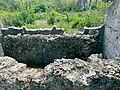
 Whats left of the old mosque at Mbutu Bandarini Ruins
 Detail of the coral stone that was used to shape the old mosque's mihrab
 Tanzania Forest Service Agency's signage next to the Mbutu Bandarini Ruins.
 Mbutu Bandarini Mosque ruin in Somangila ward of Kigamboni | |
 Mbutu Bandarini Ruins Shown within Tanzania | |
| Location | Somangila ward, Kigamboni District, Dar es Salaam Region, |
|---|---|
| Coordinates | 6°52′26.07″S39°28′18.6″E / 6.8739083°S 39.471833°E |
| Type | Settlement |
| History | |
| Material | Coral rag |
| Founded | 14th century CE |
| Abandoned | 18th century CE |
| Cultures | Swahili |
| Site notes | |
| Condition | Endangered |
| Ownership | Tanzanian Government |
| Management | Antiquities Division under the Ministry of Natural Resources and Tourism [1] |
| Architecture | |
| Architectural styles | Swahili & Islamic |
| Official name | Bandarini Ruins Historic Site |
| Type | Cultural |
| Currently neglected and vandalized | |
Mbutu Bandarini Ruins(Swahili : Magofu ya mji wa kale wa Mbutu Bandarini) is a Medieval Swahili, National Historic Site located in Somangila ward of Kigamboni District in Dar es Salaam Region of Tanzania. Despite years of indifference that led to vandalism of the site, the Tanzanian government has contracted a firm to begin repair operations as soon as feasible. [2] [3]


