Gila County is a county in the central part of the U.S. state of Arizona. As of the 2020 census, the population was 53,272. The county seat is Globe.

Gisela is an unincorporated community and census-designated place (CDP) in Gila County, Arizona, United States. The population was 570 at the 2010 census.

Star Valley is a town in Gila County, Arizona, United States, incorporated in 2005. Before incorporation, it was a census-designated place (CDP). As of the 2020 census the population of the town was 2,484.

Young is an unincorporated community and census-designated place (CDP) in Gila County, Arizona, United States. The population was 588 as of the 2020 census.

Kohls Ranch is a census-designated place (CDP) in Gila County, Arizona, United States. The population was 46 at the 2010 census.

Rye is an unincorporated community and census-designated place (CDP) in Gila County, Arizona, United States. As of the 2010 census, it had a population of 77.

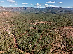
Bear Flat is a census-designated place (CDP) in Gila County, Arizona, United States. Bear Flat is located in the valley of Tonto Creek, 18 miles (29 km) east of the town of Payson. The population as of the 2010 census was 18.

Beaver Valley is a census-designated place in Gila County in the state of Arizona. Beaver Valley is located about 10 miles north of the town of Payson. The population, as of the 2010 U.S. Census, was 231.

East Verde Estates is a census-designated place in Gila County in the U.S. state of Arizona. East Verde Estates is located approximately six miles north of the town of Payson, off Arizona State Route 87. The population as of the 2010 U.S. Census was 170.

Flowing Springs is a census-designated place in Gila County in the U.S. state of Arizona. Flowing Springs is located approximately eight miles north of the town of Payson. The population was 34 at the 2020 census, down from 42 at the 2010 census.
Tonto Village is a census-designated place (CDP) in Gila County, Arizona, United States. The population was 256 at the 2010 United States Census.
Freedom Acres is a census-designated place (CDP) in Gila County, Arizona, United States. The population was 90 at the 2020 census, up from 84 at the 2010 census.
Geronimo Estates is both a census-designated place (CDP) and a populated place in Gila County, Arizona, United States. The population of the CDP was 60 at the 2010 census.
Hunter Creek is a census-designated place (CDP) in Gila County, Arizona, United States. The population was 48 at the 2010 census.
Jakes Corner is a census-designated place (CDP) in Gila County, Arizona, United States. The population was 76 at the 2010 census.
Mesa del Caballo is a census-designated place (CDP) in Gila County, Arizona, United States. The population was 765 at the 2010 census.

Oxbow Estates is a census-designated place (CDP) in Gila County, Arizona, United States. The population was 217 at the 2010 census.
Round Valley is a census-designated place (CDP) in Apache County, Arizona, United States. The population was 487 at the 2010 census.
Washington Park is a census-designated place (CDP) in Gila County, Arizona, United States. The population was 70 at the 2010 United States Census.
Whispering Pines is a census-designated place (CDP) in Gila County, Arizona, United States. It is one of two locations in Arizona with this name, the other being a populated place in Greenlee County. The population was 148 at the 2010 United States Census.