Miller Run

Last updated • 11 min readFrom Wikipedia, The Free Encyclopedia

Miller Run
Miller Run looking downstream.JPG
Miller Run looking downstream
Physical characteristics
Source 
  locationbase of a small hill in East Buffalo Township, Union County, Pennsylvania
  elevationbetween 500 and 520 feet (150 and 160 m)
Mouth  
  location
Limestone Run in Lewisburg, Union County, Pennsylvania
  coordinates
40°57′38″N76°53′00″W / 40.96046°N 76.88326°W / 40.96046; -76.88326
  elevation
430 ft (130 m)
Length1.2 mi (1.9 km)
Basin size0.87 sq mi (2.3 km2)
Basin features
ProgressionLimestone Run → West Branch Susquehanna RiverSusquehanna RiverChesapeake Bay
Tributaries 
  left"North Miller Run"

Miller Run is a tributary of Limestone Run in Union County, Pennsylvania, in the United States. It is approximately 1.2 miles (1.9 km) long and flows through East Buffalo Township and Lewisburg. [1] The watershed of the stream has an area of 0.87 square miles (2.3 km2). The stream has no officially named tributaries. It is very small and is not a perennial stream, but is impacted by stormwater flows and also has high concentrations of sediment. The stream's chemical hydrology has been significantly affected by human use. Major rock formations in its watershed include the Bloomsburg Formation, the Keyser-Tonoloway Formation, and the Wills Creek Formation.

Contents

Most of the watershed of Miller Run is owned by Bucknell University. A significant fraction of the watershed is on urban land, but there is also some forested land. The stream was being channelized as early as the 1930s. In the 21st century, a number of studies and restoration projects have been done on it. The stream is a Warmwater Fishery and six fish species have been observed within it, though only one is found in its lower reaches. It has a very low concentration of benthic macroinvertebrates.

Course

Miller Run begins at the base of a small hill in East Buffalo Township. It flows north for a short distance before turning north-northeast for several tenths of a mile. In this reach, the stream crosses US Route 15, passes through the Bucknell University campus (where it receives an unnamed tributary from the left), and enters Lewisburg. It then turns north for several hundred feet before reaching its confluence with Limestone Run. [1]

Tributaries

Miller Run has no named tributaries. [1] However, it has a tributary that is unofficially known as North Miller Run. The reach of Miller Run that is upstream of this tributary is sometimes known as South Miller Run. [2]

Hydrology and climate

Miller Run is impacted by stormwater flows and also has high concentrations of sediment. [2] [3] The lower reaches of the stream lack a perennial flow during significant portions of the year, especially during droughts. However, it was historically a perennial stream. Additionally, the stream can experience flash flooding during high flow conditions. The chemical hydrology of the stream has been significantly impacted by human use. One example of this is the fact that ion concentrations in the stream are considerably higher than ion concentrations in other similarly sized streams. [2]

The average discharge of Miller Run averages approximately 0.005 cubic meters per second (0.18 cu ft/s), but can be considerably higher, sometimes over 1 cubic meter per second (35 cu ft/s). [2] The stream exhibits highly unusual hydrologic behavior during rainstorms and snowmelts. In typical streams the discharge in the upper reaches peaks before that of the lower reaches. However, in Miller Run, this pattern is reversed and the discharge sometimes even peaks more than once. This is caused by large amounts of water flowing into it from storm drains and runoff-impervious surfaces. [2]

Miller Run has sediment loads as high as 2287 parts per million. This is more than ten times higher than the nearby Buffalo Creek, which is itself "notorious" for its sedimentation. The concentration of dissolved oxygen in Miller Run was once measured to range from over 9 to more than 11 milligrams per liter. The concentration of ammonium in the stream was less than ten milligrams per liter in both its upper reaches and its lower reaches in February 2009 and the nitrate concentration was 1.9 milligrams per liter in its upper reaches and 1.98 milligrams per liter in its lower reaches. The phosphorus concentration was less than 0.1 milligrams per liter in both reaches. The sulfate concentration was 34 milligrams per liter in the stream's upper reaches and 48 milligrams per liter in the lower reaches. The chloride concentration was 81.7 milligrams per liter in the upper reaches and 47.9 milligrams per liter in the lower reaches. [2]

In February 2009, the sodium concentration in the upper reaches of Miller Run was measured to be 32.2 milligrams per liter in the stream's upper reaches and 21.9 milligrams per liter in its lower reaches. The potassium concentration was 3.2 milligrams per liter in the upper reaches and 2.8 milligrams per liter in its lower reaches. In the stream's upper reaches, the magnesium and calcium concentrations were 9.7 and 57.9 milligrams per liter, respectively. In the lower reaches, they were 9.9 and 53.5 milligrams per liter, respectively. The concentrations of chromium, manganese, and iron were less than 0.004, 0.05, and 0.2 milligrams per liter in the upper reaches and less than 0.004, less than 0.03, and 0.23 milligrams per liter in the upper reaches. The concentrations of nickel, copper, and zinc were less than 0.005, less than 0.04, and less than 0.02 milligrams per liter in the upper reaches and the lower reaches. The arsenic, cadmium, and lead concentrations were less than 0.005, less than 0.001, and less than 0.01 milligrams per liter both reaches. [2]

During one day in April 2009, the pH of Miller Run in its lower reaches ranged from about 7.85 to 8.1. The pH of the stream in its upper reaches ranged from under 7.6 to about 7.8. The specific conductivity of the stream was between 400 and 600 micro-siemens per centimeter. The use of road salt has contributed to the sodium, chloride, and potassium concentrations in the stream during snowmelt. During one snowmelt in February 2009, the concentrations of magnesium and calcium increased early in the snowmelt before decreasing. The concentrations of nitrate and sulfate also followed this pattern. The latter two possibly came from fertilizer carried into the stream by runoff. Heavy metals were mostly found in insignificant or undetectable amounts. [2]

The average annual rate of precipitation in the watershed of Miller Run is 1.04 meters (3.4 ft). During one day in April 2009, the water temperature of the stream ranged from about 7 to 12 °C (45 to 54 °F). [2]

Geography and geology

Miller Run looking upstream Miller Run looking upstream.JPG
Miller Run looking upstream

The elevation near the mouth of Miller Run is 430 feet (130 m) above sea level. [4] The elevation of the stream's source is between 500 and 520 feet (150 and 160 m) above sea level. [1] The average elevation in the watershed is 518 feet (158 m) above sea level. The average slope is 3.12 degrees, or 11.36 meters per kilometer (60.0 ft/mi). As is the case with most streams, the gradient is highest in the stream's upper reaches. [2]

The main rock formations in the watershed of Miller Run are sedimentary rocks from the Silurian period. In the southernmost reaches of the watershed, the bedrock is red shale and sandstone of the Bloomsburg Formation. In the middle part of the watershed, there is greenish-yellow sandstone of the Wills Creek Formation, and in the northern part of the watershed, there is limestone of the Keyser-Tonoloway Formation. The average depth of the bedrock in the watershed is 1.44 meters (4.7 ft). [2]

The surficial geology in much of the watershed of Miller Run consists of unconsolidated sediment from the Pleistocene period. This is mostly a yellow-to-tan silt called loess, which has a depth of several inches to 8 feet (2.4 m). Other components of the watershed's surficial geology include gravelly till and outwash sediment. Riprap instability and streambank instability occur in the lower and middle reaches of the stream. Upstream of US Route 15, the bedload of the stream is finer than it is further downstream. At one site in the upper reaches, the average grain size is 12.08 millimeters (0.476 in). However, at a site in the lower reaches, the average grain size is 126.63 millimeters (4.985 in). [2]

Miller Run is a "tiny stream" that is closer in appearance to a drainage ditch than an actual stream. It has the characteristics of a typical suburban stream. [3] The stream was historically impacted by farming practices, as it was channelized and ditched to allow more room for crops. More recently, culverts, concrete channels, riprap, parking lots, and other developments by Bucknell University have further impacted it. There are more than a dozen obstructions along the stream. [2] There are a number of culverts on it between the Sunflower Daycare Center driveway and its confluence with Limestone Run. None of them are capable of withstanding a 100 year flood. [5] The stream is conveyed through underground pipes in some reaches. [6]

Watershed

The watershed of Miller Run has an area of 0.87 square miles (2.3 km2). [2] The stream is entirely within the United States Geological Survey quadrangle of Lewisburg. [4]

Approximately 80 percent of the watershed of Miller Run is owned by Bucknell University. Land uses in the stream's watershed include an urban college campus, a golf course, a new housing development, and suburban territory on the edge of the watershed. A total of 37.5 percent of the watershed is on urban land and 13.1 percent is on forested land. [2]

Miller Run has been described as "not appealing on the University campus" and can damage property during high flow conditions. Wetlands in the vicinity of the stream have been proposed for the purpose of stormwater retention. [2] The Music and Arts Building is situated on top of the stream at one location. Its removal has been recommended to reduce building flooding and restore the stream to a natural state. [5]

In one reach, Miller Run flows past private property that was built on an old coal ash landfill. [6]

History

Miller Run was entered into the Geographic Names Information System on October 1, 1992. Its identifier in the Geographic Names Information System is 1214632. [4]

Miller Run has historically experienced significant modifications to increase its ability to carry away stormwater. Channelization and terracing was being done in the floodplain of Miller Run as early as the 1930s. By the 1940s, a reach of the stream near the old Davis Gymnasium has been straightened and channelized, but there was still no riprap. By the 1950s, numerous culverts and extensive channelization existed along the stream. [2]

Some time in or before 2011, a major research project involving 80 students and 11 faculty members was carried out on Miller Run. The project involved GIS mapping, drone flights, sediment and water samples, and GPS measurements. The project was an extension of studies done by Allison Shaffer in 2007 and a stream restoration course taught by Bucknell University professors Craig Kochel and Matt McTammany in 2009. In 2010, the Pennsylvania Department of Environmental Protection awarded Bucknell University a $178,000 Growing Greener grant to restore the upper reaches of the stream. [3]

The Bucknell University golf course is located in the vicinity of Miller Run. [3] In 2015, a restoration project on the stream attracted some criticism from users of the golf course, as it has dried up the area and caused the driving range to look "like a desert" and business had been significantly reduced. They also criticized the scientific merit of the project, as the stream had barely any water in it. However, the Bucknell University website states that the projectwhich is supported by a $270,000 Growing Greener grant"could change the way stream monitoring and restoration is carried out statewide". [6]

Biology

Miller Run is considered by the Pennsylvania Department of Environmental Protection to be a Warmwater Fishery. In a 2009 study, 23 individuals belonging to six fish species were observed in the stream. Twenty individuals from six speciesnamely, bluegill sunfish, central stoneroller, creek chub, cutlips minnow, common shiner, and pumpkinseed sunfish were observed in the upper reaches. However, the only fish observed further downstream were three creek chubs. The significant majority of the fish observed at both sites were adults. [2]

Miller Run has an extremely low concentration of benthic macroinvertebrates in all of its reaches. On a scale of 0 to 100, various sites on Miller Run had an IBI score of 14.47 to 25.82 (values below 63 indicate an impaired waterbody). The biodiversity levels of the macroinvertebrates are also very low; the Shannon Diversity Index scores range from 0.607 to 1.726. However, only a small fraction of the macroinvertebrates belong to pollution-sensitive taxa (specifically, 25 percent in the upper reaches, 10 percent in the middle reaches, and 5 percent in the lower reaches). [2]

Common macroinvertebrate taxa in Miller Run at site MR-1 include Diptera , Amphipoda , Turbellaria , and Isopoda . Macroinvertebrate taxa in the stream at site MR-2 include Diptera, Amphipoda, Isopoda, and Oligochaeta . At the site MR-3, taxa include Diptera, Amphipoda, Turbellaria, and Isopoda, while at site MR-4, Diptera is by far the most common order. [2]

Much of the length of Miller Run has experienced a lack of riparian vegetation. [2] However, people from Bucknell University have planted and grown trees alongside the stream. [7]

Miller Run has been assessed using the method used by the Pennsylvania Department of Environmental Protection. On a scale from 0 to 240, it ranked between 59 (poor) and 122 (marginal), depending on the stream reach. The ratings became progressively poorer as the stream moved downstream through the Bucknell University campus. The concentration of Chlorophyll a in Miller Run ranges from 2 to 12 micrograms per square centimetre (6.6×10⁻⁵ to 0.000393 oz/sq ft), and varies even at a single site. The concentration generally tends to increase further downstream. [2]

See also

Related Research Articles

<span class="mw-page-title-main">Lackawanna River</span> River in Pennsylvania, United States

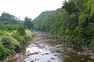
The Lackawanna River is a 42-mile-long (68 km) tributary of the Susquehanna River in Northeastern Pennsylvania. It flows through a region of the northern Pocono Mountains that was once a center of anthracite coal mining in the United States. It starts in north Wayne County, Pennsylvania and ends in east Luzerne County, Pennsylvania in Duryea, Pennsylvania. The lower reaches of the river flow through the urban areas of Scranton, which grew around its banks in the 19th century as an industrial center. Its name comes from a Lenni Lenape word meaning "stream that forks".

<span class="mw-page-title-main">Muncy Creek</span> Creek in Pennsylvania, United States

Muncy Creek is a tributary of the West Branch Susquehanna River in Sullivan County and Lycoming County, at Pennsylvania, in the United States. It is approximately 34.5 miles (55.5 km) long. The watershed of the creek has an area of 216 square miles (560 km2). The creek's discharge averages 49 cubic feet per second (1.4 m3/s) at Sonestown, but can be up to a thousand times higher at Muncy. The headwaters of the creek are on the Allegheny Plateau. Rock formations in the watershed include the Chemung Formation and the Catskill Formation.

<span class="mw-page-title-main">Towanda Creek</span>

Towanda Creek is a tributary of the Susquehanna River in Bradford County, Pennsylvania, in the United States. It is approximately 32.9 miles (52.9 km) long and flows through Canton Township, Canton, Leroy Township, Franklin Township, and Monroe Township.

<span class="mw-page-title-main">Kettle Creek (Pennsylvania)</span> Tributary of the West Branch Susquehanna River

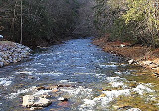
Kettle Creek is a tributary of the West Branch Susquehanna River running through Tioga, Potter, and Clinton counties, in Pennsylvania. It is slightly less than 43 miles (69 km) long. Although many streams in the Kettle Creek watershed are considered "Class A Wild Trout streams" by the Pennsylvania Fish and Boat Commission, the lower reaches of the stream experience acid mine drainage. The upper reaches of the creek are considered to be very high-quality.

<span class="mw-page-title-main">Shamokin Creek</span> River

Shamokin Creek is a tributary of the Susquehanna River in Northumberland County, Pennsylvania, in the United States. It is approximately 32.4 miles (52.1 km) long and flows through Mount Carmel, Mount Carmel Township, Coal Township, Shamokin, Ralpho Township, Shamokin Township, Snydertown, Upper Augusta Township, and Sunbury. The watershed of the creek has an area of 137 square miles (350 km2). It experiences significant impacts by abandoned mine drainage and many abandoned mine drainage discharges are in its watershed. Various other impairments also affect parts of the creek's watershed. Shamokin Creek is in the Appalachian Mountains section of the Ridge and Valley physiographic province. Rock formations consisting of sandstone, shale, and anthracite deposits occur in the watershed.

<span class="mw-page-title-main">Buffalo Creek (West Branch Susquehanna River tributary)</span> Creek in Union County, Pennsylvania

Buffalo Creek is a tributary of the West Branch Susquehanna River in Union County, Pennsylvania, in the United States. It is approximately 28.5 miles (45.9 km) long and flows through Hartley Township, Lewis Township, West Buffalo Township, Mifflinburg, Buffalo Township, Kelly Township, and Lewisburg. Its watershed has an area of 134 square miles (350 km2). It is in the ridge-and-valley province of the Appalachian Mountains. Some streams and parts of streams in the creek's watershed are high-quality cold-water fisheries. There are ten types of rock formations and eight types of soil series in the watershed. The forests in the Buffalo Creek watershed are mostly deciduous hardwood, hemlock, and pine.

Drury Run is a tributary of the West Branch Susquehanna River in Clinton County, Pennsylvania, in the United States. It is 7.71 miles (12.41 km) long and its watershed is 11.5 square miles in area, most of which is forest. The stream's tributaries are affected by acid mine drainage, as are the lower reaches of the stream itself. It begins in Tamarack Swamp and flows through Leidy Township, Noyes Township, and Renovo. Brook trout, brown trout, creek chub, and eastern blacknose dace all inhabit the stream.

<span class="mw-page-title-main">Limestone Run (Union County, Pennsylvania)</span>

Limestone Run is a tributary of the West Branch Susquehanna River in Union County, Pennsylvania. It is 5.8 miles (9.3 km) in length. The stream flows through East Buffalo Township, Buffalo Township, and Lewisburg. Ludwig Derr once constructed a mill on the stream. Limestone Run has one named tributary: Miller Run.

<span class="mw-page-title-main">West Creek (Pennsylvania)</span> Tributary in Pennsylvania, United States

West Creek is a tributary of Fishing Creek, in Columbia County and Sullivan County, in Pennsylvania, in the United States. It is 9.1 miles (14.6 km) long and flows through Davidson Township in Sullivan County and Jackson Township, Sugarloaf Township, Benton Township, and Benton in Columbia County. The water temperature of the creek ranges from 0 °C (32 °F) to 25 °C (77 °F). The discharge ranges from nearly zero to ten cubic meters per second. Rock formations in the watershed include the Trimmers Rock Formation, the Catskill Formation, and the Huntley Mountain Formation. The creek's watershed has an area of 16.6 square miles (43 km2), most of which is agricultural, forested, or urban land. A small number of dams, mills, and schoolhouses were built on West Creek in the 19th and early 20th century. West Creek has the highest level of biodiversity of any stream in the upper Fishing Creek watershed.

<span class="mw-page-title-main">Coles Creek (Pennsylvania)</span> River

Coles Creek is a tributary of Fishing Creek, in Columbia County, Pennsylvania and Sullivan County, Pennsylvania, in the United States. It is 6.0 miles (9.7 km) long and is the first named tributary of Fishing Creek downstream of where East Branch Fishing Creek and West Branch Fishing Creek meet to form Fishing Creek. The creek is on the edge of Columbia County and parts of its watershed are in Luzerne County.

<span class="mw-page-title-main">West Branch Fishing Creek</span> Tributary in Fishing Creek, Pennsylvania

West Branch Fishing Creek is one of the northernmost major tributaries of Fishing Creek in Sullivan County, Pennsylvania and Columbia County, Pennsylvania, in the United States. It is 11.1 miles (17.9 km) long and flows through Davidson Township, Sullivan County and Sugarloaf Township, Columbia County. The creek's watershed has an area of 33.5 square miles, nearly all of which is forested land.

<span class="mw-page-title-main">Nanticoke Creek</span> River in the United States of America

Nanticoke Creek is a tributary of the Susquehanna River in Luzerne County, Pennsylvania, in the United States. It is approximately 4.4 miles (7.1 km) long and flows through Hanover Township and Nanticoke. The watershed of the creek has an area of 7.57 square miles (19.6 km2). The creek has one named tributary, which is known as Espy Run. Nanticoke Creek impaired by pH and metals due to abandoned mine drainage. Abandoned mine drainage discharges in the creek's watershed include the Truesdale Mine Discharge and the Askam Borehole. The creek is located in the Northern Middle Anthracite Field and is in the Anthracite Valley Section of the ridge and valley physiographic province. The main rock formations in the watershed include the Mauch Chunk Formation, the Pottsville Group, and the Llewellyn Formation. The surficial geology consists of coal dumps, surface mining land, alluvium, Wisconsinan Outwash, Wisconsinan Till, urban land, and bedrock.

<span class="mw-page-title-main">Roaring Brook (Lackawanna River tributary)</span> River in Pennsylvania, US

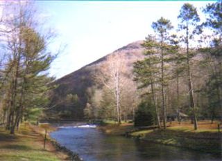
Roaring Brook is a tributary of the Lackawanna River in Lackawanna County, Pennsylvania, in the United States. It is approximately 21 miles (34 km) long and flows through Covington Township, Madison Township, Moscow, Roaring Brook Township, Elmhurst Township, Dunmore, and Scranton. The watershed of the stream has an area of 56.3 square miles (146 km2). Its named tributaries include Little Roaring Brook, Rock Bottom Creek, White Oak Run, Van Brunt Creek, Bear Brook, and East Branch Roaring Brook. It has a high level of water quality for much of its length. However, it is affected by abandoned mining land, stormwater, and other impacts in its lower reaches. Reservoirs in the watershed include the Hollister Reservoir, the Elmhurst Reservoir, and others. The stream also flows through the Nay Aug Gorge and passes over the Nay Aug Falls, which are on the National Register of Geologic Landmarks. It flows through a concrete channel in its lower reaches. The topography of the watershed contains rolling hills in its upper reaches and the mountainous land of the Moosic Mountains in its lower reaches.

Wilson Creek is a tributary of the Lackawanna River in Lackawanna County, Pennsylvania, in the United States. It is approximately 3.7 miles (6.0 km) long and flows through Fell Township. The watershed of the creek has an area of 3.82 square miles (9.9 km2). The creek is impaired by metals and pH from abandoned mine drainage. Some reaches of it also experience total flow loss. There are three discharges of acid mine drainage entering the creek: the Upper Wilson Outfall, the Lower Wilson Outfall, and the Molensky Slope Outfall. The watershed of the creek is in the Appalachian Mountain section of the Ridge and Valley physiographic province. The main rock types in the watershed are interbedded sedimentary rock and sandstone. The creek flows past areas of disturbed mining land.

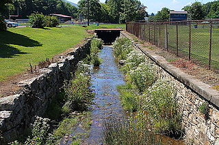
Clarks Creek is a tributary of the Lackawanna River in Wayne County, Pennsylvania, in the United States. It is approximately 2.2 miles (3.5 km) long and flows through Clinton Township. The watershed of the creek has an area of 3.37 square miles (8.7 km2). The creek has no named tributaries, but does have two unnamed tributaries. It is not considered to be impaired. The pH of the creek is slightly acidic and the concentration of water hardness is 12 milligrams per liter. Metals such as magnesium, calcium, chromium, manganese, iron, nickel, copper, zinc, cadmium, aluminum, lead, and arsenic have been observed in the creek's waters in various amounts. It is a freestone stream in the Lackawanna Valley. The surficial geology in its vicinity mainly consists of Wisconsinan Till, Wisconsinan Ice-Contact Stratified Drift, fill, surface mining lands, and bedrock.

<span class="mw-page-title-main">South Branch Tunkhannock Creek</span> River

South Branch Tunkhannock Creek is a tributary of Tunkhannock Creek in Lackawanna County and Wyoming County, in Pennsylvania, in the United States. It is approximately 22.5 miles (36.2 km) long and flows through Scott Township, Benton Township, North Abington Township, and La Plume Township in Lackawanna County and Clinton Township, Factoryville, and Tunkhannock Township in Wyoming County. The watershed of the creek has an area of 98.3 square miles (255 km2). The creek's named tributaries include Trout Brook, Ackerly Creek, and Kennedy Creek. South Branch Tunkhannock Creek is not designated as an impaired waterbody and has relatively good water quality.

<span class="mw-page-title-main">Zerbe Run</span> Stream in central Pennsylvania

Zerbe Run is a tributary of Mahanoy Creek in Northumberland County, Pennsylvania, in the United States. It is approximately 8.3 miles (13.4 km) long and flows through Coal Township, Zerbe Township, and Little Mahanoy Township. The watershed of the stream has an area of 13.1 square miles (34 km2). Part of the stream is impaired by abandoned mine drainage, but its upper reaches are not impacted by mining. Several mine drainage discharges occur within the watershed. The stream is not far from the Western Middle Anthracite Field.

<span class="mw-page-title-main">Crab Run (Mahanoy Creek tributary)</span> River

Crab Run is a tributary of Mahanoy Creek in Schuylkill County, Pennsylvania, in the United States. It is approximately 2.5 miles (4.0 km) long and flows through Barry Township. The watershed of the stream has an area of 3.50 square miles (9.1 km2). Despite being listed as impaired by abandoned mine drainage, the stream is not impacted by this; no mining has been done in its watershed. However, some stream reaches in its watershed do experience agricultural impacts. The stream is not far from the Western Middle Anthracite Field. Its watershed is designated as a Coldwater Fishery and a Migratory Fishery. As of 2001, the stream contains macroinvertebrates, but no fish.

Lost Creek is a tributary of Shenandoah Creek in Schuylkill County, Pennsylvania, in the United States. It is approximately 1.3 miles (2.1 km) long and flows through West Mahanoy Township. The watershed of the creek has an area of 1.32 square miles (3.4 km2). The creek is an ephemeral stream in its lower reaches and is impaired by abandoned mine drainage. It is in the Western Middle Anthracite Field. The creek has historically been used as a water supply. It is designated as a Coldwater Fishery.

Kehly Run is a tributary of Shenandoah Creek in Schuylkill County, Pennsylvania, in the United States. It is less than 2 miles (3.2 km) long and flows through West Mahanoy Township and possibly Shenandoah. The watershed of the stream has an area of 1.63 square miles (4.2 km2). The stream is located within the Western Middle Anthracite Field. A number of dams have been constructed across it. The stream is classified as a Coldwater Fishery and has macroinvertebrates, but no fish.

References

  1. 1 2 3 4 United States Geological Survey, The National Map Viewer, archived from the original on March 29, 2012, retrieved July 14, 2015
  2. 1 2 3 4 5 6 7 8 9 10 11 12 13 14 15 16 17 18 19 20 21 22 Characterization of Miller Run and Conceptual Plan for Watershed Restoration (PDF), 2009, pp. 4, 8–13, 19–20, 27–28, 34, 39–41, 43, 46, 53, 56, 59–66, 68–69, 79–80, 83, retrieved July 21, 2015
  3. 1 2 3 4 Julia Ferrante (December 7, 2011), Dozens of students, faculty collaborate to restore local creek , retrieved July 14, 2015
  4. 1 2 3 Geographic Names Information System, Feature Detail Report for: Miller Run , retrieved July 14, 2015
  5. 1 2 Bucknell University, The Master Plan A Vision for Bucknell Appendices (PDF), p. 51, retrieved July 22, 2015[ dead link ]
  6. 1 2 3 Justin Strawser (May 29, 2015), "Golfers irked by stalled creek restoration project", The Daily Item , retrieved July 22, 2015
  7. "Coming Events", Mifflinburg Telegraph , p. 4, April 26, 2012, retrieved July 22, 2015