Google Maps identifies an irregularly shaped area labeled "Miracle Mile" that runs from Ogden Drive on the west to Citrus Avenue and La Brea Avenue on the east. The area is roughly bordered on the north by 4th Street and on the south by 12th Street.[5]
History
Postcard, circa 1930 to 1945
In the early 1920s, Wilshire Boulevard west of Western Avenue was an unpaved farm road, extending through dairy farms and bean fields. Developer A. W. Ross saw potential for the area and developed Wilshire as a commercial district to rival downtown Los Angeles. The "Miracle Mile" nickname first appeared in local newspapers on January 27, 1929.[6]
The Miracle Mile development was initially anchored by the May Company Department Store with its landmark 1939 Streamline Moderne building on the west[7] and the E. Clem Wilson Building on the east, then Los Angeles's tallest commercial building. The Wilson Building had a dirigible mast on top and was home to a number of businesses and professionals relocating from downtown. The success of the new alternative commercial and shopping district negatively affected downtown real estate values, and triggered development of the multiple downtowns that characterize contemporary Los Angeles.
Ross's insight was that the form and scale of his Wilshire strip should attract and serve automobile traffic rather than pedestrian shoppers.[6] He applied this design both to the street itself and to the buildings lining it. Ross gave Wilshire various "firsts," including dedicated left-turn lanes and timed traffic lights, the first in the United States. He also required merchants to provide automobile parking lots, all to aid traffic flow. Major retailers such as Desmond's,[6]Silverwoods, May Co., Coulter's, Harris and Frank, Ohrbach's, Mullen & Bluett, Phelps-Terkel, Myer Siegel, and Seibu eventually spread down Wilshire Boulevard from Fairfax to La Brea. Ross ordered that all building facades along Wilshire be engineered so as to be best seen through a windshield. This meant larger, bolder, simpler signage and longer buildings in a larger scale. They also had to be oriented toward the boulevard and architectural ornamentation and massing must be perceptible at 30 MPH (50km/h) instead of at walking speed. These building forms were driven by practical requirements but contributed to the stylistic language of Art Deco and Streamline Moderne.
Ross's moves were unprecedented, a huge commercial success, and proved historically influential. Ross had invented the car-oriented urban form — what Reyner Banham called "the linear downtown" model later adopted across the United States. The moves also contributed to Los Angeles's reputation as a city dominated by the car. A sculptural bust of Ross stands at 5800 Wilshire, with the inscription, "A. W. Ross, founder and developer of the Miracle Mile. Vision to see, wisdom to know, courage to do."
As wealth and newcomers poured into the fast-growing city, Ross's parcel became one of Los Angeles's most desirable areas. Acclaimed as "America's Champs-Élysées,"[8] this stretch of Wilshire near the La Brea Tar Pits was named "Miracle Mile" for its improbable rise to prominence. Although the preponderance of shopping malls and the development in the 1960s of financial and business districts in downtown and Century City lessened the Miracle Mile's importance as a retail and business center, the area has regained its vitality thanks to the addition of several museums and commercial high-rises.[6]
Landmark buildings past and present, as well as some of the well-known businesses lining Wilshire during its main period as a retail center of Los Angeles (1930s–1960s). Architects: MWC = Morgan, Walls, & Clements, WB = Welton Becket & Associates Styles: AD = Art Deco, Ch = Churrigueresque, ︎SCR = Spanish Colonial Revival, SM = Streamline ModerneItalics indicate demolished buildings.
Miracle Mile contains two Historic Preservation Overlay Zones.
The Miracle Mile HPOZ comprises 1,347 properties. Its boundaries are Wilshire Boulevard to the north, San Vicente Boulevard to the south, La Brea Avenue to the east, and Orange Grove Avenue to the west. It is located in the city's Wilshire community plan area.[2]
The Miracle Mile North HPOZ primarily consists of single-family residences which are uniform in scale, massing and setbacks, the majority of which were built from 1924 to 1941. Its boundaries are Gardner and Detroit streets, between Beverly Boulevard and Third Street. It is located in the city's Wilshire community plan area.[3]
Transportation
Los Angeles Metro'sD Linesubway is being extended along Wilshire Boulevard to the Veterans Affairs Hospital, from its current terminus at Western Avenue in Koreatown.
In 1985, A federal ban on tunneling operations in the area was passed at the behest of the district's congressional representative Henry Waxman after an explosion, caused by the buildup of methane seeping up through the district's long-depleted oil wells, destroyed a department store. The ban was implemented despite the fact that methane deposits abound in most of Los Angeles. In late 2005, the ban was overturned, owing to tunneling techniques that make it possible to mitigate the methane concern. A westerly extension of the subway was then supported by many civic officials in Los Angeles, Beverly Hills, and Santa Monica,[22][23] the three cities through which the proposed extension runs. In early 2008, the project—which is destined to terminate in Santa Monica—received $5 billion in federal funds. In late 2008, Measure R passed, releasing $10 billion in reserve funds to start work on public transit projects in Los Angeles County. Service to three new stations, La Brea Station, Fairfax Station and La Cienega Station, is expected to begin in 2025.[24]
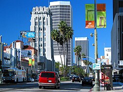
Miracle Mile viewed from south. Wilshire Blvd. runs left-to-right, lined with tall buildings.
↑ Spitz, H. May (June 13, 2004). "Map of Miracle Mile". Los Angeles Times. Retrieved February 14, 2023. The Miracle Mile district.... includes the Grove shopping complex on 3rd and expanded museums along Wilshire Boulevard
1 2 3 4 5 6 7 Gebhard, David; Winter, Robert (2003). Architectural Guidebook to Los Angeles: 37. Wilshire Boulevard District Hancock Park.
↑ "Morgan, Walls & Clements Collection". Online Archive of California. Retrieved April 22, 2024. Mullen and Bluett: Retail store building, 5570 Wilshire Blvd., Los Angeles (Job 2304) 1948 Scope and Contents Stiles O. Clements, architect. 89 drawings.
↑ "Morgan, Walls & Clements Collection". Online Archive of California. Retrieved April 22, 2024. A. W. Ross: Addition to two story Class "D" building (Phelps Terkel, lessee), SW cor. Wilshire Blvd. and Burnside Ave. ( 5550 Wilshire ), Los Angeles
↑ According to historian David Leighton, of the Arizona Daily Star newspaper the Miracle Mile in Tucson, Arizona derives its name from Los Angeles' Miracle Mile.
This page is based on this Wikipedia article Text is available under the CC BY-SA 4.0 license; additional terms may apply. Images, videos and audio are available under their respective licenses.


