
Greene is an unincorporated village and census-designated place in the western part of the town of Coventry, Rhode Island, United States. As of the 2010 census it had a population of 888. It is 2 miles (3 km) east of the Connecticut border and the same distance north of West Greenwich. The name derives from Nathanael Greene, a Rhode Island-born general in the American Revolution.

The Moosup Valley State Park Trail is a rail trail located on the railbed of a former New York, New Haven and Hartford Railroad line in the New England towns of Plainfield and Sterling in Windham County, Connecticut. The line ran from 1898 until 1968. The rail line was abandoned in the late 1960s, and was designated by the state as a multi-use trail in 1987. The trail is owned and operated by the Connecticut Department of Energy and Environmental Protection.
The Washington Secondary Rail Trail is a rail trail located in Rhode Island.

The Furnace Hill Brook Historic and Archeological District in a historic district in Cranston, Rhode Island.
The Moosup Valley Historic District is a rural, agricultural historic district in western Foster, Rhode Island. The focal center of the area is a small village where Moosup Valley Road crosses the Moosup River, and where the Moosup Valley Christian Church is located. The largest concentration of buildings in the district lie along a roughly one-mile stretch of Moosup Valley Road west of Rhode Island Route 14, with properties extending along some of the winding roads that extend from that road. The district encompasses most of the headwaters of the Moosup River. The major public buildings are the church, a vernacular Greek Revival structure built in 1864-65, and the Grange hall, built in 1926. There is also a one-room schoolhouse which was built in 1811, and later used as a library and community center.

The Sassafras Site, designated RI-55, is a prehistoric archaeological site in Albion, a village of Lincoln, Rhode Island. The site was discovered by archaeologists while surveying an area for a potential replacement for the Albion Street bridge, which spans the Blackstone River between Lincoln and Cumberland. The site encompasses a regionally significant quartz stone tool workshop.

The Woonasquatucket River Site (RI-163) is a prehistoric archaeological site in Smithfield, Rhode Island. The site contains Late Archaic artifacts, primarily stone flakes indicative of stone toolmaking activity. It is located in the George Washington Grove Wildlife Management Area, near where the Farnum Pike crosses the Woonasquatucket River.
The Ministerial Rd. Site, designated RI-781, is an prehistoric archaeological site in South Kingstown, Rhode Island. It encompasses a prehistoric Native American settlement dating to the Late Archaic period, which extends along the banks of the Chipuxet River near Ministerial Road.

Wyoming is a village and census-designated place on the Wood River in southern Rhode Island, primarily in the town of Richmond, Rhode Island, but extending north across the river into the town of Hopkinton, Rhode Island. It is the site of the Wyoming Village Historic District and a post office assigned ZIP code 02898.
The Carbuncle Hill Archaeological District encompasses a collection of archaeological sites in rural western Coventry, Rhode Island. Designated by the state as sites RI-1072 through RI-1079, this discontiguous cluster of sites has the potential to increase knowledge of prehistoric patterns of stone tool procurement, development, and use. The district was added to the National Register of Historic Places in 1985, primarily for its potential to yield further information.

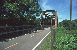
The Interlaken Mill Bridge is an historic bridge spanning the Pawtuxet River at the site of the former Arkwright and Interlaken mill complexes in Coventry, Rhode Island. The lenticular pony truss bridge was built in 1885 by the Interlaken Corporation to provide a direct connection between the mill sites, having recently (1883) acquired the Arkwright property. The trusses were manufactured by the Berlin Iron Bridge Co. of Berlin, Connecticut. The bridge is a single span measuring 92 feet (28 m) in length and just under 19 feet (5.8 m) in width, resting on stone abutments.
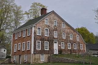
The Paine House Museum is an historic house at 7 Station Street in the village of Washington in the town Coventry, Rhode Island. The oldest portion of this large 2-1/2 story wood frame house may have been built as early as 1691 by Samuel Bennett, who was known to operate a sawmill on the nearby Pawtuxet River. The house was significantly enlarged c. 1748 by Francis Brayton. His son, Francis Jr., was granted a license to operate a tavern on the premises in 1785. The property was acquired by the Paine family in 1866, whose descendants gave it to the Western Rhode Island Civic Historical Society in 1953.

The Read School is a historic schoolhouse at 1670 Flat River Road in Coventry, Rhode Island, USA. Built c. 1831, it is one of the oldest, and the best-preserved, of Coventry's 19th-century schoolhouses. It is a rectangular wood-frame structure measuring 18 feet (5.5 m) by 24 feet (7.3 m), with a gable roof. The south side, its main facade, has a pair of doors under a ten-light transom window and a shallow entry cover. Above this is a round window, a detail echoed on the north side. It served the town as a school until 1951, and was then used for storage. It is now leased by the town to the Coventry Historical Society, who conduct tours and hold meetings there.

The Rice City Historic District is a historic district in Coventry, Rhode Island. It encompasses the 19th-century village of Rice City, extending along Plainfield Pike for several miles between Sisson Road and Gibson Hill Road in the northwestern part of Coventry. The main village center is at the junction of the Pike and Vaughn Hollow Road, and there is a former industrial and commercial center at Fairbank's Corner, the junction with Flat River Road. The architecture of the district is predominantly rural and residential, with Greek Revival and Federal style housing predominating. Rice City village is dominated by Rice Tavern, which used to serve travelers on their way to Connecticut, as well as the Rice City Church (1846), the Democrat Schoolhouse, and the Obadiah Potter House (1846), all a short way up Vaughn Hill Road. At the western edge of the district, the modern Pike alignment diverges from the historical one at Gibson Hill Road, where the foundational remnants of agricultural settlements may be found.

Aldrich Free Public Library is the public library of the Moosup section of Plainfield, Connecticut. It is located at 299 Main Street, in an architecturally significant Queen Anne building constructed in 1895 with funds given by the library's major benefactors, David L. Aldrich and Edwin Milner. The building was listed on the National Register of Historic Places in 1994.

The Forty-Seventh Camp of Rochambeau's Army is a historic military camp site in Windham, Connecticut. Located along Scotland Road a short way east of Windham Center, it was the site of a French Army camp in November 1782, when that army was en route from victory at Yorktown to Rhode Island. The camp site is considered of archaeological importance, because it can shed light on transient military camp sites, whose locations are not often known. It was listed on the National Register of Historic Places in 2003.

The Glen Falls Bridge is a historic bridge that formerly carried Brunswick Avenue over the Moosup River in Plainfield, Connecticut. Built in 1886 by the Berlin Iron Bridge Company, it is one of a shrinking number of surviving 19th-century lenticular truss bridges in the state. The bridge was listed on the National Register of Historic Places in 1999. It has been closed to all traffic for many years.

Hopkins Hollow Village is an historic district along Hopkins Hollow Road, Narrow Lane, and Perry Hill Road in Coventry, Rhode Island, United States, and West Greenwich, Rhode Island.
The Second Battle of Nipsachuck Battlefield is a historic military site in North Smithfield, Rhode Island. A largely swampy terrain, it is the site of one of the last battles of King Philip's War to be fought in southern New England, on June 2, 1676. The battle is of interest to military historians because it included a rare use in the war of a cavalry charge by the English colonists. The site was listed on the National Register of Historic Places in 2016.


