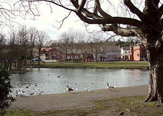
Askern is a town and civil parish within the City of Doncaster, in South Yorkshire, England. It is on the A19 road between Doncaster and Selby. Historically part of the West Riding of Yorkshire, it had a population of 5,570 at the 2011 Census. Askern was also known in for its Greyhound Stadium, which closed in 2022.

Thorne is a market town and civil parish in the City of Doncaster in South Yorkshire, England. It was historically part of the West Riding of Yorkshire until 1974. It has a population of 16,592, increasing to 17,295 at the 2011 Census.

Austerfield is a village and civil parish in the City of Doncaster, South Yorkshire, England. It is 1 mile (1.6 km) to the north-east of the market town of Bawtry on the A614 road, and adjacent to the hamlet of Newington in Nottinghamshire, close to the River Idle. The population in 2001 was 571, which fell to 536 at the 2011 Census.

Finningley is a village and civil parish in the City of Doncaster, South Yorkshire, England. Historically in Nottinghamshire, it lies on the A614 road between Bawtry and Thorne, about 6 miles south-east of Doncaster. In the 2011 census, it had a population of 1,497. The Finningley ward of Doncaster Metropolitan Borough Council covers 16.8 square miles, including the villages of Auckley, Branton, Blaxton, Hayfield and Bessacarr Grange, and part of Cantley.

Hatfield is a town and civil parish in the City of Doncaster in South Yorkshire, England. It had a population of 17,236 at the 2011 Census. The town is located on the A18 road between Doncaster and Scunthorpe, and to the west of the M18 motorway. It shares a railway station with Stainforth on the line between Goole and Scunthorpe, and Doncaster. Recorded history in the parish extends as far back as 730, when Bede wrote about the Northumbrian King, Edwin, being killed in battle in the area.

Norton is a village and civil parish in the City of Doncaster, South Yorkshire, England, on the borders with North and West Yorkshire.
Hampole is a small village and civil parish in the City of Doncaster in South Yorkshire, England, close to the border with West Yorkshire. Historically part of the West Riding of Yorkshire, the eastern boundary of the parish is marked by the Great North Road, and the parish lies in what was once the Barnsdale Forest. It had a population of 187 in 2001, increasing to 203 at the 2011 Census, which includes the neighbouring village of Skelbrooke. Hampole lies on the A638 between Doncaster and Wakefield.
Stainforth is a town and civil parish in the City of Doncaster, in South Yorkshire, England. It is around 7 miles (11 km) north-east of Doncaster, close to Hatfield and Thorne. It had a population of 6,342 in the 2001 census, reducing slightly to 6,282 at the 2011 census.

Adwick le Street is a village in the City of Doncaster, South Yorkshire, England. The Adwick ward of Doncaster Metropolitan Borough Council had a population of 15,911 at the 2011 Census. It is situated north-west of Doncaster. Under the 2011 census, the settlement had a population of 10,507.

Fenwick is a small village and civil parish in the Metropolitan Borough of Doncaster, on the border with North Yorkshire. It was historically part of the West Riding of Yorkshire until 1974. It is located at an elevation of around 6 metres above sea level and had a population of 113, increasing slightly to 121 at the 2011 Census. The northern boundary of the parish is marked by the River Went.

Auckley is a village and civil parish in the City of Doncaster in South Yorkshire, England, about five miles east of Doncaster city centre. According to the 2011 census the parish had a population of 3,745, increasing to 4,962 at the 2021 Census. The parish includes the areas of Auckley and Hayfield Green.

Balne is a village and civil parish in the Selby District of North Yorkshire in England, south of Selby. According to the 2001 census the parish had a population of 231, reducing to 224 at the 2011 census. The parish is bound to the north-east by the East Riding of Yorkshire and to the south by the Metropolitan Borough of Doncaster in South Yorkshire.

Barnburgh is a village and civil parish in the City of Doncaster in South Yorkshire, England. The village is adjacent to the village of Harlington - the parish contains both villages, and according to the 2001 census it had a population of 1,979, reducing to 1,924 at the 2011 Census. The village is located 3 miles (4.8 km) north of Mexborough, 2 miles (3.2 km) east of Goldthorpe and 8 miles (13 km) west of Doncaster itself.

Barnby Dun with Kirk Sandall is a civil parish in the Metropolitan Borough of Doncaster in South Yorkshire, England. According to the 2001 census it had a population of 8,524 and by 2011 this had risen to 8,592. The parish covers Barnby Dun and Kirk Sandall, both parts of the Doncaster urban area.
Swinefleet is a village and civil parish in the East Riding of Yorkshire, England. It is situated approximately 2 miles (3.2 km) south-east of the town of Goole on the A161 road from Goole to Crowle. It lies on the south bank of the River Ouse. According to the 2011 UK census, Swinefleet parish had a population of 787, an increase on the 2001 UK census figure of 748. The main centre of population is at the extreme north of the parish, close to the River Ouse. The southern part of the parish is part of Swinefleet and Reedness Moors, and is characterised by drainage ditches and a few farm buildings.

Hook is a village and civil parish in the East Riding of Yorkshire, England. It is situated approximately 1.5 miles (2.4 km) north-east of Goole town centre and lies on the west bank of the River Ouse.

Gilberdyke is a village and civil parish in the East Riding of Yorkshire, England. It is situated approximately 20 miles (32 km) south-east of York and 19 miles (31 km) west of Hull. Gilberdyke lies near to Howden which is 5 miles (8 km) away. It lies on the B1230 road, 1 mile (2 km) south of the M62 motorway.

Owston is a small village and civil parish in the Metropolitan Borough of Doncaster in rural South Yorkshire, England. Historically part of the West Riding of Yorkshire, the village is situated amongst mixed farmland and woodland 6 miles (9.7 km) north northwest of Doncaster, just west of the A19. It had a population of 170 in 2001, which fell to 145 according to the 2011 Census.

Kirk Smeaton is a village and civil parish in North Yorkshire, England. It is located at the southern end of the county, close to South Yorkshire and East Riding of Yorkshire. Historically the village was part of the West Riding of Yorkshire until 1974.

Edenthorpe is a village and civil parish on the eastern edge of Doncaster, South Yorkshire, England. At the 2001 census, it had a population of 4,752, increasing slightly to 4,776 at the 2011 Census. The village lies 4 miles (6.4 km) to the north east of Doncaster city centre.

