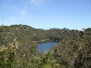
The Mount Eccles National Park, also the Budj BimNational Park, is a national park located in the Western District of Victoria, Australia. The 5,470-hectare (13,500-acre) national park is situated approximately 270 kilometres (170 mi) west of Melbourne and approximately 15 kilometres (9.3 mi) southwest of Macarthur.

Protected areas of South Australia consists of protected areas located within South Australia and its immediate onshore waters and which are managed by South Australian Government agencies. As of March 2018, South Australia contains 359 separate protected areas declared under the National Parks and Wildlife Act 1972, the Crown Land Management Act 2009 and the Wilderness Protection Act 1992 which have a total land area of 211,387.48 km2 (81,617.16 sq mi) or 21.5% of the state's area.
Victoria is the smallest mainland state in Australia. As of 2008 it contained 2,850 separate protected areas with a total land area of 39,273 km2 (15,163 sq mi). Of these, 45 were national parks, totalling 28,023 km2 (10,820 sq mi).
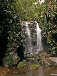
The Gondwana Rainforests of Australia, formerly known as the Central Eastern Rainforest Reserves, are the most extensive area of subtropical rainforest in the world. Collectively, the rainforests are a World Heritage Site with fifty separate reserves totalling 366,500 hectares from Newcastle to Brisbane.
Kembangan is a subzone and residential precinct located in the town of Bedok in the East Region of Singapore. It consists largely of private residential areas and a small public housing estate along Lengkong Tiga.

Mount Faber, formerly Telok Blangah Hill, is a hill about 105 metres (344 ft.) in height, located in the town of Bukit Merah in the Central Region of Singapore. It overlooks the Telok Blangah area, and the western parts of the Central Area. The summit is accessible by Mount Faber Road or Mount Faber Loop via Morse Road, but there are many footpaths or trails leading up the hill. The main paths are: Marang Trail which leads from Marang Road at the Harbourfront MRT station and the Southern Ridges Park Connector which connects from Telok Blangah Hill Park, Kent Ridge Park and Henderson Waves.

The Tangkak District is a district in Johor, Malaysia. The district capital is Tangkak Town. The district covers Tangkak Town, Tanjung Agas, Kesang, Sungai Mati, Serom, Sagil and Bukit Gambir.

Ngarkat Conservation Park is a protected area located in South Australia's south-eastern corner about 200 kilometres south east of the Adelaide city centre.

Highway 13 is a highway in the Canadian province of Saskatchewan. It runs from the Alberta border until it transitions into Highway 2 at the Manitoba border near Antler. Highway 13 is about 676 km (420 mi.) long. Highway 13 passes through Shaunavon, Assiniboia, Weyburn, Redvers and Carlyle. It is also referred to as the Red Coat Trail, as much of its length follows the route of the original historic path. A majority of the route between Wauchope and Govenlock going through the Palliser's Triangle is also referred to as the Ghost Town Trail.

Piccaninnie Ponds Conservation Park, formerly the Piccaninnie Ponds National Park, is a protected area of 862 hectares located in southeastern South Australia near Mount Gambier.

The wildlife of Singapore is surprisingly diverse despite its rapid urbanisation. The majority of fauna that still remains on the island exists in various nature reserves such as the Bukit Timah Nature Reserve and the Sungei Buloh Wetland Reserve.

Johor, formerly known as Johore, is a state of Malaysia in the south of the Malay Peninsula. Johor has land borders with the Malaysian states of Pahang to the north and Malacca and Negeri Sembilan to the northwest. Johor shares maritime borders with Singapore to the south and Indonesia to both the west and east. Johor Bahru is the capital city and the economic centre of the state, Kota Iskandar is the seat of the state government, and Muar serves as the royal town of the state. The old state capital is Johor Lama. As of the 2015 census, the state's population is 3,553,600. Johor has highly diverse tropical rainforests and an equatorial climate. The state's mountain ranges form part of the Titiwangsa Range, which is part of the larger Tenasserim Range connected to Thailand and Myanmar, with Mount Ophir being the highest point in Johor.

Smoking in Singapore was first banned in buses, cinemas and theaters in September 1970, and it was extended to indoor locations where it is frequented by most people on August 1977. After the King's Cross fire in 1987, smoking was banned in the Singapore MRT.

National scenic area (NSA) is a conservation designation used in Scotland, and administered by Scottish Natural Heritage (SNH). The designation's purpose is to identify areas of exceptional scenery and to protect them from inappropriate development. There are currently 40 national scenic areas (NSAs) in Scotland, covering 13% of the land area of Scotland. The areas protected by the designation are considered to represent the type of scenic beauty "popularly associated with Scotland and for which it is renowned". As such they tend to be mainly found in the remote, mountainous areas of Scotland, with an SNH review in 1997 noting a potential weakness of national scenic areas was that the original selection placed undue emphasis on the mountainous parts of Scotland. National scenic areas do however also cover seascapes, with approximately 26% of the total area protected by the designation being marine. The designation is primarily concerned with scenic qualities, although designated national scenic areas may well have other special qualities, for example related to culture, history, archaeology, geology or wildlife. Areas with such qualities may be protected by other designations that overlap with the NSA designation.

Kulliparu Conservation Park is a protected area in the Australian state of South Australia located on the Eyre Peninsula in the gazetted localities of Colley, Karcultaby, Mount Cooper and Mount Damper about 59 kilometres (37 mi) west of the town centre in Kyancutta.
Cocata Conservation Park is a protected area in the Australian state of South Australia located on the Eyre Peninsula in the gazetted localities of Cocata and Warramboo about 26 kilometres (16 mi) south-west of the town centre in Kyancutta.
Mount Monster Conservation Park is a protected area in the Australian state of South Australia located in the state’s south-east in the gazetted locality of Keith about 210 kilometres (130 mi) south-east of the state capital of Adelaide and about 12 kilometres (7.5 mi) south of the town centre in Keith.
Thomson Nature Park is a nature park under development in Singapore.
Gum Tree Gully Conservation Park is a protected area in the Australian state of South Australia located in the locality of Hindmarsh Tiers about 55 kilometres (34 mi) south of the state capital of Adelaide and about 6 kilometres (3.7 mi) south-east of Myponga.


