| Mount Watson | |
|---|---|
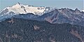
 Northwest aspect, centered | |
| Highest point | |
| Elevation | 6,220 ft (1,896 m) [1] |
| Prominence | 1,300 ft (400 m) [2] |
| Parent peak | Bacon Peak (7,070 ft) [3] |
| Isolation | 2.30 mi (3.70 km) [3] |
| Coordinates | 48°39′20″N121°34′37″W / 48.6556163°N 121.5768752°W [4] |
| Geography | |
 Mount Watson Location in Washington  Mount Watson Mount Watson (the United States) | |
 | |
| Interactive map of Mount Watson | |
| Location | Whatcom County, Washington, U.S. |
| Parent range | Cascade Range North Cascades Skagit Range |
| Topo map | USGS Bacon Peak |
| Geology | |
| Rock age | Early Cretaceous [5] |
| Rock type | Greenschist [5] |
| Climbing | |
| Easiest route | scrambling [1] |
Mount Watson is a 6,220-foot-elevation (1,900-meter) summit located in the North Cascades, in Whatcom County of Washington state. [4]