Mulberry Grove, Illinois

Last updated

Mulberry Grove, Illinois
Bond County Illinois Incorporated and Unincorporated areas Mulberry Grove Highlighted.svg
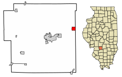
Location of Mulberry Grove in Bond County and Illinois
Illinois in United States (US48).svg
Location of Illinois in the United States
Coordinates: 38°55′28″N89°15′58″W / 38.92444°N 89.26611°W / 38.92444; -89.26611 [1]
CountryUnited States
StateIllinois
County Bond
Incorporated1857 [2]
Government
  MayorCherie Henson
Area
[3]
  Total1.02 sq mi (2.66 km2)
  Land1.02 sq mi (2.63 km2)
  Water0.01 sq mi (0.02 km2)
Elevation
[1]
548 ft (167 m)
Population
 (2020)
  Total520
  Density511.81/sq mi (197.64/km2)
Time zone UTC-6 (CST)
  Summer (DST) UTC-5 (CDT)
ZIP Code(s)
62262
Area code 618
FIPS code 17-51284
GNIS feature ID2399424 [1]
Wikimedia CommonsMulberry Grove, Illinois
Website https://mulberrygroveil.org/

Mulberry Grove is a village in eastern Bond County, Illinois, United States. The population was 520 at the 2020 census.

Contents

History

Mulberry Grove has existed under the names Bucktown, Houston and Shakerag. A post office was established in 1834, and Mulberry Grove was incorporated as a village in 1857. [2]

Geography

Mulberry Grove is located along Illinois Route 140 approximately one mile north of I-70. Greenville lies about seven miles to the west-southwest and Vandalia is about nine miles to the east-northeast. Owl Creek flows past the north side of town and joins Hurricane Creek about 1.5 mile to the east in adjacent Fayette County. [4]

According to the 2021 census gazetteer files, Mulberry Grove has a total area of 1.03 square miles (2.67 km2), of which 1.02 square miles (2.64 km2) (or 99.12%) is land and 0.01 square miles (0.03 km2) (or 0.88%) is water. [5]

Demographics

Historical population
CensusPop.Note
1900 632
1910 71613.3%
1920 7251.3%
1930 596−17.8%
1940 70217.8%
1950 7121.4%
1960 7454.6%
1970 697−6.4%
1980 7071.4%
1990 660−6.6%
2000 6711.7%
2010 634−5.5%
2020 520−18.0%
U.S. Decennial Census [6]

As of the 2020 census [7] there were 520 people, 344 households, and 175 families residing in the village. The population density was 507.32 inhabitants per square mile (195.88/km2). There were 268 housing units at an average density of 261.46 per square mile (100.95/km2). The racial makeup of the village was 93.08% White, 1.35% African American, 0.38% Native American, 0.00% Asian, 0.00% Pacific Islander, 0.38% from other races, and 4.81% from two or more races. Hispanic or Latino of any race were 0.96% of the population.

There were 344 households, out of which 29.1% had children under the age of 18 living with them, 40.70% were married couples living together, 1.16% had a female householder with no husband present, and 49.13% were non-families. 43.90% of all households were made up of individuals, and 26.45% had someone living alone who was 65 years of age or older. The average household size was 3.46 and the average family size was 2.46.

The village's age distribution consisted of 26.9% under the age of 18, 8.3% from 18 to 24, 27.7% from 25 to 44, 18.5% from 45 to 64, and 18.5% who were 65 years of age or older. The median age was 35.2 years. For every 100 females, there were 95.2 males. For every 100 females age 18 and over, there were 124.3 males.

The median income for a household in the village was $40,800, and the median income for a family was $46,823. Males had a median income of $34,063 versus $18,194 for females. The per capita income for the village was $19,672. About 14.3% of families and 31.3% of the population were below the poverty line, including 36.4% of those under age 18 and 35.7% of those age 65 or over.

Related Research Articles

<span class="mw-page-title-main">Clayton, Illinois</span> Village in Illinois, United States

Clayton is a village in Adams County, Illinois, United States. As of the 2020 census, the total population was 639 people, down from 709 at the 2010 census. It is part of the Quincy, IL–MO Micropolitan Statistical Area.

<span class="mw-page-title-main">Keyesport, Illinois</span> Village in Illinois, United States

Keyesport is a village in Bond and Clinton counties, Illinois, United States. The population was 406 at the 2020 census.

<span class="mw-page-title-main">Old Ripley, Illinois</span> Village in Illinois, United States

Old Ripley is a village in Bond County, Illinois, United States. The population was 82 at the 2020 census.

<span class="mw-page-title-main">Panama, Illinois</span> Village in Illinois, United States

Panama is a village in Montgomery and Bond counties, Illinois, United States. The population was 337 at the 2020 census.

<span class="mw-page-title-main">Pocahontas, Illinois</span> Village in Illinois, United States

Pocahontas is a village in Bond County, Illinois, United States. The population was 697 at the 2020 census.

<span class="mw-page-title-main">Chandlerville, Illinois</span> Village in Illinois, United States

Chandlerville is a village in Cass County, Illinois, United States. The population was 527 at the 2020 census.

<span class="mw-page-title-main">Pesotum, Illinois</span> Village in Illinois, United States

Pesotum is a village in Champaign County, Illinois, United States. The population was 551 at the 2010 census.

<span class="mw-page-title-main">Jeisyville, Illinois</span> Village in Illinois, United States

Jeisyville is a small village in Christian County, Illinois, United States. The population was 102 at the 2020 census.

<span class="mw-page-title-main">Maple Park, Illinois</span> Village in Illinois, United States

Maple Park is a village in DeKalb and Kane counties in the U.S. state of Illinois. The population was 1,433 at the 2020 census, up from 1,310 at the 2010 census. Maple Park was formerly known as Lodi.

<span class="mw-page-title-main">Mazon, Illinois</span> Village in Illinois, United States

Mazon is a village in Mazon Township, Grundy County, Illinois, United States. The name derives from the Potawatomi word for "nettles" (mzan). The population was 1,015 at the 2010 census. The center of population of Illinois is located in Mazon. Illinois' State Fossil, the unique and bizarre Tully Monster was first found in nearby Mazon Creek. Mazon was formerly served by the Santa Fe railway at the Mazon Depot. It was established in 1876.

<span class="mw-page-title-main">East Galesburg, Illinois</span> Village in Illinois, United States

East Galesburg is a village in Knox County, Illinois, United States. The population was 812 as of the 2010 census, down from 839 in 2000. It is part of the Galesburg Micropolitan Statistical Area.

<span class="mw-page-title-main">Troy Grove, Illinois</span> Village in Illinois, United States

Troy Grove is a village in LaSalle County, Illinois, United States. The population was 225 at the 2020 census, down from 250 at the 2010 census. It is part of the Ottawa, IL Micropolitan Statistical Area.

<span class="mw-page-title-main">Green Oaks, Illinois</span> Village in Illinois, United States

Green Oaks is a village in Libertyville Township, Lake County, Illinois, United States. Per the 2020 census, the population was 4,128.

<span class="mw-page-title-main">Schram City, Illinois</span> Village in Illinois, United States

Schram City is a village in Montgomery County, Illinois, United States. The population was 563 at the 2020 census.

<span class="mw-page-title-main">Ellis Grove, Illinois</span> Village in Illinois, United States

Ellis Grove is a village in Randolph County, Illinois, United States. The population was 328 at the 2020 census.

<span class="mw-page-title-main">Oak Grove, Illinois</span> Village in Illinois, United States

Oak Grove is a village in Rock Island County, Illinois, United States. The population was 396 at the 2010 census.

<span class="mw-page-title-main">Deer Grove, Illinois</span> Village in Illinois, United States

Deer Grove is a village in Whiteside County, Illinois, United States. The population was given as 45 in the 2010 census, down from 48 in 2000.

<span class="mw-page-title-main">Central Township, Bond County, Illinois</span> Township in Illinois, United States

Central Township is one of nine townships in Bond County, Illinois, USA. As of the 2020 census, its population was 7.968 and it contained 2,788 housing units.

<span class="mw-page-title-main">Mulberry Grove Township, Bond County, Illinois</span> Township in Illinois, United States

Mulberry Grove Township is one of nine townships in Bond County, Illinois, USA. As of the 2020 census, its population was 1,133 and it contained 569 housing units.

<span class="mw-page-title-main">Pleasant Mound Township, Bond County, Illinois</span> Township in Illinois, United States

Pleasant Mound Township is one of nine townships in Bond County, Illinois, USA. As of the 2020 census, its population was 907 and it contained 446 housing units.

References

  1. 1 2 3 U.S. Geological Survey Geographic Names Information System: Mulberry Grove, Illinois
  2. 1 2 Allan H. Keith, Historical Stories: About Greenville and Bond County, IL. Consulted on August 15, 2007.
  3. "2020 U.S. Gazetteer Files". United States Census Bureau. Retrieved March 15, 2022.
  4. Mulberry Grove, IL, 7.5 Minute Topographic Quadrangle, USGS, 1974 (1977 rev.)
  5. Bureau, US Census. "Gazetteer Files". Census.gov. Retrieved June 29, 2022.
  6. "Census of Population and Housing". Census.gov. Retrieved June 4, 2015.
  7. "Explore Census Data". data.census.gov. Retrieved June 28, 2022.