Birch Hills is a town located in Saskatchewan, Canada. It is located southeast of Prince Albert and the reserve of Muskoday First Nation. Directly to the west is the village of St. Louis, and to the east is Kinistino. It is surrounded by, but not part of, Birch Hills Rural Municipality No. 460.

The Muskoday First Nation is a First Nation band government in Saskatchewan, Canada, composed of Cree and Saulteaux peoples. The First Nation has a registered population of 1,828 people as of September 2014, of which approximately 623 members of the First Nation live on-reserve, and approximately 1204 live off-reserve. Muskoday's territory is located in the aspen parkland biome. It is bordered by the rural municipalities of Birch Hills No. 460 and Prince Albert No. 461.
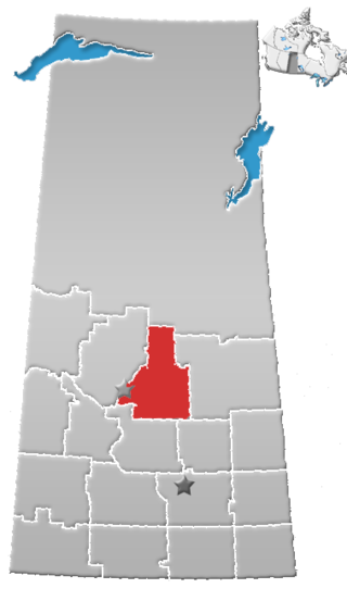
Division No. 15 is one of eighteen census divisions in the province of Saskatchewan, Canada, as defined by Statistics Canada. It is located in the north-central part of the province. The most populous community in this division is Prince Albert.
The Lac La Ronge Indian Band is a Woodland Cree First Nation in northern Saskatchewan, it is the largest Cree band government in Canada and the largest First Nation in Saskatchewan. The administrative centre of the Lac La Ronge Indian Band is located in La Ronge.
Fenton, formerly Adams Crossing, is an unincorporated community south-east of Prince Albert, Saskatchewan, Canada. It is a short distance, 13 km west from Birch Hills, Saskatchewan. Fenton is on the banks of the South Saskatchewan River, east of Halcro, Saskatchewan and south-west of the Muskoday First Nation. The Fenton Ferry is operational seasonally and hosts mainly local traffic. Fenton has a long history dating back to Anglo-Metis settlement before the North-West Rebellion. It is situated in the Aspen parkland biome.
Davis is an unincorporated community south of Prince Albert, Saskatchewan, Canada. Davis was once a village but has since shrunk to a handful of houses. It is just northwest of the Muskoday First Nation and southeast of Prince Albert. Davis was named for Senator Thomas Osborne Davis a prominent Prince Albert merchant and Liberal Party member in the late nineteenth and early twentieth century. Davis is located in the Aspen parkland biome.
The Rolling River First Nation is an Ojibwe First Nations community in Manitoba, located south of Riding Mountain National Park.

Bittern Lake 218 is an Indian reserve of the Lac La Ronge Indian Band in Saskatchewan. It is 8 kilometres east of Prince Albert National Park.

The Chief Joseph Custer Reserve is an Indian reserve of the Peter Ballantyne Cree Nation in Saskatchewan. It is located in the city of Prince Albert, making it an urban reserve.

Chief Philip Morin 232 is an Indian reserve of the Peter Ballantyne Cree Nation in Saskatchewan. It is located inside the city of Prince Albert, making it an urban reserve.

Flying Dust 105D is an Indian reserve of the Flying Dust First Nation in Saskatchewan.
Flying Dust 105E is an Indian reserve of the Flying Dust First Nation in Saskatchewan.

Gladue Lake 105B is an Indigenous reserve of the Flying Dust First Nation in Saskatchewan, Canada. It is in Township 63, Range 15, west of the Third Meridian, in the Jarvis Lake area.

Little Hills 158B is an Indian reserve of the Lac La Ronge Indian Band in Saskatchewan. It is 8 miles southwest of La Ronge, and on the south-east shore of Bigstone Lake.

Little Red River 106C is an Indian reserve of the Lac La Ronge Indian Band in Saskatchewan. It is 34 kilometres north of Prince Albert. In the 2016 Canadian Census, it recorded a population of 354 living in 88 of its 98 total private dwellings. In the same year, its Community Well-Being index was calculated at 48 of 100, compared to 58.4 for the average First Nations community and 77.5 for the average non-Indigenous community.
The Muskoday Reserve is an Indian reserve of the Muskoday First Nation in Saskatchewan. It is 19 kilometres southeast of Prince Albert. In the 2016 Canadian Census, it recorded a population of 647 living in 205 of its 217 total private dwellings. In the same year, its Community Well-Being index was calculated at 64 of 100, compared to 58.4 for the average First Nations community and 77.5 for the average non-Indigenous community.

Muskoday 99A is an Indian reserve of the Muskoday First Nation in Saskatchewan.

Wahpaton 94A is an Indian reserve of the Wahpeton Dakota Nation in Saskatchewan. It is 10 kilometres north of Prince Albert. In the 2016 Canadian Census, it recorded a population of 309 living in 70 of its 80 total private dwellings. In the same year, its Community Well-Being index was calculated at 58 of 100, compared to 58.4 for the average First Nations community and 77.5 for the average non-Indigenous community.

Wahpaton 94B is an Indian reserve of the Wahpeton Dakota Nation in Saskatchewan.
