This page is based on this
Wikipedia article Text is available under the
CC BY-SA 4.0 license; additional terms may apply.
Images, videos and audio are available under their respective licenses.

The Gulf of Saint Lawrence is the outlet of the North American Great Lakes via the Saint Lawrence River into the Atlantic Ocean. The gulf is a semi-enclosed sea, covering an area of about 226,000 square kilometres (87,000 sq mi) and containing about 34,500 cubic kilometres (8,300 cu mi) of water, which results in an average depth of 152 metres (499 ft).

The Arctic Archipelago, also known as the Canadian Arctic Archipelago, is a group of islands north of the Canadian mainland.

Oak Hills is a census-designated place (CDP) in Butler County, Pennsylvania, United States. The population was 2,333 at the 2010 census.

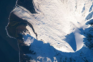
Big Ben is a volcanic massif that dominates the geography of Heard Island in the southern Indian Ocean. It is a composite cone with a diameter of approximately 25 kilometres. Its highest peak is Mawson Peak, which is 2,745 m above sea level. Much of it is covered by ice, including 14 major glaciers which descend from Big Ben to the sea. Big Ben is the highest mountain in Australian Territory, except for those claimed in the Australian Antarctic Territory. A smaller volcanic headland, the Laurens Peninsula, extends approximately 10 km to the northwest, created by a separate volcano, Mount Dixon; its highest point is Anzac Peak, at 715 m.

The Chacao Channel is located in Los Lagos Region, Chile and separates Chiloé Island from mainland Chile. The channel was created during the Quaternary glaciations by successive glaciers that flowed down from the Andes to the coast. The construction of a bridge connecting the island with the continent was discussed at government level for some time, but during the first government of Michelle Bachelet (2006–2010) it was turned down due to its high cost in comparison with other proposals that could be done to benefit islanders. Later, it was reactivated during Sebastián Piñera government, and finally auctioned

Area codes 204 and 431 are the North American telephone area codes for the Canadian province of Manitoba, encompassing the province. 204 is one of the original 86 area codes assigned in 1947 in the contiguous United States and the then-nine-province extent of Canada.
Great Spruce Head Island is a privately owned island in Penobscot Bay, Maine. It is part of the Town of Deer Isle, in Hancock County. It has long belonged to the family of the painter Fairfield Porter and his brother, photographer Eliot Porter, both of whom did creative work there. For example, Eliot's book Summer Island (1966) is a visual tribute to the island.
St Paul's High School is a co-educational, Roman Catholic comprehensive secondary school located in Pollok, Glasgow, Scotland. It was built on the site of, and using some buildings from, the former Craigbank Secondary School.
Valle de la Mocha is a plain in Chile on the north shore of the Bio-Bio River that contained the reducción of Mapuche who were transported in 1685, from Mocha Island by Governor José de Garro; from which the valley and plain took its name. Governor Domingo Ortiz de Rosas transferred the old city of Concepcion to this site from Penco after the May 25, 1751 Concepción earthquake.

Bay Tree is an unincorporated community in northern Alberta in Saddle Hills County, located on Highway 49, 100 kilometres (62 mi) northwest of Grande Prairie.
The Belle Chain Islets, originally simply the Belle Chain are a group of small islands off the north end of Saturna Island on the west side of the Strait of Georgia on the South Coast of British Columbia, Canada. The Belle Chain Islets are part of Gulf Islands National Park Reserve and are Authorized Access Only except for Lot 65 which is available for day use by boaters and kayakers.

Harlosh Island is an island in Loch Bracadale just off the coast of the Minginish and Harlosh peninsulas of Skye in Scotland.
Tasiusaq Bay is a bay in the Upernavik Archipelago in the Qaasuitsup municipality in northwestern Greenland. It is an indentation of northeastern Baffin Bay. The name of the bay derives from the name of the settlement of the same name in the bay.
Kangerlussuaq Icefjord is a fjord in the Qaasuitsup municipality in northwestern Greenland.

Landreth Glacier is the steep 2.3 km long and 600 m wide glacier on the southeast side of Imeon Range, Smith Island in the South Shetland Islands, Antarctica, which is draining southeastwards from Mount Foster between the side ridges separating it from Rupite Glacier to the north and Dragoman Glacier to the south, and flowing into Ivan Asen Cove on Bransfield Strait.
Weal is an unincorporated community in Pittsylvania County, in the U.S. state of Virginia.


