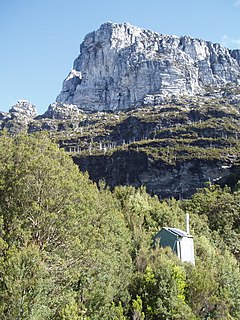
Narcissus Hut

Last updated

Narcissus Hut
Narcissus Hut.jpg
Australia Tasmania location map.svg
Red pog.svg
Narcissus Hut
Coordinates 42°0′45.1″S146°6′5.8″E / 42.012528°S 146.101611°E / -42.012528; 146.101611 Coordinates: 42°0′45.1″S146°6′5.8″E / 42.012528°S 146.101611°E / -42.012528; 146.101611
Country Australia
State/territory Tasmania
National park Cradle Mountain-Lake St Clair National Park
Construction
Built in 1935
Built by National Park Board in 1938
rebuilt 1963
Built for Hiking on Overland Track
Administration
Maintained by Tasmania Parks and Wildlife Service
Accessibility
Accessed by Foot and/or boat

Narcissus Hut is an alpine hut located in the Central Highlands of Tasmania. It was built in 1935 and rebuilt in 1963. [1]

Mountain hut building located in the mountains

A mountain hut is a building located high in the mountains, generally accessible only by foot, intended to provide food and shelter to mountaineers, climbers and hikers. Mountain huts are usually operated by an Alpine Club or some organisation dedicated to hiking or mountain recreation.

The Central Highlands is a region in Tasmania, Australia where geographical and administrative boundaries closely coincide. It is also known as The Lake Country of Tasmania.

Tasmania island state of Australia

Tasmania is an island state of Australia. It is located 240 km (150 mi) to the south of the Australian mainland, separated by Bass Strait. The state encompasses the main island of Tasmania, the 26th-largest island in the world, and the surrounding 334 islands. The state has a population of around 526,700 as of March 2018. Just over forty percent of the population resides in the Greater Hobart precinct, which forms the metropolitan area of the state capital and largest city, Hobart.

Contents

Narcissus Hut is located on Lake St Clair, on the Overland Track.

Lake St Clair (Tasmania) lake in Tasmania, Australia

Lake St Clair or leeawulenna is a natural freshwater lake located in the Central Highlands area of Tasmania, Australia. The lake forms the southern end of the Cradle Mountain-Lake St Clair National Park. It has an area of approximately 45 square kilometres (17 sq mi), and a maximum depth of 160 metres (520 ft), making it Australia's deepest lake.

Overland Track hiking trail in Cradle Mountain-Lake St Clair National Park, Tasmania, Australia

The Overland Track is one of Australia's most famous bushwalking tracks, and is crosses the Cradle Mountain-Lake St Clair National Park in Tasmania. More than nine thousand walkers each year complete the track. Officially, the track runs for 65 kilometres (40 mi) from Cradle Mountain to Lake St Clair. However, many choose to add the hike along Lake St Clair as a natural extension, bringing the length to 82 kilometres (51 mi). The track winds through terrain ranging from sheer mountains, temperate rainforest, wild rivers and alpine plains all in the Tasmanian Wilderness World Heritage Area.

Facilities

Composting toilet A type of toilet that treats human excreta by a biological process called composting

A composting toilet is a type of toilet that treats human excreta by a biological process called composting. This process leads to the decomposition of organic matter and turns human excreta into compost. It is carried out by microorganisms under controlled aerobic conditions. Most composting toilets use no water for flushing and are therefore "dry toilets".

Rainwater tank container used to collect rainwater

A rainwater tank is a water tank used to collect and store rain water runoff, typically from rooftops via pipes. Rainwater tanks are devices for collecting and maintaining harvested rain. A rainwater catchment or collection system can yield 2,358 litres (623 US gal) of water from 2.54 cm (1.00 in) of rain on a 92.9 m2 (1,000 sq ft) roof.

Rainfall Catchment Equation: Catchment Area x Event Rainfall Depth (in) x 0.623 Conversion Factor =Gallonsof Potential Rainwater Collected

*Note this equation is for U.S., imperial measurements; i.e. calculations and conversion factor is for distance in feet and inches, and volume in gallons.

Access

By foot (Overland Track)

To the north, the Overland Track follows the Narcissus river to Windy Ridge Hut, approximately three hours walk.

To the south, it skirts the southern shore of Lake St Clair for 5–6 hours, arriving at the Cynthia Bay trailhead, and the Visitors Centre.

By boat

Walkers arrive at the Lake St Clair Jetty. Lake st clair jetty.jpg
Walkers arrive at the Lake St Clair Jetty.

There is a small jetty on the lake near the hut. During the peak summer season, a ferry runs between the visitors centre and Narcissus Hut, taking 30 minutes and costing A$40.00. (2012/2013) Bookings recommended. see http://www.lakestclairlodge.com.au/about-lake-st-clair/lake-st-clair-ferry/ There is a radio to contact the ferry operator at Narcissus Hut. To pre-book call 03 62 891 137 or email

Related Research Articles

Cradle Mountain-Lake St Clair National Park Protected area in Tasmania, Australia

Cradle Mountain-Lake St Clair National Park is located in the Central Highlands area of Tasmania (Australia), 165 kilometres (103 mi) northwest of Hobart. The park contains many walking trails, and is where hikes along the well-known Overland Track usually begin. Major features are Cradle Mountain and Barn Bluff in the northern end, Mount Pelion East, Mount Pelion West, Mount Oakleigh and Mount Ossa in the middle and Lake St Clair in the southern end of the park. The park is part of the Tasmanian Wilderness World Heritage Area.

Cradle Mountain mountain

Cradle Mountain is a mountain in the Central Highlands region of the Australian state of Tasmania. The mountain is situated in the Cradle Mountain-Lake St Clair National Park.

Mount Ossa (Tasmania) mountain in Tasmania

Mount Ossa is a mountain of the Pelion Range located in the Central Highlands region of Tasmania, Australia.

Sheffield, Tasmania Town in Tasmania, Australia

Sheffield is a town 23 kilometres inland from Devonport on the north-west coast of Tasmania. Sheffield has long been the rural hub for the Mount Roland area. The Sheffield area is well known for its high quality butterfat production via dairy farming. The area is suitable for lamb and beef production. The town of Railton is nearby. At the 2016 census, Sheffield had a population of 1,552.

Frenchmans Cap mountain in Western Tasmania, located in Wilderness World Heritage area

The Frenchmans Cap is a mountain in the West Coast region of Tasmania, Australia. The mountain is situated in the Franklin-Gordon Wild Rivers National Park.

Kepler Track

The Kepler Track is a 60 km (37 mi) circular tramping track which travels through the landscape of the South Island of New Zealand and is situated near the town of Te Anau. The track passes through many landscapes of the Fiordland National Park such as rocky mountain ridges, tall mossy forests, lake shores, deep gorges, rare wetlands and rivers. Like the mountains it traverses, the track is named after Johannes Kepler. The track is one of the New Zealand Great Walks and is administered by New Zealand Department of Conservation (DOC).

Barn Bluff Mountain in Tasmania, Australia

The Barn Bluff is a mountain located in the Central Highlands region of Tasmania, Australia. The mountain is situated in the Cradle Mountain-Lake St Clair National Park at the junction of the eastern most points of the Murchison and Mackintosh river catchments.

Mount Pelion West mountain

Mount Pelion West is a mountain located in the Central Highlands region of Tasmania, Australia. The mountain is part of the Pelion Range and is situated within the Cradle Mountain-Lake St Clair National Park at the eastern most boundary of the Murchison River catchment.

Mount Pelion East mountain

Mount Pelion East is a mountain located in the Central Highlands region of Tasmania, Australia. The mountain is situated within the Cradle Mountain-Lake St Clair National Park.

Pelion Gap

Pelion Gap is the mountain pass between Mount Doris and Mount Ossa to the south and Mount Pelion East to the north through which the Overland Track in Tasmania passes.

Cathedral Mountain (Tasmania) mountain

Cathedral Mountain is a dominant mountain in the Cradle Mountain-Lake St Clair National Park in the central highlands in the state of Tasmania, Australia.

New Pelion Hut

New Pelion Hut is the largest alpine hut in the Cradle Mountain-Lake St Clair National Park in the Central Highlands of Tasmania, Australia

Old Pelion Hut

Old Pelion Hut is an alpine hut located in Cradle Mountain-Lake St Clair National Park in the Central Highlands of Tasmania. It was built for the Mount Pelion Copper Mining Company at around 1936.

Waterfall Valley Hut

Waterfall Valley Hut is located in the Cradle Mountain National Park, Tasmania, Australia. It is the most northerly of six overnight huts located along the Overland Track. It sleeps up to 32 people in a single room, which also houses tables and bench seats for cooking and eating. It is heated by a small gas heater.

Smithies Peak mountain in Tasmania, Australia

The Smithies Peak, sometimes incorrectly called Smithies Towers, is a mountain in the Central Highlands region of Tasmania, Australia. The mountain is situated in the Cradle Mountain-Lake St Clair National Park.

Pelion Range mountains in Australia

The Pelion Range is a mountain range in the Cradle Mountain-Lake St Clair National Park, Tasmania, Australia.

The Anthony Road is a major B Route in Western Tasmania, running from the Murchison Highway (A10) at Tullah to the Zeehan Highway (A10) north of Queenstown.

Tyndall Range mountains in Western Tasmania

The Tyndall Range, commonly called The Tyndalls, is a mountain range that is part of the West Coast Range located in the Western region of Tasmania, Australia.

References

  1. Boss-Walker, Ian (1964) Peaks and High Places - Cradle Mt - Lake St Clair National Park Tasmania Hobart, Scenery Preservation Board. - page 68