
Cradle Mountain-Lake St Clair National Park is located in the Central Highlands area of Tasmania (Australia), 165 kilometres (103 mi) northwest of Hobart. The park contains many walking trails, and is where hikes along the well-known Overland Track usually begin. Major features are Cradle Mountain and Barn Bluff in the northern end, Mount Pelion East, Mount Pelion West, Mount Oakleigh and Mount Ossa in the middle and Lake St Clair in the southern end of the park. The park is part of the Tasmanian Wilderness World Heritage Area.
Cradle Mountain is a locality and mountain in the Central Highlands region of the Australian state of Tasmania. The mountain is situated in the Cradle Mountain-Lake St Clair National Park.

Lake St Clair or leeawulenna is a natural freshwater lake located in the Central Highlands area of Tasmania, Australia. The lake forms the southern end of the Cradle Mountain-Lake St Clair National Park. It has an area of approximately 45 square kilometres (17 sq mi), and a maximum depth of 160 metres (520 ft), making it Australia's deepest lake.

Mount Ossa is the highest mountain in Tasmania with a summit elevation of 1,617 metres (5,305 ft) above sea level. It makes up part of the Pelion Range within Cradle Mountain-Lake St Clair National Park in the Central Highlands region of Tasmania, Australia.

The Overland Track is an Australian bushwalking track, traversing Cradle Mountain-Lake St Clair National Park, within the Tasmanian Wilderness World Heritage Area. It's walked by more than nine thousand people each year, with numbers limited in the warmer months. Officially the track runs for 65 kilometres (40 mi) from Cradle Mountain to Lake St Clair however many choose to extend it by walking along Lake St Clair for an extra day, bringing it to 82 kilometres (51 mi). It winds through terrain ranging from glacial mountains, temperate rainforest, wild rivers and alpine plains.
Frenchmans Cap is a mountain in the West Coast region of Tasmania, Australia. The mountain is situated in the Franklin-Gordon Wild Rivers National Park.

Narcissus Hut is an alpine hut located in the Central Highlands of Tasmania. It was built in 1935 and rebuilt in 1963.

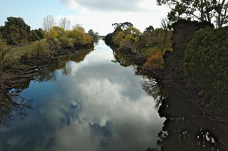
The Murchison River, part of the Pieman River catchment, is a major perennial river located in the West Coast region of Tasmania, Australia.

Barn Bluff is a mountain located in the Central Highlands region of Tasmania, Australia. The mountain is situated in the Cradle Mountain-Lake St Clair National Park at the junction of the easternmost points of the Murchison and Mackintosh river catchments.

Mount Pelion West is a mountain located in the Central Highlands region of Tasmania, Australia. The mountain is part of the Pelion Range and is situated within the Cradle Mountain-Lake St Clair National Park at the easternmost boundary of the Murchison River catchment.

Mount Pelion East is a mountain located in the Central Highlands region of Tasmania, Australia. The mountain is situated within the Cradle Mountain-Lake St Clair National Park.

Pelion Gap is the mountain pass between Mount Doris and Mount Ossa to the south and Mount Pelion East to the north through which the Overland Track in Tasmania passes.
Mount Thetis is a mountain in the Central Highlands region of Tasmania, Australia. It is part of the Pelion Range and is situated within the Cradle Mountain-Lake St Clair National Park. It is a major feature of the national park, and is a popular venue with bushwalkers and mountain climbers.
Mount Achilles is a mountain that is part of the Du Cane Range, located in the Cradle Mountain-Lake St Clair National Park in Tasmania, Australia. With an elevation of 1,353 metres (4,439 ft) above sea level, the peak is the 46th highest mountain in Tasmania.

Mount Ragoona, sometimes Mount Rogoonga, is a relatively high mountain in the southern region of the Walls of Jerusalem National Park in Tasmania, Australia. The mountain, with an elevation of 1,336 metres (4,383 ft) above sea level, is virtually surrounded by four large lakes; Myrtle, Meston, Louisa and Adelaide. The mountain rises from the shores of Lake Myrtle.

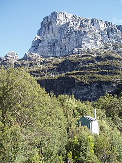
Cathedral Mountain is a dominant mountain in the Cradle Mountain-Lake St Clair National Park in the central highlands in the state of Tasmania, Australia.

Old Pelion Hut is an alpine hut located in Cradle Mountain-Lake St Clair National Park in the Central Highlands of Tasmania. It was built for the Mount Pelion Copper Mining Company at around 1936.

Waterfall Valley Hut is located in the Cradle Mountain National Park, Tasmania, Australia. It is the most northerly of six overnight huts located along the Overland Track. The new version of the hut was opened in 2020. It sleeps up to 34 people in a single room, which also houses tables and bench seats for cooking and eating. It is heated by a small gas heater.
The Forth River is a perennial river located in northwest Tasmania, Australia.
The Pelion Range is a mountain range in the Cradle Mountain-Lake St Clair National Park, Tasmania, Australia.


