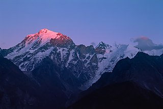
Himachal Pradesh is a state in the northern part of India. Situated in the Western Himalayas, it is one of the thirteen mountain states and is characterised by an extreme landscape featuring several peaks and extensive river systems. Himachal Pradesh is the northernmost state of India and shares borders with the union territories of Jammu and Kashmir and Ladakh to the north, and the states of Punjab to the west, Haryana to the southwest, Uttarakhand to the southeast and a very narrow border with Uttar Pradesh to the south. The state also shares an international border to the east with the Tibet Autonomous Region in China. Himachal Pradesh is also known as Dev Bhoomi, meaning 'Land of Gods' and Veer Bhoomi which means 'Land of the Brave'.

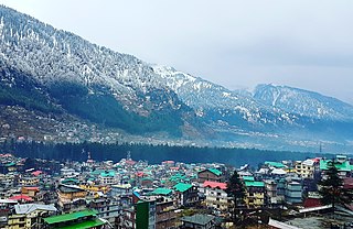
Manali is a resort town, near Kullu town in Kullu district in the Indian state of Himachal Pradesh. It is situated in the northern end of the Kullu Valley, formed by the Beas River. The town is located in the Kullu district, approximately 270 kilometres (170 mi) north of the state capital of Shimla and 544 kilometres (338 mi) northeast of the national capital of New Delhi. With a population of 8,096 people recorded in the 2011 Indian census Manali is the beginning of an ancient trade route through Lahaul (H.P.) and Ladakh, over the Karakoram Pass and onto Yarkand and Hotan in the Tarim Basin of China. Manali is a popular tourist destination in India and serves as the gateway to the Lahaul and Spiti district as well as the city of Leh in Ladakh.

Kishtwar National Park is a national park located, just 40 km from Kishtwar town in the Kishtwar district of Jammu and Kashmir, India. It is bounded to the north by Rinnay river, south by Kibar Nala catchment, east by main divide of Great Himalaya and west by Marwah river.

Shimla district, known as Simla district until 1972, is one of the twelve districts of the state of Himachal Pradesh in northern India. Its headquarters is the state capital of Shimla. Neighbouring districts are Mandi and Kullu in the north, Kinnaur in the east, Uttarakhand in the southeast, Solan to the southwest and Sirmaur in the south. The elevation of the district ranges from 987 metres (3,238 ft) to 4,500 metres (14,764 ft).

Chaupal is a town and nagar panchayat in the Shimla district of the Indian state of Himachal Pradesh.

Jubbal is a tehsil, town and a nagar panchayat in Shimla district in the Indian state of Himachal Pradesh which shares its boundary with the state of Uttrakhand towards south-east. Jubbal is recognised as a major apple producing area in Shimla district along with Kotgarh, Kumarsain, Kotkhai and Chopal. It is famous for its Hindu temples, picturesque mountains and its royal palace situated in the town.
Kotkhai is a town and a Nagar Panchayat in Shimla district in the Indian state of Himachal Pradesh.The name Kotkhai is derived from Hindi and Urdu language where the name "Kot" means Kings Palace and "Khai" means depth, therefore "Kotkhai" means "Kings palace situated in depth". It is a tehsil with around 40 villages under its administration. The whole tehsil is known for quality apple production. Kotkhai is also known for its fairs and traditional values, people of Kotkhai are really devotional towards Devtas where each villages believes in different forms of Devtas.

Parwanoo or Parwanu is a municipal council in Solan district in the Indian state of Himachal Pradesh. It is an industrial town. It has Himachal's biggest wholesale market. First in 3rd-category of Swachh Vayu Sarvekshan award 2023. It borders Panchkula district of Haryana, and is after the towns of Pinjore and Kalka on the Chandigarh Simla Highway. In fact it is separated by a river bed from the town of Kalka. Pinjore to Parwanoo is almost a continuous urban belt. From Pinjore there is also a road to Baddi, another nearby industrial town of Himachal.

Theog is a town and a municipal committee as well as a tehsil in Shimla district in the Indian state of Himachal Pradesh. It is 30 km from state capital Shimla and 37 km from ISBT Shimla. First settlements were in 1902.

Banjar is a town in Kullu district in the state of Himachal Pradesh, India. Banjar is one of the five sub-divisions of Kullu district. Banjar town serves as the headquarters of Banjar sub-division and tehsil. Culturally, it is a part of the Seraj region that extends from Jalori pass to Shikari Devi in Janjehli. A dialect of Kullavi called Seraji is spoken in the region and the natives are also called Serajis. The tourist attractions of Tirthan valley and Jibhi are a part of the Banjar region with Banjar town being the main marketplace in Tirthan Valley.

Sarahan is a small town in Himachal Pradesh of India. It is the site of the Bhimakali Temple, originally known as Bhimadevi Temple, dedicated to the mother goddess Bhimakali, presiding deity of the rulers of the former Bushahr State. The temple is situated about 170 kilometres from Shimla and is one of 51 Shakti Peethas. The town is known as the "gateway of Kinnaur" it being near the old Indo-Tibetan Road. Seven kilometers below Sarahan is the river Satluj. Sarahan is identified with the Shonitpur mentioned in Puranas. Sarahan Bushahr has been the summer capital of Bushahr kingdom, with Rampur Bushahr considered the winter capital. The former Chief Minister of Himachal Pradesh Shree Virbhadra Singh is a member of royal family and is popularly known as "Raja Sahab" at Sarahann. He has been member of the Assembly/Parliament since 1962 and has held the post of Chief Minister six times. His wife Rani Pratibha Devi is also a member of Assembly.

The Western Himalayan broadleaf forests is a temperate broadleaf and mixed forest ecoregion which is found in the middle elevations of the western Himalayas, including parts of Nepal, India, and Pakistan.

The Western Himalayan subalpine conifer forests is a temperate coniferous forests ecoregion of the middle and upper elevations of the western Middle Himalayas of Nepal, India, and Pakistan.

Baragaon is a village in Kumarsain subdivision of Shimla district in the Indian state of Himachal Pradesh.

National Highway 5 (NH5) is a primary national highway in India, running from West to East, connecting Firozpur in Punjab to the Sino-Indian border at Shipki La. The highway passes through Moga, Jagraon, Ludhiana, Mohali, Chandigarh, Panchkula, Kalka, Solan, Shimla, Theog, Narkanda, Kumarsain, Rampur Bushahr and continues along the Sutlej River till its terminus near the Tibet border.

Hatu Peak is located in the Shimla district of Himachal Pradesh in India. It is one of the highest peaks in the region, standing at an elevation of 3400 meters (11,152ft) above sea level. The peak is surrounded by a dense forest of conifers, oaks, and maples.

Kumarsain, also known as Kumharsain, is a town in Shimla District in the Indian state of Himachal Pradesh. Formerly under the British Raj, it was the capital of princely state of Kumharsain, which was one of the several states of the Punjab States Agency. It is about 80 km from Shimla and famous for apple and cherry orchards.

Tourism in Himachal Pradesh relates to tourism in the Indian state of Himachal Pradesh. This is popularly renowned for its Himalayan landscapes and popular hill-stations. Many outdoor activities such as rock climbing, mountain biking, paragliding, ice-skating, trekking, rafting, and heli-skiing are popular tourist attractions in Himachal Pradesh.

Nankhari is a Tehsil (town) and a block in Shimla district in the Indian state of Himachal Pradesh. It is about 92.5 km from Shimla and 33 km from Narkanda and NH 5. It consists of 17 Gram panchayat and 102 villages.


