
The Brahmaputra is a trans-boundary river which flows through Southwestern China, Northeastern India, and Bangladesh. It is known as Brahmaputra or Luit in Assamese, Yarlung Tsangpo in Tibetan, the Siang/Dihang River in Arunachali, and Jamuna River in Bengali. By itself, it is the 9th largest river in the world by discharge, and the 15th longest.

Tezpur is a city in Sonitpur district, Assam state, India. Tezpur is located on the banks of the river Brahmaputra, 175 kilometres (109 mi) northeast of Guwahati, and is the largest of the north bank cities.

Guwahati is the largest city of the Indian state of Assam, and also the largest metropolis in northeastern India. Dispur, the capital of Assam, is in the circuit city region located within Guwahati and is the seat of the Government of Assam. Its airport is the 12th busiest in India, the Lokpriya Gopinath Bordoloi International Airport. A major riverine port city along with hills, and one of the fastest growing cities in India, Guwahati is situated on the south bank of the Brahmaputra. The city is known as the "gateway to North East India".

Mājuli or Majuli is a large river island located in Assam, India. It is formed by the Brahmaputra River to the south and east, the Subansiri River to the west and an anabranch of the Brahmaputra River called Kherkutia Xuti to the North.

The Battle of Saraighat was a naval battle fought in 1671 between the Mughal Empire, and the Ahom Kingdom on the Brahmaputra river at Saraighat, now in Guwahati, Assam, India. This was the decisive battle that ended the years long Mughal siege of Guwahati, with the Ahoms pushing away the Mughals west beyond the Manas river.
Saraighat is a neighborhood in the Indian city of Guwahati, on the north bank of the river Brahmaputra. Sarai was a small village where the old abandoned N.F. Railway station of Amingaon was located.
Dhemaji is a small town and the headquarters of the Dhemaji district in the state of Assam, India. It is situated on the north bank of the Brahmaputra River and serves as an important administrative and commercial centre for the surrounding area.The town is known for its serene environment, traditional Assamese culture, and proximity to natural attractions like hills, rivers and forests.
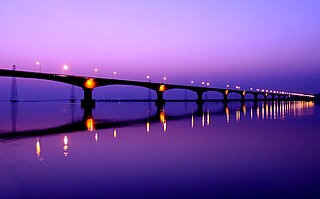
Kolia Bhomora Setu, an existing bridge completed in 1987, is a 3.015 km long pre-stressed concrete road bridge on NH-715 over the Brahmaputra River in Tezpur Assam state of India, which connects Tezpur in Sonitpur district on northern bank with Kaliabor in Nagaon District on the south bank. It is named after the Ahom General Kolia Bhomora Phukan. A new Bhomoraguri-Tezpur Bridge 3.040 km long, few meters parallel to the existing Kolia Bhomora Setu, is opened in 2021.
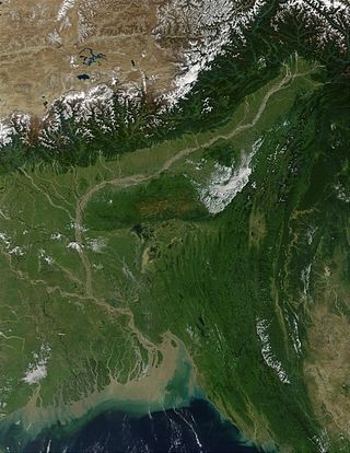
The Brahmaputra Valley is a region situated between hill ranges of the eastern and northeastern Himalayan range in Eastern India.
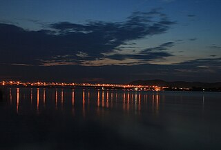
The Saraighat Bridge is a rail-cum-road bridge over Brahmaputra River in Assam, India and is the first of its kind bridge over the river in the state. The length of the bridge is 1492 meters and the road on the bridge is 7.3 meters wide.

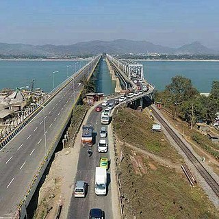
Naranarayan Setu (IPA - nərəˈna:ra:jənə ˈseɪtu:) is the third bridge to have been constructed over the Brahmaputra River in Assam, India. It is a double-deck bridge with a railway track on the lower deck and a road on the upper deck. It has a length of 2.284 kilometres and connects Jogighopa, a town of Bongaigaon District on the north with Pancharatna, a town of Goalpara District on the south. The bridge was inaugurated on 15 April 1998 by Atal Bihari Vajpayee, the Prime Minister of India at that time. Construction was carried out by the consortium of The Braithwaite Burn and Jessop Construction Company Limited(BBJ). The approximate cost of construction of this bridge is Rs. 301 crore. This bridge is located on route of National Highway 17, erstwhile route NH-37.

The New Bongaigaon–Guwahati section of the Barauni–Guwahati line connects New Bongaigaon and Guwahati in the Indian state of Assam.
The Barauni–Guwahati railway line connects Barauni, Saharsa, Purnia and Katihar in the Indian state of Bihar and Bongaigaon, Kamakhya and Guwahati in Assam via Siliguri, Jalpaiguri, Cooch Behar and Alipurduar in West Bengal. It is a linkage of prime importance for Northeastern India with Capital of india.

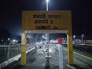
Rangiya Junction Railway Station is a junction station on the New Bongaigaon–Guwahati section of Barauni–Guwahati line, and Rangia–Tezpur line of Rangiya–Murkongselek section. It is located in Kamrup district in the Indian state of Assam. It serves Rangiya and the surrounding areas.. Rangiya Junction is the 4th largest railway station in Northeast India.

The Bogibeel Bridge is a combined road and rail bridge over the Brahmaputra River in the northeastern Indian state of Assam between Dhemaji district and Dibrugarh district, which was started in the year 2002 and took a total of 200 months(16 years and 8 months) to complete, Bogibeel river bridge is the longest rail-cum-road bridge in India, measuring 4.94 kilometres over the Brahmaputra river. As it is situated in an earthquake-prone area it is India's first bridge to have fully welded steel-concrete support beams that can withstand earthquakes of magnitudes up to 7 on the Richter scale. It is Asia's second longest rail-cum-road bridge and has a serviceable period of around 120 years.
The Rangiya–Murkongselek section is a 450 km (280 mi) long railway line connecting Rangiya in Kamrup district with Murkongselek in Dhemaji district in the Indian state of Assam. The entire section is under the jurisdiction of Northeast Frontier Railway.

The Dhola-Sadiya Bridge, officially known as Bhupen Hazarika Bridge, is a beam bridge in India, connecting the northeast states of Assam and Arunachal Pradesh. The bridge spans the Lohit River, a major tributary of the Brahmaputra, connecting the village of Dhola in the south to the village of Sadiya to the north, both in Tinsukia district of Assam, and providing convenient access to Arunachal Pradesh, whose border lies a short distance from Sadiya. The bridge is the first permanent road connection between the northern Assam and eastern Arunachal Pradesh.
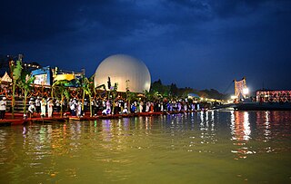
Namami Brahmaputra was an international festival that celebrates the beauty of the Brahmaputra river. It is organised by Assam Government. It was the first international river festival to be held in Assam. It was celebrated from 31 March-4 April 2017. The then President of India, Shri Pranab Mukherjee, inaugurated the ‘Namami Brahmaputra’ festival.

Saraighat War Memorial Park is a park at Agyathuri in North Guwahati, on the northern bank of river Brahmaputra, India. The park was constructed by Guwahati Metropolitan Development Authority, Assam. This park is constructed for preservation and promotion of the memories associated with the Battle of Saraighat.

