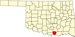
New Woodville, Oklahoma

Last updated

New Woodville, Oklahoma
OKMap-doton-Woodville.PNG
Location of New Woodville, Oklahoma
Coordinates: 33°58′7″N96°39′15″W / 33.96861°N 96.65417°W / 33.96861; -96.65417
Country United States
State Oklahoma
County Marshall
Area
[1]
  Total0.11 sq mi (0.28 km2)
  Land0.11 sq mi (0.28 km2)
  Water0.00 sq mi (0.00 km2)
Elevation
748 ft (228 m)
Population
 (2020)
  Total60
  Density560.75/sq mi (217.08/km2)
Time zone UTC-6 (Central (CST))
  Summer (DST) UTC-5 (CDT)
FIPS code 40-82100 [2]
GNIS feature ID1100004 [3]

New Woodville is a town in Marshall County, Oklahoma, United States. The population was 60 as of the 2020 Census. [4] Listed erroneously by the Census Bureau as "Woodville" from 1980 to 2000, the town's name was corrected in Census Bureau listings in 2005. [5] Proposals to annex the unincorporated areas of New Woodville and McBride on the shores of Lake Texoma were considered in the past.

Contents

History

The original town of Woodville was established as Harney, with its post office opening November 8, 1881. [6] It was renamed Woodville on July 9, 1888 in honor of local settler L.L. Wood. [6] Construction of a St. Louis and San Francisco Railway affiliate through the area in 1900 stimulated growth, with the town having 3 newspapers, a grain elevator, and cotton gins, resulting in a community with a school and nine brick buildings. [6] It was incorporated as a town between 1900 and 1907. [6] That original Woodville, having approximately 300 residents, was dissolved around 1943 or 1944 when the area was flooded due to the Red River being dammed by Denison Dam to create Lake Texoma. [7] [8] The town of New Woodville was incorporated, with around 50 of the former Woodville residents moving to the new location about two miles north of the original townsite. [7] [8] New Woodville disincorporated for brief periods in the late 90s or the early 2000s, but has legally existed since 2002 although the town government has been inactive. [6]

The drought of 2013 reduced the level of Lake Texoma sufficiently to expose some of old Woodville's foundations and storm cellars. [9]

Geography

New Woodville is located at 33°58′7″N96°39′15″W / 33.96861°N 96.65417°W / 33.96861; -96.65417 (33.968724, -96.654078). [10]

According to the United States Census Bureau, the town has a total area of 0.1 square miles (0.26 km2), all land.

The town is southeast of Kingston, Oklahoma, just off Oklahoma State Highway 70A. [11]

Armstrong Road, Durham Street, and Lee Ann Drive are north of the BNSF tracks which do not have a bypass because they do not connect to any other streets.

Demographics

Historical population
CensusPop.Note
1910 389
1920 44313.9%
1930 353−20.3%
1940 3643.1%
1950 78−78.6%
1960 9825.6%
1970 11820.4%
1980 94−20.3%
1990 31−67.0%
2000 69122.6%
2010 13291.3%
2020 60−54.5%
U.S. Decennial Census [12]

As of the census [2] of 2000, there were 69 people, 27 households, and 18 families residing in the town. The population density was 605.8 inhabitants per square mile (233.9/km2). There were 37 housing units at an average density of 324.9 per square mile (125.4/km2). The racial makeup of the town was 98.55% White and 1.45% Native American. Hispanic or Latino of any race were 2.90% of the population.

There were 27 households, out of which 37.0% had children under the age of 18 living with them, 44.4% were married couples living together, 18.5% had a female householder with no husband present, and 33.3% were non-families. 33.3% of all households were made up of individuals, and 11.1% had someone living alone who was 65 years of age or older. The average household size was 2.56 and the average family size was 3.00.

In the town, the population was spread out, with 34.8% under the age of 18, 2.9% from 18 to 24, 33.3% from 25 to 44, 21.7% from 45 to 64, and 7.2% who were 65 years of age or older. The median age was 31 years. For every 100 females, there were 86.5 males. For every 100 females age 18 and over, there were 125.0 males.

The median income for a household in the town was $9,375, and the median income for a family was $9,375. Males had a median income of $15,625 versus $18,750 for females. The per capita income for the town was $5,438. There were 52.9% of families and 47.5% of the population living below the poverty line, including 36.8% are under age 18 and 57.1% of those over age 64.

Related Research Articles

<span class="mw-page-title-main">Fannin County, Texas</span> County in Texas, United States

Fannin County is a county in the far northeast of the U.S. state of Texas, on the border with Oklahoma. As of the 2020 census, its population was 35,662. The county seat is Bonham.

<span class="mw-page-title-main">Payne County, Oklahoma</span> County in Oklahoma, United States

Payne County is a county located in the U.S. state of Oklahoma. As of the 2020 census, its population was 81,646. Its county seat is Stillwater. The county was created in 1890 as part of Oklahoma Territory and is named for Capt. David L. Payne, a leader of the "Boomers".

<span class="mw-page-title-main">Marshall County, Oklahoma</span> County in Oklahoma, United States

Marshall County is a county located on the south central border of Oklahoma. As of the 2020 census, the population was 15,312. Its county seat is Madill. The county was created at statehood in 1907 from the former Pickens County of the Chickasaw Nation. It was named to honor the maiden name of the mother of George Henshaw, a member of the 1906 Oklahoma Constitutional Convention. The county and its cities are part of the Texoma region.

<span class="mw-page-title-main">Love County, Oklahoma</span> County in Oklahoma, United States

Love County is a county on the southern border of the U.S. state of Oklahoma. As of the 2020 census, the population was 10,146. Its county seat is Marietta. The county was created at statehood in 1907 and named for Overton Love, a prominent Chickasaw farmer, entrepreneur and politician.

<span class="mw-page-title-main">Johnston County, Oklahoma</span> County in Oklahoma, United States

Johnston County is a county located in the U.S. state of Oklahoma. As of the 2020 census, the population was 10,272. Its county seat is Tishomingo. It was established at statehood on November 16, 1907, and named for Douglas H. Johnston, a governor of the Chickasaw Nation.

<span class="mw-page-title-main">Creek County, Oklahoma</span> County in Oklahoma, United States

Creek County is a county located in the U.S. state of Oklahoma. As of the 2020 census, the population was 71,754. Its county seat is Sapulpa.

<span class="mw-page-title-main">Bryan County, Oklahoma</span> County in Oklahoma, United States

Bryan County is a county in the U.S. state of Oklahoma. As of the 2020 census, the population was 46,067. Its county seat is Durant. It is the only county in the United States named for Democratic politician William Jennings Bryan.

<span class="mw-page-title-main">Italy, New York</span> Town in New York, United States

Italy is a town located in Yates County, New York, United States. As of the 2010 census, the town had a total population of 1,141. The town takes its name from the country of Italy.

<span class="mw-page-title-main">Lewiston Woodville, North Carolina</span> Town in North Carolina, United States

Lewiston Woodville is a town in Bertie County, North Carolina, United States. The population was 549 at the 2010 census. It is the location of Perdue Farms, one of the largest chicken-producing companies in North Carolina.

<span class="mw-page-title-main">Okeene, Oklahoma</span> Town in Oklahoma, United States

Okeene is a town in Blaine County, Oklahoma, United States. The population was 1,090 as of the 2020 United States census. The name was created by combining the last letters of Cherokee and Cheyenne.

<span class="mw-page-title-main">Armstrong, Oklahoma</span> Town in Oklahoma, United States

Armstrong is a town in Bryan County, Oklahoma, United States, along the Blue River. The population was 105 at the 2010 census, a 25.2 percent decrease from the figure of 141 recorded in 2000. The town was named for Frank C. Armstrong, a member of the Dawes Commission.

<span class="mw-page-title-main">Kenefic, Oklahoma</span> Town in Oklahoma, United States

Kenefic is a town in Bryan County, Oklahoma, United States. The population was 196 at the 2010 census, a 2 percent increase from the total of 192 recorded in 2000. The town was named for William Kenefick, president of the Missouri, Oklahoma and Gulf Railroad (MO&G), which had constructed a rail line through the region. The town name has been spelled both Kenefic and Kenefick throughout its history.

<span class="mw-page-title-main">Boswell, Oklahoma</span> Town in Oklahoma, United States

Boswell is a town in Choctaw County, Oklahoma, United States. The population was 709 at the 2010 census.

<span class="mw-page-title-main">Taloga, Oklahoma</span> Town in Oklahoma, United States

Taloga is a town in Dewey County, Oklahoma, United States. The population was 288 at the time of the 2020 census.

<span class="mw-page-title-main">Milburn, Oklahoma</span> Town in Oklahoma, United States

Milburn is a town in Johnston County, Oklahoma, United States, along the Blue River. The population was 252 as of the 2020 Census. The town is notable as the location of the Chickasaw White House, the former home of Chickasaw Governor Douglas H. Johnston. This home is now a museum and is listed on the NRHP.

<span class="mw-page-title-main">Madill, Oklahoma</span> City in Oklahoma, United States

Madill is a city in and the county seat of Marshall County, Oklahoma, United States. It was named in honor of George Alexander Madill, an attorney for the St. Louis-San Francisco Railway. The population was 3,914 as of the 2020 Census, up 3.8% from the figure reported in the 2010 census of 3,770, which itself was an increase of 10.8 percent from the 3,410 reported at the 2000 census. It is best known as the site of the annual National Sand Bass Festival. It is part of the Texoma region.

<span class="mw-page-title-main">Mazie, Oklahoma</span> CDP in Oklahoma, United States

Mazie is a census-designated place (CDP) in Mayes County, Oklahoma, United States. The population was 91 at the 2010 census.

<span class="mw-page-title-main">Cleveland, Oklahoma</span> City in Oklahoma, United States

Cleveland is a city in Pawnee County, Oklahoma, United States. The population was 3,205 as of the 2020 Census.

<span class="mw-page-title-main">Westport, Oklahoma</span> Town in Oklahoma, United States

Westport is a town in Pawnee County, Oklahoma, United States. The population was 448 as of the 2020 Census, a 50.3% increase over the figure of 298 at the 2010 census, which was itself a gain of 12.9% over the figure of 264 reported in 2000.

<span class="mw-page-title-main">Lake Bosworth, Washington</span> CDP in Washington, United States

Lake Bosworth is a census-designated place (CDP) in Snohomish County, Washington, United States. The population was 868 at the 2020 census, up from 667 at the 2010 census.

References

  1. "ArcGIS REST Services Directory". United States Census Bureau. Retrieved September 20, 2022.
  2. 1 2 "U.S. Census website". United States Census Bureau . Retrieved January 31, 2008.
  3. "US Board on Geographic Names". United States Geological Survey. October 25, 2007. Retrieved January 31, 2008.
  4. "New Woodville (town), Oklahoma". U.S. Census Bureau. Retrieved July 14, 2024.
  5. Population Estimates Boundary Changes Archived 2006-02-06 at the Wayback Machine , United States Census Bureau, 2007-07-01. Accessed 2008-11-06.
  6. 1 2 3 4 5 "Woodville". Oklahoma Historical Society. Retrieved July 14, 2024.
  7. 1 2 Michael Graczyk and Angela K. Brown (November 20, 2011). "Depleted Texas lakes expose ghost towns, graves". Kansas City Star. Retrieved November 20, 2011.
  8. 1 2 "Woodville, Oklahoma, et al. v. United States, 152 F.2nd 735 (Tenth Circuit, 1946)". v/lex. Retrieved July 14, 2024.
  9. KTEN. Hair, Kris. "Secrets of the Lake: Old Woodville." November 2, 2011. Retrieved September 10, 2013.
  10. "US Gazetteer files: 2010, 2000, and 1990". United States Census Bureau. February 12, 2011. Retrieved April 23, 2011.
  11. "New Woodville, Oklahoma". Google Maps. Retrieved July 14, 2024.
  12. "Census of Population and Housing". Census.gov. Retrieved June 4, 2015.