Newton Boyd, New South Wales

Last updated

Newton Boyd
New South Wales
Australia New South Wales location map blank.svg
Red pog.svg
Newton Boyd
Coordinates 29°45′14.0″S152°15′11.3″E / 29.753889°S 152.253139°E / -29.753889; 152.253139 Coordinates: 29°45′14.0″S152°15′11.3″E / 29.753889°S 152.253139°E / -29.753889; 152.253139
Population21 (2021 census) [1]
Postcode(s) 2370
Elevation353 m (1,158 ft)
Location
LGA(s) Clarence Valley, Glen Innes Severn
County Gresham
Parish Newton Boyd, Henry
State electorate(s) Clarence, Glen Innes
Federal division(s) Page, New England

Newton Boyd is a rural locality in the Northern Rivers region of New South Wales, Australia. There once was a village of the same name. At the 2021 census, the population was 21. [2]

Contents

Location

The area now known as Newton Boyd lies within the traditional lands of the Baanbay, [3] a group of the Gumbainggir. [4] [5]

The rural locality of Newton Boyd consists of the valleys of the Henry River and its tributary Bruisers Creek, much of the upper part valley of the Mann River, a part of the valley of the Boyd River, and mountainous land adjoining those valleys. [6]

The Henry River and, below its confluence with the that river, the Mann River, form the boundary between the Clarence Valley and Glenn Innes Severn local government areas, [7] and consequently, the Newton Boyd locality is divided between those two local government areas.

Name and early years of colonial settlement

The area was said to be called Begann, in the local language. [8]

The first use of the name Newton Boyd was as the name of a squatter run taken up by Alexander Boyd, by dispossessing the local people of their land. The name was in use by 1845, [9] and Boyd occupied the land, until 1849, [10] giving the area its colonial settler name.

Despite being occupied by colonial settlers, there were still around 200 local Aboriginal people living in the area, in the 1870s, [11] and some acts of violence between the two communities. [12] An Aboriginal man, Billy Buchan, who had worked as a stockman at Newton Boyd, and died in 1915, recalled two massacres of Aborigines, by vengeful colonial settlers, in northern New South Wales. [13]

Village

The village of Newton Boyd, officially a town, was located on both sides of a road crossing of the Henry River upstream of its confluence with the Mann River. [14] A site of 1,440 acres was reserved for a village in 1866, 70 chains east of the woolshed of the Newton Boyd run. [15]

In the time before the railway was built to Glen Innes, the old road from Grafton, via Dalmorton and Newton Boyd, completed around 1869, was the main route for transport to and from the Northern Tablelands. [16] [17] A hotel was nearing completion at the crossing of the Henry River by September 1871. [11] In August 1871, a site was reserved for the town of Newton Boyd. [18] By late 1874, the hotel and a blacksmith's shop were the only buildings in the town, with the same person serving as both innkeeper and blacksmith. [19] In 1875, a contract was awarded for a bridge across the Henry River at Newton Boyd. [20]

Local Aboriginal people supplying the hotel with fish that they caught in the river, in exchange for alcohol. A local free selector supplied the hotel with other produce. [19]

In October 1918, the settlement hosted a visit by General Pau and others of a visiting French mission. [21]

During the early 1920s, some larger holdings in the area were sub-divided and converted to dairy farming, and a cheese factory opened at Newton Boyd. A sawmill opened around the same time, [22] [23] and timber getting in the nearby forests was also an occupation for residents of Newton Boyd. [24] There was also some gold mining in the area, [25] [26] and, in 1918, there was a molybdenite mine about two miles from the village. [27] Despite these sources of employment, Newton Boyd never grew into a large settlement.

The hotel, by then known as the Rosemount Hotel, was badly damaged by fire in January 1941, and its licence was surrendered in late 1941. By then, the population, within a five mile radius was said to be less than 25. [28] Newton Boyd had a school from January 1896 to December 1974. [29] The village had a post office. [30] There was also a war memorial hall, opened, in September 1924, by Governor de Chair, who also unveiled the village's war memorial. [31]

In 1924 and 1959, the area of the town was reduced by the closure of some streets. [32] [33] In 1968, Newton Boyd was mentioned only as a hamlet. [34]

Present day

There is little left of the village now, other than its war memorial. [35] The roll of honour from the Newton Boyd hall is now at a museum in Glen Innes. [36] The portion of the main road through the village site is still known as Clarence Street, and it provides the link between Old Grafton Road (from the Glenn Innes end) and Old Glen Innes Road (from the Grafton end). [37]

The land in the valley bottoms within the locality is mostly cleared for agriculture, and mainly used for grazing. Much of the higher, forested areas are either part of Nymboyda National Park or Gibraltar Range National Park. [6]

Related Research Articles

<span class="mw-page-title-main">Grafton, New South Wales</span> City in New South Wales, Australia

Grafton is a city in the Northern Rivers region of the Australian state of New South Wales. It is located on the Clarence River, approximately 608 kilometres (378 mi) by road north-northeast of the state capital Sydney. The closest major cities, Brisbane and the Gold Coast, are located across the border in South-East Queensland. At the 2021 census, Grafton had a population of 19,255. The city is the largest settlement and, with Maclean, the shared administrative centre of the Clarence Valley Council local government area, which is home to over 50,000 people in all.

<span class="mw-page-title-main">Gwydir Highway</span>

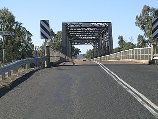
Gwydir Highway is a 568-kilometre (353 mi) state highway in northern New South Wales, Australia. The highway was named after the Gwydir River, which in turn was named after a locale in Wales.

<span class="mw-page-title-main">Glen Innes, New South Wales</span> Town in New South Wales, Australia

Glen Innes is a parish and town on the Northern Tablelands, in the New England region of New South Wales, Australia. It is the centre of the Glen Innes Severn Shire Council. The town is located at the intersection of the New England Highway and the Gwydir Highway. At the 2016 census, Glen Innes had a population of 6,155.

<span class="mw-page-title-main">Clarence Valley Council</span> Local government area in New South Wales, Australia

Clarence Valley Council is a local government area in the Northern Rivers region of New South Wales, Australia.

<span class="mw-page-title-main">Summerland Way</span>

Summerland Way is a 199–kilometre state route, designated B91, in New South Wales. It runs generally north from Grafton to the state border with Queensland just west of Mount Lindesay, and continues from there into Queensland as Mount Lindesay Highway. It was named as the region in runs through is a popular tourist area for people during summer.

<span class="mw-page-title-main">Capertee, New South Wales</span> Town in New South Wales, Australia

Capertee pronounced is a village 46 km north of Lithgow, New South Wales, Australia. It is on an elevated site above the Capertee Valley. In 2016, the township had a population of 145 people. The Castlereagh Highway links Capertee with Lithgow to the south and Mudgee to the north. The township is surrounded by National Parks and grazing land. Principal employment is in coal mining, farming and tourism-related services. The Capertee Valley forms a part of the catchment area of the Hawkesbury River, but the village lies very close to the Great Divide watershed, with the Turon River catchment nearby to its west.

<span class="mw-page-title-main">Conargo</span> Town in New South Wales, Australia

Conargo is a town in the Riverina region of New South Wales, Australia. The town is in the Edward River Council local government area. It is on Billabong Creek, a tributary of the Edward River. The nearest towns are Jerilderie and Deniliquin. At the 2006 census, Conargo had a population of 188 people.

<span class="mw-page-title-main">Clarence River (New South Wales)</span> River in New South Wales, Australia

The Clarence River is a river situated in the Northern Rivers district of New South Wales, Australia.

<span class="mw-page-title-main">Seaham, New South Wales</span> Suburb of Port Stephens Council, New South Wales, Australia

Seaham is a suburb of the Port Stephens local government area in the Hunter Region of New South Wales, Australia. It is located on the Williams River which flows into the Hunter River 14.6 km (9.1 mi) downstream from Seaham village at Raymond Terrace.

<span class="mw-page-title-main">Moulamein</span> Town in New South Wales, Australia

Moulamein is a small town in New South Wales, Australia, in the Murray River Council local government area. At the 2016 census, Moulamein had a population of 484. Moulamein is the oldest town in the Riverina.

<span class="mw-page-title-main">Nambucca Heads</span> Town in New South Wales, Australia

Nambucca Heads is a town on the Mid North Coast of New South Wales, Australia in the Nambucca Valley. It is located on a ridge, north of the estuary of the Nambucca River near the Pacific Highway. Its 2021 population was 6,675, including 5,226 (78.3%) Australian-born persons and 672 indigenous persons.

<span class="mw-page-title-main">Wee Jasper, New South Wales</span> Town in New South Wales, Australia

Wee Jasper is a hamlet in the Goodradigbee valley at the western foot of the Brindabella Ranges, near Burrinjuck Dam in New South Wales, Australia in Yass Valley Shire. It is located about 90 km north-west of Canberra and 60 km south-west of Yass. At the 2021 census, Wee Jasper and the surrounding area had a population of 127.

<span class="mw-page-title-main">Electoral district of Bourke</span> State electoral district of New South Wales, Australia

Bourke was an electoral district of the Legislative Assembly in the Australian state of New South Wales from 1880 to 1904, including the towns of Bourke and Cobar. It elected two members simultaneously between 1882 and 1889 increasing to three members until 1894, with each elector being able to vote for as many candidates as there were vacancies.

<span class="mw-page-title-main">Harrow, Victoria</span> Town in Victoria, Australia

Harrow is a town in the Wimmera region of western Victoria, Australia. The town is located in the Shire of West Wimmera local government area, 391 kilometres north west of the state capital Melbourne, overlooking the Glenelg River valley. At the 2016 census, Harrow and the surrounding area had a population of 200.

<span class="mw-page-title-main">Wellingrove, New South Wales</span> Town in New South Wales, Australia

Wellingrove is a village located on the Wellingrove Road about 20 kilometres (12 mi) north west of Glen Innes, New South Wales on the Northern Tablelands, New South Wales, Australia. At the 2006 census, Wellingrove had a population of 113.

The Gibraltar Range is a mountain range in the Northern Tablelands region of New South Wales, Australia. The range extends off the Great Dividing Range at Bald Nob about 25 kilometres (16 mi) east northeast of Glen Innes and trends generally east northeast and north northeast for about 100 kilometres (62 mi) to the junction of Timbarra and Clarence rivers. It forms the watershed between these two rivers.

<i>Glen Innes Examiner</i>

The Glen Innes Examiner, previously published as the Glen Innes Examiner and General Advertiser, is an English language newspaper published bi-weekly in Glen Innes, New South Wales, Australia.

Augustus Ryan Fraser was a politician and pastoralist in New South Wales, Australia.

George James MacDonald was a Commissioner of Crown Lands in the British colony of New South Wales where he founded both the city of Armidale and the town of Balranald. He is mostly remembered for his role in leading a contingent of Border Police troopers in a large massacre of Indigenous Australians in the Clarence River region. MacDonald was also considered a talented linguist and writer, producing several published works of poetry and prose reflecting on his experiences in Australia.

Dalmorton is a locality in the Northern Rivers region of New South Wales, Australia. There once was a village of the same name, which was associated with gold mining. Much of the area of the locality is now reserved as National Parks or State Forests. At the 2016 census, the population of Dalmorton was four.

References

  1. Australian Bureau of Statistics (28 June 2022). "Newton Boyd (State Suburb)". 2021 Census QuickStats. Retrieved 9 February 2023. OOjs UI icon edit-ltr-progressive.svg
  2. "2021 Newton Boyd, Census All persons QuickStats | Australian Bureau of Statistics". abs.gov.au. Retrieved 9 February 2023.
  3. "Map showing the distribution of the Aboriginal tribes of Australia [cartographic material]". Trove. Retrieved 1 March 2021.
  4. Studies, Australian Institute of Aboriginal and Torres Strait Islander (10 November 2022). "Map of Indigenous Australia". aiatsis.gov.au. Retrieved 9 February 2023.
  5. "Aboriginal Australians near Newton Boyd, New South Wales, ca. 1848 [picture]". Trove. Retrieved 9 February 2023.
  6. 1 2 "Satellite View - Newton Boyd · New South Wales 2370, Australia". Google Maps. Retrieved 9 February 2023.
  7. "Glen Innes Severn Shire · New South Wales, Australia". Google Maps. Retrieved 9 February 2023.
  8. "Science of man and journal of the Royal Anthropological Society of Australasia, Vol. 12 No. 11 - Aboriginal Names and Meanings". Trove. 1 March 1911. p. 214. Retrieved 10 February 2023.
  9. "CLARENCE RIVER". Sydney Morning Herald . 9 April 1845. p. 3. Retrieved 9 February 2023.
  10. "TRANSFER OF RUNS". Moreton Bay Courier . 18 August 1849. p. 4. Retrieved 9 February 2023.
  11. 1 2 "The Tourist". Sydney Mail and New South Wales Advertiser . 23 September 1871. p. 935. Retrieved 9 February 2023.
  12. "The Newton Boyd Murder". Evening News . 2 November 1875. p. 5. Retrieved 9 February 2023.
  13. "DEATH OF BILLY BUCHAN". Richmond River Express and Casino Kyogle Advertiser . 27 August 1915. p. 7. Retrieved 9 February 2023.
  14. "Town of Newton Boyd and suburban lands [cartographic material] : Land Districts of Glen Innes & Grafton". Trove. Retrieved 9 February 2023.
  15. "RESERVES FROM CONDITIONAL PURCHASE". New South Wales Government Gazette . 3 August 1866. p. 1777. Retrieved 9 February 2023.
  16. "Early-Day Link With Newton Boyd". Glen Innes Examiner . 6 January 1945. p. 3. Retrieved 9 February 2023.
  17. "THE NEWTON BOYD ROAD". Armidale Express and New England General Advertiser . 17 October 1868. p. 2. Retrieved 9 February 2023.
  18. "SITE FOR TOWN OF NEWTON BOYD". New South Wales Government Gazette . 18 August 1871. p. 1822. Retrieved 9 February 2023.
  19. 1 2 "Notes of a Visit to Newton Boyd". Australian Town and Country Journal . 10 October 1874. pp. 13, 14. Retrieved 9 February 2023.
  20. "Government Gazette Tenders and Contracts". New South Wales Government Gazette . 20 July 1875. p. 2132. Retrieved 9 February 2023.
  21. "THE FRENCH MISSION IN QUEENSLAND AND N.S.W." Sydney Mail . 9 October 1918. p. 8. Retrieved 9 February 2023.
  22. "DAIRY FARMING". Farmer and Settler . 8 June 1923. p. 11. Retrieved 9 February 2023.
  23. "NEWTON BOYD". Glen Innes Examiner . 26 April 1923. p. 4. Retrieved 9 February 2023.
  24. "THE TIMBER-GETTER'S FAMILY". Sydney Mail. 9 April 1930. p. 16. Retrieved 10 February 2023.
  25. "GOLD AT NEWTON BOYD". Cessnock Eagle and South Maitland Recorder . 2 July 1926. p. 4. Retrieved 9 February 2023.
  26. "MINING AT NEWTON BOYD". Daily Examiner. 10 August 1916. p. 4. Retrieved 10 February 2023.
  27. "NEWTON BOYD". Daily Examiner . 6 June 1918. p. 4. Retrieved 9 February 2023.
  28. "HEARING ADJOURNED". Daily Examiner . 27 November 1941. p. 6. Retrieved 9 February 2023.
  29. "Newton Boyd". nswgovschoolhistory.cese.nsw.gov.au. Retrieved 9 February 2023.
  30. "RAIN GOES: GRAFTON ROAD OPENED LATE YESTERDAY". Glen Innes Examiner. 16 July 1954. p. 1. Retrieved 10 February 2023.
  31. "Governor at Newton Boyd". Glen Innes Examiner . 22 September 1924. p. 6. Retrieved 9 February 2023.
  32. "ALTERATION OF THE DESIGN OF THE TOWN OF NEWTON BOYD". Government Gazette of the State of New South Wales . 17 October 1924. p. 4828. Retrieved 9 February 2023.
  33. "ALTERATION OF DESIGN OF THE TOWN OF NEWTON BOYD". Government Gazette of the State of New South Wales . 28 August 1959. p. 2659. Retrieved 9 February 2023.
  34. "Walkabout, Vol. 34 No. 11, On the Move, The Gwydir Highway". Trove. 1 November 1968. p. 37. Retrieved 10 February 2023.
  35. "Newton Boyd War Memorial | Monument Australia". monumentaustralia.org.au. Retrieved 9 February 2023.
  36. "Newton Boyd Honour Roll | Monument Australia". monumentaustralia.org.au. Retrieved 9 February 2023.
  37. "Close satellite view - Newton Boyd · New South Wales 2370, Australia". Google Maps. Retrieved 9 February 2023.