
Winton is a rural town in Southland, New Zealand. It is located close to the east bank of the Oreti River, 30 kilometres north of Invercargill and 50 kilometres south of Lumsden. The town is named after Thomas Winton, a local stockman who lived and farmed in the area in the 1850s. Winton has a population of 2,211 as of the 2013 Census. The district thrived with the development of sheep and fat-lamb farms in the early 1900s. Later, dairy farming became the staple economy, although the town has also seen sawmills, and flax and linen-flax industries.
The Waikaka Branch was a branch line railway of the Main South Line that ran through agricultural and gold-mining country in Southland, New Zealand. It was constructed in 1907 and 1908, and was operated by the New Zealand Railways Department until its closure in 1962.

The Port Chalmers Branch was the first railway line built in Otago, New Zealand, and linked the region's major city of Dunedin with the port in Port Chalmers. The line is still operational today.
The Wyndham Branch, also known as the Glenham Branch, was a branch line railway in Southland, New Zealand. The first section was opened in 1882 and it operated until 1962. Although its name would imply that it terminated in Wyndham, an extension to a terminus in Glenham operated for forty years. It was operated by the New Zealand Railways Department.
The Mount Somers Branch, sometimes known as the Springburn Branch, was a branch line railway in the region of Canterbury, New Zealand. The line was built in stages from 1878, reaching Mount Somers in 1885. A further section to Springburn was added in 1889; this closed in 1957, followed by the rest of the line in 1968. A portion has been preserved as the Plains Vintage Railway.
The Kingston Branch was a major railway line in Southland, New Zealand. It formed part of New Zealand's national rail network for over a century: construction began in 1864, Kingston was reached in 1878, and it closed in 1979. For much of its life, it was considered a secondary main line rather than a branch line, and in its earlier years, it was sometimes known as the "Great Northern Railway". Today, the southern portion now forms a part of the Wairio Branch and the northernmost 14 kilometres was used by the Kingston Flyer.
The Hedgehope Branch, also known as the Browns Branch, was a branch line railway in Southland, New Zealand that started life in the 1880s as a privately owned bush tramway. It opened as a railway in 1899 and operated until 1968, though the section beyond Browns closed in 1953. It connected with the national rail network in Winton on the Kingston Branch.
The Tuatapere Branch, including the Orawia Branch, was a branch line railway in Southland, New Zealand. Although the Tuatapere and Orawia Branches look like a single line, operationally they were considered separate lines. The first section opened to Riverton in 1879 and reached Tuatapere three decades later. The extension from Tuatapere to Orawia operated from 1925 until 1970. In 1976 the Tuatapere Branch was truncated to Riverton, and was known as the Riverton Branch until 1978, when it closed beyond Thornbury. The remaining portion of the line is now part of the Wairio Branch.
The Ohai Line, formerly the Ohai Industrial Line and previously the Wairio Branch and the Ohai Railway Board's line, is a 54.5 km branch line railway in Southland, New Zealand. It opened in 1882 and is one of two remaining branch lines in Southland, and one of only a few in the country. A number of smaller privately owned railways fanned out from Wairio; one of these lines, to Ohai, was worked by New Zealand Railways from 1990 and incorporated into the national network in 1992.

Ngahere is a locality in the Grey District of the West Coast of New Zealand's South Island. The 2013 New Zealand census gave the population of Ngahere and its surrounding area as 363, an increase of 5.2% or 18 people since the 2006 census.
Ohai is a town in the Southland region of New Zealand's South Island, 65 kilometres northwest of Invercargill and 25 kilometres west of Winton. The 2013 New Zealand census gave its population as 303, a decline of 54 people since the 2006 census. https://www.southlandexpress.co.nz/property-news/affordable-housing-a-boon-for-ohai/
Edendale is a town in the Southland region of New Zealand's South Island. According to the 2013 New Zealand census, it had a population of 555, representing a rise of 42 people since the 2006 census. Before the town was called Edendale, it was known by the names Maorirua, Mataura Plains and Stuart's Bush.
Birchwood is a locality in the Southland region of New Zealand's South Island. It is situated west of Ohai and Nightcaps, and north of Tuatapere and Orawia, with the nearest state highway in Ohai.
Hector and Ngakawau are two lightly populated settlements located at the mouth of the Ngakawau River in the West Coast region of New Zealand. Both settlements are situated on State Highway 67 between Westport and Karamea. The 2001 New Zealand census found that Hector and Ngakawau have a combined population of 300, a drop of 16% or 57 people since the 1996 census. This has dropped further in 2006 to 234 people. Despite a low population, many of the workers at New Zealand's largest open-cut coal mine at Stockton choose to live at these places and shuttles frequently operate between the two places.
Thornbury is a small township on the east bank of the lower Aparima River, in western Southland, New Zealand. It is approximately 10 km northeast of Riverton, and 31 km northwest of Invercargill. It is mainly a farming service community. Local small industries include machinery and transport/trucking companies, and a tannery.
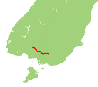
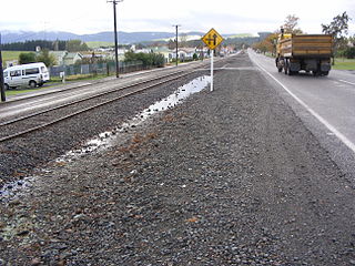
State Highway 96 is a New Zealand state highway connecting the Southland communities of Mataura, Winton, and Ohai. Starting at State Highway 1 the highway is 92 kilometres in length and runs in a general east-west direction. In Winton State Highway 96 runs concurrently with State Highway 6 for 1.6 kilometres.

State Highway 99 is a New Zealand state highway which runs along the southern coastline of the South Island connecting the settlements of Clifden and Lorneville, near Invercargill, via the major town of Riverton in the Southland region. The road is important both as a freight route, especially for logging and agricultural purposes, and as a tourist route; the entire length of the highway is part of the Southern Scenic Route as it provides access to southern parts of Fiordland National Park.

Branxholme locomotive dump is a steam locomotive and wagon dump located on the eastern bank of the Oreti River adjacent and just to the north of Southland's Wairio Branch Line in New Zealand. Locomotives and rolling stock have been dumped here for river protection since the 1920s. In the time since numerous items have been recovered for preservation purposes.
The Ohai Railway Board Heritage Trust is a defunct railway preservation society that was formed to preserve Southland's rail history. The trust was formerly based at Wairio on the Wairio Branch in the former Ohai Railway Board workshops, and owned a number of locomotives and items of rolling stock, including the remains of two P class 2-8-0 tender locomotives.
The Ohai Railway Board (ORB) was a short railway in Southland, New Zealand. The railway line itself still exists as the Ohai branch line, but the ORB was dissolved in 1990. The Ohai line is one of the few remaining rural branch lines out of many that once existed throughout New Zealand.
