Amador County is a county located in the U.S. state of California, in the Sierra Nevada. As of the 2020 census, the population was 40,474. The county seat is Jackson. Amador County, located within California's Gold Country, is known as "The Heart of the Mother Lode". There is a substantial viticultural industry in the county.

Calaveras County, officially the County of Calaveras, is a county in both the Gold Country and High Sierra regions of the U.S. state of California. As of the 2020 census, the population was 45,292. The county seat is San Andreas. Angels Camp is the county's only incorporated city. Calaveras is Spanish for "skulls"; the county was reportedly named for the remains of Native Americans discovered by the Spanish explorer Captain Gabriel Moraga.
Murphys, originally Murphys New Diggings then Murphy's Camp, is an unincorporated village located in the foothills of the Sierra Nevada mountains in Calaveras County, California, United States. The population was 2,213 at the 2010 census, up from 2,061 at the 2000 census.

The Gold Country is a historic region in the northern portion of the U.S. state of California, that is primarily on the western slope of the Sierra Nevada. It is famed for the mineral deposits and gold mines that attracted waves of immigrants, known as the 49ers, during the 1849 California Gold Rush.

State Route 49 is a north–south state highway in the U.S. state of California that passes through many historic mining communities of the 1849 California gold rush and it is known as the Golden Chain Highway. The highway's creation was lobbied by the Mother Lode Highway Association, a group of locals and historians seeking a single highway to connect many relevant locations along the Gold Rush to honor the 49ers. One of the bridges along SR 49 is named for the leader of the association, Archie Stevenot.

Dog Town is a gold rush era ghost town in Mono County, California. It is located at 38°10′13″N119°11′51″W, on Dog Creek, near the junction of Clearwater and Virginia Creeks, about 6 miles (10 km) south-southeast of Bridgeport, at an elevation of 7057 feet.
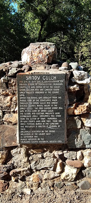
Chili Gulch is a gulch in Calaveras County, California. This five-mile gulch was the richest placer mining section in Calaveras County. It received its name from Chileans who worked it in 1848 and 1849, and was the scene of the so-called Chilean War. The largest known quartz crystals were recovered from a mine on the south side of the gulch.
Glencoe is an unincorporated community in Calaveras County, California. It lies at an elevation of 2,749 feet and is located at 38°21′15″N120°35′06″W. The community's ZIP code is 95232.
Altaville is a former unincorporated community in Calaveras County, California, now located in the northwest portion of the city of Angels Camp. It sits at an elevation of 1,542 feet above sea level and is located at 38°05′02″N120°33′43″W, at the intersections of SR 49 and SR 4. The community is in ZIP code 95221 and area code 209.

California Cavern is a Limestone cave in the Sierra Nevada foothills, in Cave City, Calaveras County, California.

Marshall Gold Discovery State Historic Park is a state park of California, United States, marking the discovery of gold by James W. Marshall at Sutter's Mill in 1848, sparking the California Gold Rush. The park grounds include much of the historic town of Coloma, California, which is now considered a ghost town as well as a National Historic Landmark District. The park contains thre California Historical Landmarks: a monument to commemorate James Marshall (#143), the actual spot where he first discovered gold in 1848 (#530). Established in 1942, and Coloma Road (#748),. The park now comprises 576 acres (233 ha) in El Dorado County.

Twisted Oak Winery is a family-owned boutique winery in Vallecito, California specializing in wine made from grape varieties native to the Mediterranean regions of western Europe. The winery is located on a hilltop at 2280 ft above sea level in the foothills of the Sierra Nevada Mountains, and most of the grapes for the wines are sourced from nearby vineyards in Calaveras County. The winery name and logo design are derived from a California Blue Oak tree on the property.
Middle Bar is a former mining town on the Mokelumne River in Amador County, California. It is a California Historical Landmark.
The Byrne's Ferry bridge was a historic cantilevered covered bridge across the Stanislaus River between Calaveras County and Tuolumne County, California. Originally built during the California Gold Rush, the bridge was located on the O'Byrne's Ferry road between Chinese Camp and Copperopolis. Until the mid-20th century, it was one of the last remaining covered bridges in the state; the bridge was destroyed in 1957 to make way for the construction of Tulloch Dam.

Dutton Hotel, Stagecoach Station is located on Jolon Road in Jolon, California. What remains are ruins of an adobe inn that was established in 1849. The Dutton Hotel was a major stagecoach stop on El Camino Real in the late 1880s. The landmark was listed on the National Register of Historic Places on October 14, 1971.
Prince-Garibaldi Building is a historical building in Altaville, California in Calaveras County. Altaville, California is just north of the town of Angels Camp. The building was built by B. R. Prince and G. Garibardi in 1852 as a general store on the first floor. The building is built built by David Strosberger out of rhyolite tuff stones designed. In 1857 a second floor was added and used for the store owner's living space. For a time the building was the Prince Undertaking Parlor with a plumed horse hearse. The Prince-Garibaldi Building is a California Historical Landmark No. 735 of California State Route 49.

Murphy's Ranch, also called Murphy's Corral, is a historical site in Elk Grove, California in Sacramento County. The site of Murphy's Ranch is a California Historical Landmark No. 680 listed on May 11, 1959. At Murphy's Ranch on June 10, 1846, was the start of the Bear Flag Revolt and Bear Flag Rebellion.