This article needs additional citations for verification .(March 2013) |
Omassery | |
---|---|
Town | |
![]() Omassery | |
![]() | |
Coordinates: 11°18′0″N75°58′30″E / 11.30000°N 75.97500°E | |
Country | ![]() |
State | Kerala |
District | Kozhikode |
Lok Sabha constituency | Kozhikode |
Government | |
• Body | Omassery |
• Member of Parliament | M. K. Raghavan |
• M.L.A | M. K. Muneer |
• Panchayath President | [[BASHEER PURAYIL} ]] |
Area | |
• Total | 25.46 km2 (9.83 sq mi) |
Population (2011) | |
• Total | 25,420 |
• Density | 998/km2 (2,580/sq mi) |
Languages | |
• Official | Malayalam, English |
Time zone | UTC+5:30 (IST) |
PIN | 673582 |
Telephone code | 91495228 |
Vehicle registration | KL-57 |
Nearest city | Kozhikode, koduvally |
Sex ratio | 1000:1032 ♂/♀ |
Literacy rate | 88.05% |
Omassery is a town in Kozhikode district, Kerala, India and it is a junction between Thiruvambady, Thamarassery, Mukkam, Koduvally, Kodenchery and Kattangal. Omassery is located 29 kilometers southeast of Kozhikode in the eastern part of Kerala; better known as Malabar (Northern Kerala). Omassery is a fast developing place and is well connected to the other parts of the state. Besides that, it is known as the gateway to the hill ranges of Western Ghats in Malabar.
Omassery is located at 11°18′0″N75°58′30″E / 11.30000°N 75.97500°E . The total area of the Panchayat is 25.46 square kilometres (9.83 sq mi) [1]
As of 2001 census the total population of the panchayat is 25,420, [1] which constitute 12511 Males and 12909 females. The population density is 998 per km2 which is more than the state average. The sex ratio is 1000:1032. The people are highly literate. The literacy rate is 88.05 (Male: 93.62 and female 82.76).
Koduvally, Kunnamangalam, Thamarassery, Mukkam, Thiruvambady, Kodenchery, NIT(REC)
Koodathai, Venappara, Neeleswaram, Ambalakkandy, Vennakode, Malayamma, Velimanna, Kallurutty, Puthur, north puthur Nadammal Poyil and Manipuram.
Omassery Panchayath consists of 19 wards. In ward number order, with ward, member name and party indicated: [2]
Omassery is the crossing of State Highways Koyilandy - Edavanna and Kappad-Thusharagiri-Adivaram. The location is well connected by roads from various corners and is a main junction for surrounding various panchayaths and villages. Moreover, it gives more geographical importance to this place as this is an important gateway to the hill ranges of western Ghat of Malabar. Thiruvambady, Thamarassery, Koduvally, Mukkam and Kodencheri are near by places of Omassery.
There is one bus stand and bus services available to places such as Kozhikode, Mukkam, Koduvally, Thamarassery, Thiruvambady, Kodenchery, Anakkampoyil.
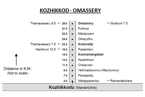
The Kilometer chart from Kozhikode to Omassery is given below.
The Kilometer chart through road from Omassery is given below.
Kozhikode - 29 km | Thamarassery - 9 km | Manjeri - 36 km | |
Mukkam - 7 km | Malappuram - 48 km | Ernakulam - 190 km | Guruvayur - 115 km |
Perinthalmanna - 60 km | Areekode - 20 km | Palakkad - 122 km | |
Thiruvambady - 6 km | Thrissur - 133 km | Anakkampoyil - 19 km | |
Koduvally - 6 km | Koyilandy - 37 km | Thiruvananthapuram - 414 km | |
Kodencheri - 10 km | Kalpetta - 58 km | Nilambur - 50 km |
Thiruvambady is a historic hill town in Kozhikode district in Kerala, India. Thiruvambady is a Panchayat headquarters, and a legislative assembly constituency, situated 35 kilometres (22 mi) from west of Kozhikode.
Mavoor is a town situated in Kozhikode district in Kerala, India. It is 19 km away from Kozhikode city.
Cheruvadi is a village in the Kozhikode district of Kerala. It is located 24 kilometres east of Kozhikode.
Chathamangalam is a village in Kozhikode district of Kerala state, India.
Kodanchery is a town in Kozhikode district in the state of Kerala, India.
Kodiyathur is a gram panchayat in Kozhikode district in the state of Kerala, India.
Puthuppadi is a village and Panchayath located in Kozhikode district of Kerala, India. Puthuppadi Grama Panchayat covers an area of 64.75 km2 and is spread over the villages of Engapuzha and Puthuppadi. The panchayat is bounded on the north by Thamarassery, Kattippara, Kodenchery, Vythiri (Wayanad) panchayats, on the east by Vythiri (Wayanad) and Kodancheri panchayats, on the south by Thamarassery and Kodancheri panchayats and on the west by Kattippara panchayat. Famous Wayandan Churam or Wayandan Pass, which has nine hairpins between Adivaram of Puthuppady Panchayath and Lakkidi of Vythri Panchayath, is in Puthuppadi Panchayat.
Thamarassery, formerly known as Thazhmalachery, is one of the taluks and a major hill town in the Kozhikode district of Kerala, India, 30 km north-east of Kozhikode (Calicut) city and 29 km east of Koyilandy. The town lies on National highway 766.
Koduvally is a major municipal town in Kozhikode district in the Indian state of Kerala. It is located on the National Highway 766 and is about 21 km northeast of Kozhikode (Calicut) city. Koduvally is known as the city of gold for its gold trade legacy since 18s and 19s. Koduvally is one of the 140 assembly constituencies in Kerala and One of the 12 block panchayats in kozhikode.The nearest local bodies are Kizhakkoth, Madavoor, kunnamangalam, Omassery, Mukkam, and Thamarassery. Koduvally also gives its name to the Koduvally River which flows west into the sea.
Kunnamangalam is a growing census town located about 14 km east of Kozhikode city on National highway 766. Nearby places are Koduvally, Mukkam, Chathamangalam, and Kattangal. India's premier educational institutions like Indian Institute of Management, Kozhikode (IIMK), National Institute of Technology Calicut, National Institute of Electronics & Information Technology, Indian Institute of Spices Research, and Kerala School of Mathematics, Kozhikode are located here. Kunnamangalam is developing as a suburb of Kozhikode, Kunnamangalam is the east side entry of Calicut city.
Mukkam is a major municipal town in Kozhikode, state of Kerala, India. Mukkam is located about 27 km east of Calicut city on the bank of river Iruvanjippuzha, one of the major tributaries of river Chaliyar.
Kattangal is a sub-urban town situated near the National Institute of Technology Calicut, located in Kerala, India. It is about 22 km distant from the city of Kozhikode. Chathamangalam Gramapanchayath is the village administration and this village is a major educational hub in Kerala. Mavoor–Koduvally Road and Kozhikode–Mukkam Highways are crossing at Kattangal town.one can see a miniature form of india and of course kerala when you just walk through kattangal. This is due to manual workers from bengal and north Indianstates and major educational institutions.
Nadammal Poyil is an interior village in Omassery Grama Panchayath in Kozhikode district. This village is midway between Omassery and Koduvally. The Nadammal Poyil town is situated on the shores of Puthoor Puzha which flows and joins to Chaliyar Puzha.
Chembukadavu is a village situated near to Thiruvambady and Kodanchery in Kozhikode district of Kerala. Thusharagiri Falls is near to here. The Chembukadavu Dam project I in Kozhikode, North Kerala, India is the first of the string of 14 small hydroelectric projects undertaken by the Kerala State Electricity Board (KSEB), in collaboration with Hang Tso International Centre in China.It is located about 50 km east of Kozhikode in the foothills of Western ghats
Kozhikode District has four types of administrative hierarchies:
C. Moyinkutty was an MLA, and the State Vice President of Indian Union Muslim League. He was previously elected to Kerala Legislative Assembly in 1996, 2006 and 2011 from Koduvally (1996-2001) and Thiruvambady constituencies. He was the Muthavalli and the President of Andona Mahal Juma Masjid.
Kozhikode district has an extensive network of road, rail and air travel services. Kozhikode city is the epicenter of the district. Vatakara, Koyilandy and Thamarassery are other transport hubs.
Aikkarappadi is a town in the Malappuram district in Kerala, India. Agriculture and education are its main industries.
Thottumukkam is a boarder village in the districts of Kozhikode and Malappuram Kerala, India, under the administration of Kodiyathur Grama Panchayath on the banks of Thottumukkampuzha, a major tributary of Chaliyar. It is bordered by Karassery of Kozhikode district and Urangattiri and Kizhuparamba Grama Panchayats of Malappuram district. Most of the people in the village are migrated farmers.
Koduvally is a major municipal town in Kozhikode district. Koduvally is known as the city of gold. It is located on the Calicut-Wayanad National Highway 212 and is about 22 km northeast of Kozhikode (Calicut) city. Koduvally Municipality is a newly converted 3rd grade Municipality form Koduvally Grama Panchayat with effect from 01.11.2015, Koduvally Municipality has 36 Wards. The main local towns in this municipality are Vavad, Nellamkandi, Koduvally West, Koduvally East, Koduvally Town, South Koduvally, Vennakkad, Thalapperumanna, Karuvanpoyil, Kareettiparamba, Manipuram And Kalaranthiri. The nearest local bodies are Kizhakkoth (West), Madavoor (West), Omassery (East), Kunnamangalam (South) and Thamarassery (North).Smt. Shareefa Kannadippoyil is the first chairperson of the Koduvally Municipality and Sri. A.P Majeed Master is the first deputy chairperson of the Koduvally Municipality.
Media related to Omassery at Wikimedia Commons