
The Regional District of Central Okanagan (RDCO) is a regional district in the Canadian province of British Columbia, representing two unincorporated Electoral Areas of Central Okanagan East and Central Okanagan West, along with the member municipalities of the City of Kelowna, City of West Kelowna the District of Lake Country, the District of Peachland and Westbank First Nation. The RDCO office is located in Kelowna.

Division No. 18 is a census division in Alberta, Canada. It is located in the southeast corner of northern Alberta and its largest urban community is the Hamlet of Grande Cache. The boundaries of the division are coextensive with the outer boundaries of the Municipal District of Greenview No. 16.

Division No. 17 is one of eighteen census divisions in the province of Saskatchewan, Canada, as defined by Statistics Canada. It is located in the west-northwest part of the province, bordering Alberta. The most populous community in this division is the interprovincial city of Lloydminster. Another important population centre is the town of Meadow Lake.

The Rural Municipality of Senlac No. 411 is a rural municipality (RM) in the Canadian province of Saskatchewan within Census Division No. 13 and SARM Division No. 6. Located in the west-central portion of the province, it is adjacent to the Alberta boundary.

The Rural Municipality of Frenchman Butte No. 501 is a rural municipality (RM) in the Canadian province of Saskatchewan within Census Division No. 17 and SARM Division No. 6.

The Onion Lake Cree Nation is a Plains Cree First Nations band government in Canada, straddling the Alberta/Saskatchewan provincial border approximately 50 km (31 mi) north of the City of Lloydminster.

Saddle Lake 125 is an Indian reserve of the Saddle Lake Cree Nation in Alberta, located between Smoky Lake County and the County of St. Paul No. 19. It is 24 kilometres west of St. Paul.

Horse Lakes 152B is an Indian reserve of the Horse Lake First Nation in Alberta. It is 60 km (37 mi) northwest of Grande Prairie at an elevation of 774 m (2,539 ft).
Makaoo 120 is an Indian reserve of the Onion Lake Cree Nation in Alberta and Saskatchewan, located between the County of Vermilion River and the Rural Municipality of Frenchman Butte No. 501. It is 42 kilometres north of Lloydminster. In the 2016 Canadian Census, it recorded a population of 726 living in 165 of its 179 total private dwellings.

Seekaskootch 119 is an Indian reserve of the Onion Lake Cree Nation in Saskatchewan. It is 142 kilometres northwest of North Battleford. In the 2016 Canadian Census, it recorded a population of 2574 living in 578 of its 639 total private dwellings. In the same year, its Community Well-Being index was calculated at 53 of 100, compared to 58.4 for the average First Nations community and 77.5 for the average non-Indigenous community.
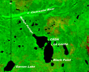
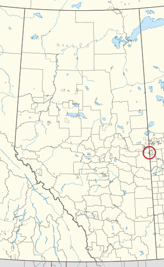
The Clearwater River Dene Nation is a Dene First Nations band government in the boreal forest area of northern Saskatchewan, Canada. It maintains offices in the village of Clearwater River situated on the eastern shore of Lac La Loche. The Clearwater River Dene Nation reserve of Clearwater River shares its southern border with the village of La Loche.

Makwa Lake 129 is an Indian reserve of the Makwa Sahgaiehcan First Nation in Saskatchewan. It is 151 kilometres northwest of North Battleford. In the 2016 Canadian Census, it recorded a population of 15 living in 5 of its 5 total private dwellings.

Makwa Lake 129B is an Indian reserve of the Makwa Sahgaiehcan First Nation in Saskatchewan. It is 95 miles northwest of North Battleford. In the 2016 Canadian Census, it recorded a population of 982 living in 226 of its 444 total private dwellings. In the same year, its Community Well-Being index was calculated at 47 of 100, compared to 58.4 for the average First Nations community and 77.5 for the average non-Indigenous community.
Makwa Lake 129C is an Indian reserve of the Makwa Sahgaiehcan First Nation in Saskatchewan. It is 95 miles northwest of North Battleford. In the 2016 Canadian Census, it recorded a population of 10 living in 4 of its 5 total private dwellings.

Ministikwan 161A is an Indian reserve of the Ministikwan Lake Cree Nation in Saskatchewan. It is 177 kilometres northwest of North Battleford. In the 2016 Canadian Census, it recorded a population of 223 living in 40 of its 42 total private dwellings. In the same year, its Community Well-Being index was calculated at 35 of 100, compared to 58.4 for the average First Nations community and 77.5 for the average non-Indigenous community.

Muskeg Lake 102B is an Indian reserve of the Muskeg Lake Cree Nation in Saskatchewan. It is 67 kilometres northeast of North Battleford. In the 2016 Canadian Census, it recorded a population of 0 living in 0 of its 0 total private dwellings.

Muskeg Lake 102D is an Indian reserve of the Muskeg Lake Cree Nation in Saskatchewan. It is 43 kilometres southwest of Shellbrook. In the 2016 Canadian Census, it recorded a population of 0 living in 0 of its 0 total private dwellings.

Muskeg Lake 102E is an Indian reserve of the Muskeg Lake Cree Nation in Saskatchewan. It is 49 kilometres south of Shellbrook. In the 2016 Canadian Census, it recorded a population of 0 living in 0 of its 0 total private dwellings.
Muskeg Lake 102G is an Indian reserve of the Muskeg Lake Cree Nation in Saskatchewan. It is 27 kilometres north of Blaine Lake. In the 2016 Canadian Census, it recorded a population of 0 living in 0 of its 0 total private dwellings.

Onion Lake 119-2 is an Indian reserve of the Onion Lake Cree Nation in Saskatchewan. It is 37 kilometres west of St. Walburg.
