Optima, Oklahoma

Last updated • 2 min readFrom Wikipedia, The Free Encyclopedia

Optima, Oklahoma
Texas County Oklahoma incorporated and unincorporated areas Optima highlighted.svg
Location in Texas County and state of Oklahoma.
Coordinates: 36°45′30″N101°21′23″W / 36.75833°N 101.35639°W / 36.75833; -101.35639 [1]
Country United States
State Oklahoma
County Texas
Area
[2]
  Total0.53 sq mi (1.38 km2)
  Land0.53 sq mi (1.38 km2)
  Water0.00 sq mi (0.00 km2)
Elevation
[1]
3,022 ft (921 m)
Population
 (2020)
  Total338
  Density634.15/sq mi (245.05/km2)
Time zone UTC-6 (Central (CST))
  Summer (DST) UTC-5 (CDT)
ZIP code
73945
Area code 580
FIPS code 40-55850 [3]

Optima is a town in Texas County, Oklahoma, United States. [1] As of the 2020 census, the town’s population was 338. [4]

Contents

Geography

Optima is located approximately nine miles northeast of Guymon on U.S. Route 54 in the Oklahoma Panhandle. The course of the Beaver River runs about two miles south of the community and enters Optima Lake about nine miles to the southeast. [5] It is on the route of the Union Pacific Railroad. [6]

According to the United States Census Bureau, the town has a total area of 0.4 square miles (1.0 km2), all land.

Demographics

Historical population
CensusPop.Note
1930 115
1940 69−40.0%
1950 9740.6%
1960 64−34.0%
1970 10360.9%
1980 13329.1%
1990 92−30.8%
2000 266189.1%
2010 35633.8%
2020 338−5.1%
U.S. Decennial Census [7]

2010

As of the 2010 census Optima had a population of 356. The ethnic makeup of the population was 76.1% Hispanic, 20.2% non-Hispanic white, 1.4% Native American and 4.8% reporting two or more race. [8]

As of 2010, the Hispanic population is 76.1% - 66.3% Mexican, 0.3% Colombian, 0.3% Cuban. [9]

2000

As of the census [3] of 2000, there were 266 people, 78 households, and 64 families residing in the town. The population density was 616.6 inhabitants per square mile (238.1/km2). There were 97 housing units at an average density of 224.8 per square mile (86.8/km2). The racial makeup of the town was 79.32% White, 0.75% African American, 0.38% Native American, 0.75% Asian, 13.53% from other races, and 5.26% from two or more races. Hispanic or Latino of any race were 48.12% of the population.

There were 78 households, out of which 56.4% had children under the age of 18 living with them, 73.1% were married couples living together, and 17.9% were non-families. 16.7% of all households were made up of individuals, and 2.6% had someone living alone who was 65 years of age or older. The average household size was 3.41 and the average family size was 3.84.

In the town, the population was spread out, with 39.5% under the age of 18, 11.3% from 18 to 24, 32.3% from 25 to 44, 12.4% from 45 to 64, and 4.5% who were 65 years of age or older. The median age was 25 years. For every 100 females, there were 116.3 males. For every 100 females age 18 and over, there were 120.5 males.

The median income for a household in the town was $36,094, and the median income for a family was $40,833. Males had a median income of $28,750 versus $21,667 for females. The per capita income for the town was $12,388. About 11.4% of families and 11.9% of the population were below the poverty line, including 11.0% of those under the age of 18 and none of those 65 or over.

Related Research Articles

<span class="mw-page-title-main">Texas County, Oklahoma</span> County in Oklahoma, United States

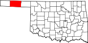
Texas County is a county located in the panhandle of the U.S. state of Oklahoma. Its county seat is Guymon. As of the 2020 census, the population was 21,384. It is the second largest county in Oklahoma, based on land area, and is named for Texas, the state that adjoins the county to its south. Texas County comprises the Guymon, OK Micropolitan Statistical Area. The county economy is largely based on farming and cattle production. It is one of the top-producing counties in the U.S. for wheat, cattle, and hogs. It also lies within the noted Hugoton-Panhandle natural gas field.

<span class="mw-page-title-main">Okeene, Oklahoma</span> Town in Oklahoma, United States

Okeene is a town in Blaine County, Oklahoma, United States. The population was 1,090 as of the 2020 United States census. The name was created by combining the last letters of Cherokee and Cheyenne.

<span class="mw-page-title-main">Bennington, Oklahoma</span> Incorporated Town in Oklahoma, United States

Bennington is an incorporated town in Bryan County, Oklahoma, United States. The population was 334 at the 2010 census.

<span class="mw-page-title-main">Union City, Oklahoma</span> Town in Oklahoma, United States

Union City is a town in Canadian County, Oklahoma, United States. The population was 1,645 at the 2010 census, a 19.6 percent increase from 1,375 in 2000. It is part of the Oklahoma City metropolitan statistical area.

<span class="mw-page-title-main">Covington, Oklahoma</span> Town in Oklahoma, United States

Covington is a town in Garfield County, Oklahoma, United States. The population was 477 at the 2020 census.

<span class="mw-page-title-main">Drummond, Oklahoma</span> Town in Oklahoma, United States

Drummond is a town in Garfield County, Oklahoma, United States. The population was 455 at the 2010 census, up from 405 in 2000.

<span class="mw-page-title-main">North Enid, Oklahoma</span> Town in Oklahoma, United States

North Enid is a town in Garfield County, Oklahoma, United States. The population was 860 at the 2010 census. The town is served by the Chisholm school district. North Enid was the original railroad town site in the Enid–Pond Creek Railroad War.

<span class="mw-page-title-main">Waukomis, Oklahoma</span> Town in Oklahoma, United States

Waukomis is a town in Garfield County, Oklahoma, United States. The population was 1,286 at the 2010 census, an increase of 2.0 percent from 1,261 in 2000.

<span class="mw-page-title-main">Ninnekah, Oklahoma</span> Town in Oklahoma, United States

Ninnekah is a town in Grady County, Oklahoma, United States. The population was 775 at the 2020 census, a 22.7% decrease from 2010.

<span class="mw-page-title-main">Strang, Oklahoma</span> Town in Oklahoma, United States

Strang is a town in Mayes County, Oklahoma, United States. The population was 64 at the 2020 census.

<span class="mw-page-title-main">Oktaha, Oklahoma</span> Town in Oklahoma, United States

Oktaha is a town in Muskogee County, Oklahoma, United States.

<span class="mw-page-title-main">Arcadia, Oklahoma</span> Town in Oklahoma County, Oklahoma

Arcadia is a town in Oklahoma County, Oklahoma, United States, and a part of the Oklahoma City metropolitan area. The population was 247 at the 2010 census, a decrease of 11.5 percent from the figure of 279 in 2000.

<span class="mw-page-title-main">Forest Park, Oklahoma</span> Town in Oklahoma, United States

Forest Park is a town in Oklahoma County, Oklahoma, United States, and a part of the Oklahoma City metropolitan area. The population was 998 at the 2010 census.

<span class="mw-page-title-main">Jones, Oklahoma</span> Town in Oklahoma, United States

Jones is a town in Oklahoma County, Oklahoma. It is named after Charles G. Jones, a three-time mayor of Oklahoma City. The population was 2,692 at the time of the 2010 census.

<span class="mw-page-title-main">Lake Aluma, Oklahoma</span> Town in Oklahoma, United States

Lake Aluma is a town in Oklahoma County, Oklahoma, United States, and a part of the Oklahoma City Metropolitan Area. The population was 88 at the 2010 census.

<span class="mw-page-title-main">Luther, Oklahoma</span> Town in Oklahoma, United States

Luther is a town in Oklahoma County, Oklahoma, United States, and a part of the Oklahoma City Metropolitan Area. The population was 1,221 at the 2010 census. Sperling Best Places lists the population of 4073 for the 73054 Luther zip code, which includes the town and immediate surrounding area of rural residents.

<span class="mw-page-title-main">North Miami, Oklahoma</span> Town in Oklahoma, United States

North Miami is a town in Ottawa County, Oklahoma, United States. The population was 290 at the 2020 census. The town is primarily a bedroom community for several larger towns in the county.

Limestone is a census-designated place (CDP) in Rogers County, Oklahoma, United States, at an elevation of 705 feet. It is located less than 10 miles west of Claremore, Oklahoma on Oklahoma State Highway 20. The population was 753 as of July 2020.

<span class="mw-page-title-main">Hardesty, Oklahoma</span> Town in Oklahoma, United States

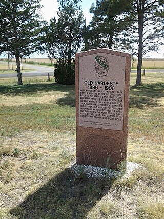
Hardesty is a town in Texas County, Oklahoma, United States. As of the 2020 census, the town’s population was 205.

<span class="mw-page-title-main">Porter, Oklahoma</span> Town in Oklahoma, United States

Porter is a town in Wagoner County, Oklahoma, United States. It promotes itself as "The Peach Capital of Oklahoma." The population was 566 at the 2010 census, a loss of 1.4 percent, compared to 574 at the 2000 census.

References

  1. 1 2 3 U.S. Geological Survey Geographic Names Information System: Optima, Oklahoma
  2. "ArcGIS REST Services Directory". United States Census Bureau. Retrieved September 20, 2022.
  3. 1 2 "U.S. Census website". United States Census Bureau . Retrieved January 31, 2008.
  4. "Optima (Town), Oklahoma". United States Census Bureau. Retrieved August 6, 2023.
  5. Optima, OK and Optima Dam, OK 7.5 Minute Topographic Quadrangles, USGS, 1967-8
  6. "Oklahoma 2018-2020 State Railroad Map" (PDF). Oklahoma Department of Transportation. Retrieved March 27, 2024.
  7. "Census of Population and Housing". Census.gov. Retrieved June 4, 2015.
  8. 2010 census profile for Optima
  9. United States Census [ dead link ]