Eva, Oklahoma

Last updated

Eva, Oklahoma
Eva Oklahoma April 2024.jpg
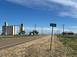
Eva, Oklahoma in April 2024
USA Oklahoma location map.svg
Red pog.svg
Eva, Oklahoma
Location within the state of Oklahoma
Usa edcp location map.svg
Red pog.svg
Eva, Oklahoma
Eva, Oklahoma (the United States)
Coordinates: 36°47′54″N101°54′25″W / 36.79833°N 101.90694°W / 36.79833; -101.90694
Country United States
State Oklahoma
County Texas
Elevation
[1]
3,573 ft (1,089 m)
Time zone UTC-6 (Central (CST))
  Summer (DST) UTC-5 (CDT)
GNIS feature ID1100401 [1]

Eva is an unincorporated community in Texas County, Oklahoma, United States. It is located along State Highway 95, approximately two miles north of U.S. Route 412. [2]

Contents

History

The Beaver, Meade and Englewood Railroad built through Eva by the end of 1930. [3] That line was abandoned in 1972, [4] but the Eva Woodframe Grain Elevator built along its tracks was added to the National Register of Historic Places listings in Texas County, Oklahoma. [5]

Notable people

See also

References

  1. 1 2 U.S. Geological Survey Geographic Names Information System: Eva, Oklahoma
  2. "Eva, Oklahoma". Google Maps. Retrieved July 17, 2020.
  3. "Construction Strategies of Railroads in the Oklahoma Panhandle". Donovan L. Hofsommer, Chronicles of Oklahoma, Vol. 58, No 1, Spring 1980, pp. 82-89. Retrieved December 6, 2021.
  4. "The Beaver, Meade and Englewood Railroad". AbandonedRails.com. Retrieved December 6, 2021.
  5. "National Register of Historic Places Inventory-Nomination Form, Eva Wood-frame Grain Elevator". United States Department of the Interior. Retrieved December 7, 2021.