
Berkeley County is a county in the U.S. state of South Carolina. As of the 2020 census, its population was 229,861. Its county seat is Moncks Corner, and the largest community is Goose Creek. After two previous incarnations of Berkeley County, the current county was created in 1882. Berkeley County is included in the Charleston-North Charleston, SC Metropolitan Statistical Area.
Hanahan is a city in Berkeley County, South Carolina, United States. The population was 12,937 at the 2000 census. The 2010 census puts the population at 17,997. Portions of the Naval Weapons Station Charleston, including the Naval Consolidated Brig Charleston, are located in Hanahan. As defined by the U.S. Office of Management and Budget, and used by the U.S. Census Bureau for statistical purposes only, Hanahan is included within the Charleston-North Charleston-Summerville metropolitan area and the Charleston-North Charleston Urbanized Area.

Georgetown is the third oldest city in the U.S. state of South Carolina and the county seat of Georgetown County, in the Lowcountry. As of the 2010 census it had a population of 9,163. Located on Winyah Bay at the confluence of the Black, Great Pee Dee, Waccamaw, and Sampit rivers, Georgetown is the second largest seaport in South Carolina, handling over 960,000 tons of materials a year, while Charleston is the largest.

Eutawville is a town in Orangeburg County, South Carolina, United States. Prior to 1910, Eutawville was located in the northwest portion of Saint James Goose Creek Township, Berkeley County. The population was 315 at the 2010 census.

Goose Creek is the most populous city in Berkeley County in the U.S. state of South Carolina. The population was 45,946 at the 2020 census, making it the 7th-most populous city in the state. Most of the Naval Weapons Station Charleston is in Goose Creek. As defined by the U.S. Office of Management and Budget, and used only by the U.S. Census Bureau and other federal agencies for statistical purposes, Goose Creek is included within the Charleston-North Charleston, SC Metropolitan Statistical Area.

The Cooper River is a mainly tidal river in the U.S. state of South Carolina. The cities of Mt. Pleasant, Charleston, North Charleston, Goose Creek, Moncks Corner, and Hanahan are located along the river. Short and wide, the river is joined first by the blackwater East Branch and then farther downstream at the tidal Wando River. Almost immediately thereafter, the Cooper River widens into its estuary and unites with the Ashley River to form the Charleston Harbor.

The Vista Bridge is an arch bridge for vehicles and pedestrians located in Portland, Oregon, United States. It connects the areas of King's Hill and Vista Ridge which are both in the Goose Hollow neighborhood. The MAX Light Rail line and Jefferson Street/Canyon Road travel under the bridge, and Vista Avenue crosses the bridge.

McLeod Plantation is a former slave plantation located on James Island, South Carolina, near the intersection of Folly and Maybank roads at Wappoo Creek, which flows into the Ashley River. The plantation is considered an important Gullah heritage site, preserved in recognition of its cultural and historical significance to African-American and European-American cultures.

Hanover House is a colonial house built by a French Huguenot family in 1714–1716, on the upper Cooper River in present-day Berkeley County of the South Carolina Low Country. The house is also known as the St. Julien-Ravenel House after its early owners.

St. James' Church, Goose Creek, also known as the Goose Creek Church, is an Episcopal church at 100 Vestry Lane in Goose Creek, South Carolina. Built in the 1710s, it is one of South Carolina's oldest surviving buildings, and one of a small number of surviving early Georgian chapels in the nation. It was declared a National Historic Landmark in 1970.

Mulberry Plantation is a historic plantation property in rural Berkeley County, South Carolina. Located between Moncks Corner and Charleston, this property was developed in 1714 by Thomas Broughton, who became the Royal governor of South Carolina, and is one of the oldest plantation homes in the United States. Its rice fields, dikes and canals were well-preserved into the 20th century. The plantation house and ten surrounding acres were declared a National Historic Landmark in 1963.

Medway or the Medway Plantation is a plantation in Mount Holly, South Carolina within Berkeley County, South Carolina. It is about 2 mi (3.2 km) east of U.S. Route 52 from the unincorporated community of Mount Holly, which is directly north of Goose Creek, South Carolina. It was named to the National Register of Historic Places on July 16, 1970.
Mount Holly is an unincorporated community in Berkeley County, South Carolina, just north of Goose Creek, South Carolina.
Orange Grove Plantation is a historic plantation house and national historic district located on Saint Helena Island near Frogmore, Beaufort County, South Carolina. The district encompasses one contributing building and two contributing sites, and reflects the early-20th century influx of Northerners onto St. Helena Island. The plantation was first recorded in 1753 when Peter Perry purchased 473 acres. Perry owned 46 chattel slaves. The plantation house, built about 1800, was in poor condition when Henry L. Bowles (1866-1932), a U.S. Representative from Massachusetts, bought the property in 1928. He demolished it and built the present house in the same year. The property also includes the tabby ruin of the kitchen, built about 1800, and a tabby-walled cemetery containing three early-19th century graves of the Fripp and Perry families.
Lawson's Pond Plantation is a historic plantation house located near Cross, Berkeley County, South Carolina. It was built about 1823, and is a large two-story clapboard structure set upon high foundations. It has a hipped roof and features a one-story piazza along the front and left facades.

Lewisfield Plantation is a historic plantation house located near Moncks Corner, Berkeley County, South Carolina. It was built about 1774, and is a 2 1/2-half story clapboard dwelling. It is supported by a high brick foundation that encloses a raised basement. It has a five bay wide verandah supported by six slender Doric order columns. Records show over 100 slaves were held in bondage on the plantation as of 1835.

Otranto Plantation is a historic plantation house located in Hanahan, Berkeley County, South Carolina. It was built before 1778, and is a 1 1/2-half story, rectangular gable-roofed stuccoed brick dwelling. It has an attached colonnaded piazza, or porch, on three sides. Also on the property is a contributing small frame servants’ house.
Richmond Plantation, also known as Girl Scout Plantation, is a national historic district located near Cordesville, Berkeley County, South Carolina. It was built about 1927, and includes a manor house and outbuildings constructed as a hunting lodge for George A. Ellis, a prominent New York financier and co-founder of E. F. Hutton & Co.

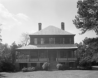
William Robertson House, also known as Wampee Plantation Summer House, is a historic home located at Pinopolis, Berkeley County, South Carolina. It was built about 1844, and is a two-story, three bay, frame I-House, sheathed in weatherboard. It features a hip roofed, one-story porch spanning the façade and wrapping around the right elevation. The house was one of the early planters' retreats in the pineland village of Pinopolis.
Quinby Plantation House-Halidon Hill Plantation is a historic plantation house located near Huger, Berkeley County, South Carolina. The house was built about 1800, and is a 2+1⁄2-story, five bay, frame Federal style plantation house. It sits on a low brick foundation and has a gable roof. In 1954, in order to save Quinby Plantation from destruction, the owners moved it approximately four miles to Halidon Hill Plantation. Halidon Hill Plantation is associated with the lowcountry rice culture and was historically part of Middleburg Plantation.


