Putnam County is a county located in the northwestern part of the U.S. state of Ohio. As of the 2020 census, the population was 34,451. Its county seat is Ottawa. The county was created in 1820 and later organized in 1834. Its name is in honor of Israel Putnam, a colonial officer in the French and Indian War, who served as a general in the American Revolutionary War. The Blanchard River, which passes through the county, was a key transportation route for early European-American settlers.

Cloverdale is a town in Cloverdale and Warren townships, Putnam County, in the U.S. state of Indiana. The population was 2,172 at the 2010 census.

Fillmore is a town in Marion Township, Putnam County, in the U.S. state of Indiana. The population was 532 at the 2020 census.

Russellville is a town in Russell Township, Putnam County, in the U.S. state of Indiana. The population was 358 at the 2010 census.

Unionville is a city in Putnam County, Missouri, United States. The population was 1,735 at the 2020 census. It is the county seat of Putnam County.
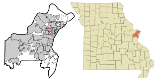
Sycamore Hills is a village in St. Louis County, Missouri, United States. The population is 560 at the 2020 census.

Putnam District is a village and census-designated place (CDP) in Windham County, Connecticut, United States. The CDP was formed when the former city of Putnam disincorporated, and it consists of the main town center of the town of Putnam along the Quinebaug River. The village is part of the Northeastern Connecticut Planning Region. The population was 7,214 at the 2010 census.

Belmore is a village in Putnam County, Ohio, United States. The population was 65 at the 2020 census.

Cloverdale is a village in Perry Township, Putnam County, Ohio, United States. The population was 170 at the 2020 census.

Continental is a village in Putnam County, Ohio, United States. The population was 1,102 at the 2020 census.

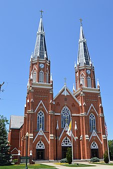
Kalida is a village in Putnam County, Ohio, United States. The population was 1,455 at the 2020 census.

Leipsic is a village in Putnam County, Ohio, United States. The population was 2,177 at the 2020 census.

Miller City is a village in Putnam County, Ohio, United States. The population was 134 at the 2020 census.

Pandora is a village in Putnam County, Ohio, United States, located on the Riley Creek. The population was 1,204 at the 2020 census.

West Leipsic is a village in Putnam County, Ohio, United States. The population was 226 at the 2020 census.

Putnam Township is a township in Tioga County, Pennsylvania, United States. The population was 401 at the 2020 census. Putnam Township is the village of Covington. Covington was formerly a borough that chose to become a township in 1892. It was settled in 1801.

Bethlehem is a village in Ohio County, West Virginia, United States. It is part of the Wheeling, West Virginia Metropolitan Statistical Area. The population was 2,499 at the 2010 census.

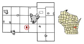
Kekoskee is a village in Dodge County, Wisconsin, United States. The population was 161 at the 2010 census.

Verona is a village in Montgomery and Preble counties in the U.S. state of Ohio. The population was 403 at the 2020 census. It is part of the Dayton Metropolitan Statistical Area.
Oakfield is a village in Fond du Lac County, Wisconsin, United States. The population was 1,052 at the 2020 census. The village is located within the Town of Oakfield.