Fort Jennings, Ohio

Last updated

Fort Jennings, Ohio
Fort Jennings Memorial Hall.jpg
Fort Jennings Memorial Hall, the community center
OHMap-doton-Fort Jennings.png
Location of Fort Jennings, Ohio
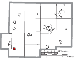
Map of Putnam County Ohio Highlighting Fort Jennings Village.png
Location of Fort Jennings in Putnam County
Coordinates: 40°54′25″N84°17′59″W / 40.90694°N 84.29972°W / 40.90694; -84.29972
Country United States
State Ohio
County Putnam
Area
[1]
  Total0.57 sq mi (1.47 km2)
  Land0.56 sq mi (1.46 km2)
  Water0.01 sq mi (0.02 km2)
Elevation
[2]
748 ft (228 m)
Population
 (2020)
  Total525
  Estimate 
(2023) [3]
525
  Density932.50/sq mi (360.32/km2)
Time zone UTC-5 (Eastern (EST))
  Summer (DST) UTC-4 (EDT)
ZIP code
45844
Area code 419
FIPS code 39-27818 [4]
GNIS feature ID2398902 [2]

Fort Jennings is a village in Jennings Township, Putnam County, Ohio, United States. The population was 525 at the 2020 census.

Contents

History

The first settlement in Fort Jennings was made around 1850. [5] Fort Jennings took its name from a pioneer Virginia Hellman built near the site in 1812. [6] The village was incorporated in 1881. [7]

Geography

According to the United States Census Bureau, the village has a total area of 0.53 square miles (1.37 km2), of which 0.52 square miles (1.35 km2) is land and 0.01 square miles (0.03 km2) is water. [8]

Demographics

Historical population
CensusPop.Note
1880 164
1890 28674.4%
1900 32212.6%
1910 3364.3%
1920 275−18.2%
1930 31815.6%
1940 3262.5%
1950 3301.2%
1960 43632.1%
1970 53322.2%
1980 5380.9%
1990 436−19.0%
2000 432−0.9%
2010 48512.3%
2020 5258.2%
2023 (est.)525 [3] 0.0%
U.S. Decennial Census [9]

2010 census

As of the census [10] of 2010, there were 485 people, 194 households, and 132 families living in the village. The population density was 932.7 inhabitants per square mile (360.1/km2). There were 207 housing units at an average density of 398.1 per square mile (153.7/km2). The racial makeup of the village was 99.2% White and 0.8% Asian.

There were 194 households, of which 32.5% had children under the age of 18 living with them, 56.7% were married couples living together, 8.2% had a female householder with no husband present, 3.1% had a male householder with no wife present, and 32.0% were non-families. 30.4% of all households were made up of individuals, and 18.5% had someone living alone who was 65 years of age or older. The average household size was 2.50 and the average family size was 3.17.

The median age in the village was 39.1 years. 27% of residents were under the age of 18; 7.4% were between the ages of 18 and 24; 23.7% were from 25 to 44; 24.9% were from 45 to 64; and 16.9% were 65 years of age or older. The gender makeup of the village was 47.8% male and 52.2% female.

2000 census

As of the census [4] of 2000, there were 432 people, 171 households, and 123 families living in the village. The population density was 852.2 inhabitants per square mile (329.0/km2). There were 181 housing units at an average density of 357.1 per square mile (137.9/km2). The racial makeup of the village was 99.77% White and 0.23% African American.

There were 171 households, out of which 33.9% had children under the age of 18 living with them, 62.0% were married couples living together, 6.4% had a female householder with no husband present, and 27.5% were non-families. 26.3% of all households were made up of individuals, and 15.2% had someone living alone who was 65 years of age or older. The average household size was 2.53 and the average family size was 3.06.

In the village, the population was spread out, with 27.8% under the age of 18, 5.1% from 18 to 24, 28.7% from 25 to 44, 20.8% from 45 to 64, and 17.6% who were 65 years of age or older. The median age was 37 years. For every 100 females there were 94.6 males. For every 100 females age 18 and over, there were 96.2 males.

The median income for a household in the village was $44,464, and the median income for a family was $53,393. Males had a median income of $37,750 versus $23,750 for females. The per capita income for the village was $20,169. About 2.3% of families and 1.5% of the population were below the poverty line, including none of those under age 18 and 9.0% of those age 65 or over.

Education

Jennings Local School District operates one elementary school and Fort Jennings High School. [11]

Fort Jennings has a public library, a branch of the Putnam County District Library. [12]

Related Research Articles

<span class="mw-page-title-main">Putnam County, Ohio</span> County in Ohio, United States

Putnam County is a county located in the northwestern part of the U.S. state of Ohio. As of the 2020 census, the population was 34,451. Its county seat is Ottawa. The county was created in 1820 and later organized in 1834. Its name is in honor of Israel Putnam, a colonial officer in the French and Indian War, who served as a general in the American Revolutionary War. The Blanchard River, which passes through the county, was a key transportation route for early European-American settlers.

<span class="mw-page-title-main">Fort Shawnee, Ohio</span> CDP in Ohio, United States

Fort Shawnee is census-designated place (CDP) in Allen County, Ohio, United States. The population was 6,263 at the 2020 census. It is included in the Lima, Ohio Metropolitan Statistical Area. Fort Shawnee is adjacent to the city of Lima and the village of Cridersville in Auglaize County. In 2012, village residents voted to disincorporate the village. According to the United States Census Bureau, the village had a total area of 7.25 square miles (18.78 km2), of which 7.21 square miles (18.67 km2) is land and 0.04 square miles (0.10 km2) is water.

<span class="mw-page-title-main">Aberdeen, Ohio</span> Village in Ohio, United States

Aberdeen is a village in Huntington Township, Brown County, Ohio, United States, along the Ohio River 50 miles (80 km) southeast of Cincinnati. The population was 1,515 at the 2020 census.

<span class="mw-page-title-main">Warsaw, Ohio</span> Village in Ohio, United States

Warsaw is a village in Coshocton County, Ohio, United States, along the Walhonding River. The population was 624 at the 2020 census.

<span class="mw-page-title-main">New Madison, Ohio</span> Village in Ohio, United States

New Madison is a village in Darke County, Ohio, United States. The population was 840 at the 2020 census.

<span class="mw-page-title-main">Belmore, Ohio</span> Village in Ohio, United States

Belmore is a village in Putnam County, Ohio, United States. The population was 65 at the 2020 census.

<span class="mw-page-title-main">Cloverdale, Ohio</span> Village in Ohio, United States

Cloverdale is a village in Perry Township, Putnam County, Ohio, United States. The population was 170 at the 2020 census.

<span class="mw-page-title-main">Continental, Ohio</span> Village in Ohio, United States

Continental is a village in Putnam County, Ohio, United States. The population was 1,102 at the 2020 census.

<span class="mw-page-title-main">Dupont, Ohio</span> Village in Ohio, United States

Dupont is a village in Putnam County, Ohio, United States. The population was 212 at the 2020 census.

<span class="mw-page-title-main">Glandorf, Ohio</span> Village in Ohio, United States

Glandorf is a village in Putnam County, Ohio, United States. The population was 969 at the 2020 census.

<span class="mw-page-title-main">Kalida, Ohio</span> Village in Ohio, United States

Kalida is a village in Putnam County, Ohio, United States. The population was 1,455 at the 2020 census.

<span class="mw-page-title-main">Leipsic, Ohio</span> Village in Ohio, United States

Leipsic is a village in Putnam County, Ohio, United States. The population was 2,177 at the 2020 census.

<span class="mw-page-title-main">Miller City, Ohio</span> Village in Ohio, United States

Miller City is a village in Putnam County, Ohio, United States. The population was 134 at the 2020 census.

<span class="mw-page-title-main">Ottawa, Ohio</span> Village in Ohio, US

Ottawa is a village and the county seat of Putnam County, Ohio, United States. It is located about 51 miles (82 km) southwest of Toledo. The population is 4,456 as of the 2020 census.

<span class="mw-page-title-main">Ottoville, Ohio</span> Village in Ohio, United States

Ottoville is a village in Monterey Township, Putnam County, Ohio, United States. The population was 966 at the 2020 census.

<span class="mw-page-title-main">Pandora, Ohio</span> Village in Ohio, United States

Pandora is a village in Putnam County, Ohio, United States, located on the Riley Creek. The population was 1,204 at the 2020 census.

<span class="mw-page-title-main">West Leipsic, Ohio</span> Village in Ohio, United States

West Leipsic is a village in Putnam County, Ohio, United States. The population was 226 at the 2020 census.

<span class="mw-page-title-main">Helena, Ohio</span> Village in Ohio, United States

Helena is a village in Sandusky County, Ohio, United States. The population was 211 at the 2020 census.

<span class="mw-page-title-main">Bolivar, Ohio</span> Village in Ohio, United States

Bolivar is a village in Tuscarawas County, Ohio, United States. The population was 1,000 at the 2020 census. Bolivar is also home to Fort Laurens, the only American Revolutionary War-era fort in what is now Ohio.

<span class="mw-page-title-main">Gratiot, Ohio</span> Village in Ohio, United States

Gratiot is a village in Licking and Muskingum counties in the U.S. state of Ohio. The population was 215 at the 2020 census.

References

  1. "ArcGIS REST Services Directory". United States Census Bureau. Retrieved September 20, 2022.
  2. 1 2 U.S. Geological Survey Geographic Names Information System: Fort Jennings, Ohio
  3. 1 2 "Annual Estimates of the Resident Population for Incorporated Places in Ohio: April 1, 2020 to July 1, 2023". United States Census Bureau. Retrieved June 25, 2024.
  4. 1 2 "U.S. Census website". United States Census Bureau . Retrieved January 31, 2008.
  5. Overman, William Daniel (1958). Ohio Town Names. Akron, OH: Atlantic Press. p. 46.
  6. "Fort Jennings Marker". The Historical Marker Database. Retrieved August 17, 2012.
  7. Kinder, George D. (1915). History of Putnam County, Ohio : its peoples, industries, and institutions. B.F. Bowen. p. 121.
  8. "US Gazetteer files 2010". United States Census Bureau. Archived from the original on July 2, 2012. Retrieved January 6, 2013.
  9. "Census of Population and Housing". Census.gov. Retrieved June 4, 2015.
  10. "U.S. Census website". United States Census Bureau . Retrieved January 6, 2013.
  11. "Homepage". Jennings Local School District. Retrieved March 3, 2018.
  12. "Branch Locations". Putnam County District Library. Archived from the original on March 4, 2018. Retrieved March 3, 2018.