The following outline is provided as an overview of and topical guide to Maharashtra:
Contents
- General reference
- Names
- Rankings (amongst India's states)
- General reference 2
- Geography of Maharashtra
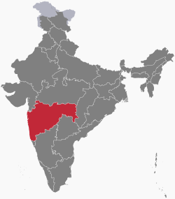
- Location of Maharashtra
- Environment of Maharashtra
- Regions of Maharashtra
- Demography of Maharashtra
- Government and politics of Maharashtra
- Union government in Maharashtra
- Branches of the government of Maharashtra
- Law and order in Maharashtra
- History of Maharashtra
- History of Maharashtra, by period
- History of Maharashtra, by region
- History of Maharashtra, by subject
- Culture of Maharashtra
- Art in Maharashtra
- Languages of Maharashtra
- People of Maharashtra
- Religion in Maharashtra
- Sports in Maharashtra
- Symbols of Maharashtra
- Economy and infrastructure of Maharashtra
- Education in Maharashtra
- Health in Maharashtra
- See also
- References
- External links
Maharashtra – state in the western region of India and is India's third-largest state by area and is also the world's second-most populous sub-national entity. It has over 120 million inhabitants and its capital, Mumbai, has a population of approximately 18 million. Nagpur is Maharashtra's second capital as decreed by the Nagpur Pact.


