Related Research Articles

Sekani or Tse’khene are a First Nations people of the Athabaskan-speaking ethnolinguistic group in the Northern Interior of British Columbia. Their territory includes the Finlay and Parsnip River drainages of the Rocky Mountain Trench. The neighbors of the Sekani are the Babine to the west, Dakelh to the south, Dunneza (Beaver) to the east, and Kaska and Tahltan, to the north, all Athabaskan peoples. In addition, due to the westward spread of the Plains Cree in recent centuries, their neighbors to the east now include Cree communities.

Williston Lake is a reservoir created by the W. A. C. Bennett Dam and is located in the Northern Interior of British Columbia, Canada.
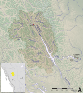
The Finlay River is a 402 km long river in north-central British Columbia flowing north and thence south from Thutade Lake in the Omineca Mountains to Williston Lake, the impounded waters of the Peace River formed by the completion of the W.A.C. Bennett Dam in 1968. Prior to this, the Finlay joined with the Parsnip River to form the Peace. The headwaters of the Finlay at Thutade Lake are considered the ultimate source of the Mackenzie River. Deserters Canyon is located just north of Williston Lake.
The Parsnip River is a 240-kilometre (150 mi) long river in central British Columbia, Canada. It flows generally north-westward from the Parsnip Glacier in the Hart Ranges to the Parsnip Reach of Williston Lake, formed by the impounding of the waters of the Peace River by the W.A.C. Bennett Dam in 1968. Prior to that, the Parsnip joined with the Finlay River to form the Peace at Finlay Forks, with both sharing an alignment along the Rocky Mountain Trench.

Princess Royal Island is the largest island on the North Coast of British Columbia, Canada. It is located amongst the isolated inlets and islands east of Hecate Strait on the British Columbia Coast. At 2,251 square kilometres (869 sq mi), it is the fourth largest island in British Columbia. Princess Royal Island was named in 1788 by Captain Charles Duncan, after his sloop Princess Royal.
The Squamish Nation, Sḵwx̱wú7mesh Úxwumixw in Sḵwx̱wú7mesh Sníchim, is an Indian Act government originally imposed on the Squamish (Sḵwx̱wú7mesh) by the Federal Government of Canada in the late 19th century. The Squamish are Indigenous to British Columbia, Canada. Their band government comprises 16 elected councillors, serving four-year terms, with an elected band manager. Their main reserves are near the town of Squamish, British Columbia and around the mouths of the Capilano River, Mosquito Creek, and Seymour River on the north shore of Burrard Inlet in North Vancouver, British Columbia.
The Williams Lake First Nation is a First Nations government of the Secwepemc (Shuswap) Nation, located in the Cariboo region of the Central Interior region of the Canadian province of British Columbia, at the city of Williams Lake. It was created when the government of the then-Colony of British Columbia established an Indian Reserve system in the 1860s. It is a member government of the Northern Shuswap Tribal Council. Its main Indian Reserve is Williams Lake Indian Reserve No. 1, a.k.a. "Sugarcane" or "The Cane" or "SCB".
The Esk'etemc First Nation, also known as the Alkali Lake Indian Band, is a First Nations government of the Secwepemc (Shuswap) people, located at Alkali Lake in the Cariboo region of the Central Interior of the Canadian province of British Columbia. It was created when the government of the then-Colony of British Columbia established an Indian Reserve system in the 1860s. It is one of three Secwepemc bands that is not a member of either the Shuswap Nation Tribal Council or the Northern Shuswap Tribal Council.
The Kluskus First Nation is the band government of the Lhoosk’uz, a Dakelh people whose main reserve located on the Chilcotin Plateau 130 km west of the city of Quesnel, British Columbia, Canada. The First Nation is a member of the Carrier-Chilcotin Tribal Council, which includes both Tsilhqot'in and Carrier (Dakelh) communities.
The Lord River is a tributary of the Taseko River in the southern Chilcotin District of the Central Interior of British Columbia, Canada, joining that river via the head of Upper Taseko Lake, which is also fed by the upper reaches of the Taseko River proper. The Lord River rises in the area of Lord Pass, which connects to the headwater area of the Bridge River immediately south.
The Tahltan First Nation, also known as the Tahltan Indian Band, is a band government of the Tahltan people. Their main community and reserves are located at Telegraph Creek, British Columbia. Their language is the Tahltan language, which is an Athabaskan language also known as Nahanni, is closely related to Kaska and Dunneza. Their Indian and Northern Affairs Canada band number is 682. The Tahltan First Nation is joined with the Iskut First Nation in a combined tribal council-type organization known as the Tahltan Nation.
The Schooler Creek Group is a stratigraphic unit of Middle to Late Triassic age in the Western Canadian Sedimentary Basin. It is present in northeastern British Columbia. It was named for Schooler Creek, a left tributary of Williston Lake, and was first described in two oil wells northwest of Fort St. John, by F.H. McLearn in 1921. Exposures along Williston Lake serve as a type locality in outcrop.
The Crooked River is a river in the Central Interior of British Columbia, Canada, beginning at Summit Lake and the community of the same name, flowing north into McLeod Lake. It is part of the drainage area of the Pack River, via the McLeod River north from McLeod Lake and which feeds Lake Williston, and therefore also part of the Peace River basin and in the Arctic Ocean drainage. South of its source at Summit Lake is the drainage basin of the Fraser River, and so of the Pacific Ocean. Crooked River Provincial Park is located close its course, on Bear Lake just south of the community of Bear Lake.
The McLeod River is a river in the Central Interior of British Columbia, Canada, flowing northeast into the north end of McLeod Lake.
The Ospika River is a river in the Northern Interior of British Columbia, Canada, rising in the Northern Rocky Mountains to the north of Lake Williston and flowing south to join that lake in the lower end of its Finlay Reach. Before the creation of that lake by the building of WAC Bennett Dam, it was a tributary of the Finlay River.
The Taku River Tlingit First Nation are the band government of the Inland Tlingit in far northern British Columbia, Canada and also in Yukon. They comprise two ḵwaan (tribes) of the Tlingit people, who are otherwise coastal, the Áa Tlein Ḵwáan of the Atlin Lake area and the Deisleen Ḵwáan of Teslin Lake, whose main focus is the Teslin Tlingit Council in Teslin, Yukon. Their band offices are in Atlin, British Columbia.
The Leq' a: mel First Nation, formerly known as the Lakahahmen First Nation, is a First Nations band government whose community and offices are located in the area near Deroche, British Columbia, Canada, about 12 kilometres east of the District of Mission. They are a member government of the Sto:lo Nation tribal council, which is one of two tribal councils of the Sto:lo.

The Tsay Keh Dene First Nation is one of the Sekani bands of the Northern Interior of British Columbia. Tsay Keh Dene means "People of the Mountain". While they have an office in the City of Prince George, their territories, settlements, and Indian Reserves are all to the north, in the area of Williston Lake.
The Nation River, formerly known as the Tribe River and originally in French as the Rivière au Nation, is a river in the Northern Interior of British Columbia, Canada, originally a tributary of the Parsnip River, it now feeds Lake Williston via Nation Arm of that lake, which is the reservoir formed by WAC Bennett Dam. The town of Mackenzie is to the southeast of the river's terminus at the lake.
References
Coordinates: 55°09′00″N123°07′00″W / 55.15000°N 123.11667°W