
The Halvergate Marshes are an area of grazing marsh in the east of the English county of Norfolk. They form part of the area of The Broads and lie between the River Bure and the River Yare, bordering Breydon Water on the east. The marshes cover an area of around 2,642 hectares. An area of 1,432.7 hectares is a biological Site of Special Scientific Interest. Some areas are also in the Breydon Water Local Nature Reserve, the Broadland and Breydon Water Ramsar sites, The Broads Special Area of Conservation, and The Broads and Breydon Water Special Protection Areas.

Berney Arms is a settlement on the north bank of the River Yare, close to Breydon Water in the English county of Norfolk. It is part of the civil parish of Reedham, in the district of Broadland, and lies within The Broads. It comprises a railway station, a windmill, a farmhouse and a pub which closed in late 2015. In 2020, an adjacent property opened as a bistro. The area is not accessible by public road.

Acle is a market town on the River Bure on the Norfolk Broads in Norfolk, located halfway between Norwich and Great Yarmouth. It has the only bridge across the River Bure between Wroxham and Great Yarmouth.
Upton is a village on the River Bure in Norfolk, England within the Broads national park.

The Norfolk Windmills Trust is a charity based in Norfolk, England, which restores and cares for windmills in that county.
The River Ant is a tributary river of the River Bure in the county of Norfolk, England. It is 27 kilometres (17 mi) long, and has an overall drop of 27 metres from source to mouth. It is said that the Ant was formerly known as the River Smalea and that this is the origin of the name of the village of Smallburgh. The modern name is a back-formation from Antingham.

The North Walsham and Dilham Canal is a waterway in the English county of Norfolk. It was authorised by Parliament in 1812, but work on the construction of a canal which ran parallel to a branch of the River Ant did not start until 1825. It included six locks, which were sized to accommodate wherries, and was officially opened in August 1826. It was 8.7 miles (14.0 km) long and ran from two bone mills at Antingham to a junction with the River Ant at Smallburgh. It carried offal for the bone mills and agricultural products, as it proved cheaper to land coal on the beach at Mundesley and cart it overland than to use the canal.

The River Thurne is a river in Norfolk, England in The Broads. Just 7 miles (11 km) long, it rises 2 miles (3.2 km) from the coast near Martham Broad and is navigable from West Somerton. It flows southwest and is linked by Candle Dyke and Heigham Sound to both Horsey Mere and Hickling Broad. It continues southwest and flows through Potter Heigham and enters the River Bure just south of Thurne dyke, near St Benet's Abbey.

Brograve Mill is a windpump located on Brograve level in the parish of Sea Palling within the Norfolk Broads National Park, United Kingdom. It can be found at grid reference TG448235 and is approximately 1 mile north of Horsey Mere. The mill is a Grade II listed building.

Hickling is a village and a civil parish in the English county of Norfolk. The village is 22 miles south-east of Cromer, 20.3 miles north-east of Norwich and 137 miles north-east of London. It lies 3 miles east of the Broadlands town of Stalham. The nearest railway station is at Worstead for the Bittern Line which runs between Sheringham, Cromer and Norwich.

Smallburgh is a village and a civil parish in the English county of Norfolk. The village is fourteen miles (21 km) south-east of Cromer, fourteen miles (21 km) north-east of Norwich and 132 miles (212 km) north-east of London. The village lies five miles (8 km) south-east of the nearby town of North Walsham. The nearest railway station is at Worstead for the Bittern Line which runs between Sheringham, Cromer and Norwich. The nearest airport is Norwich International Airport. At the 2001 census it had a population of 518 in 219 households. For the purposes of local government, it falls within the district of North Norfolk.

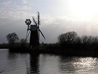
Berney Arms Windmill is a tower mill located at Berney Arms alongside the River Yare at the south-western end of Breydon Water in the English county of Norfolk. The windmill is in an isolated spot in The Broads around 3.5 miles (5.6 km) north-east of the village of Reedham and 4 miles (6.4 km) south-west of Great Yarmouth. The mill has no road access but can be accessed by boat, by foot or from Berney Arms railway station. It is a scheduled monument under the care of English Heritage.

Hunsett Mill is located on the east bank of the River Ant one mile north of Barton Broad in the English county of Norfolk. The Windmill is 1.2 miles south west of the town of Stalham. The mill structure is a grade II listed building.

Boardman's Drainage Windmill is located at How Hill in the English county of Norfolk It is on the east bank of the River Ant close to the large Edwardian building houses the Norfolk Broads Study Centre. The Drainage mill is 1+1⁄2 miles (2.4 km) west of the village of Ludham. The structure is a grade II* listed building.
Clayrack Drainage Windmill is located at How Hill in the English county of Norfolk. It is on the east bank of the River Ant close to How Hill, a large Edwardian building which houses the Norfolk Broads Study Centre. The Drainage mill is 1¾ miles west of the village of Ludham.
Thrigby Post Windmill is located in the civil parish of Mautby in the English county of Norfolk. The mill is on the south side of Mill Lane 1,125 yards (1.029 km) east of the village of Thrigby. The post mill is north of The River Bure, Breydon Water and the Halvergate Marshes.
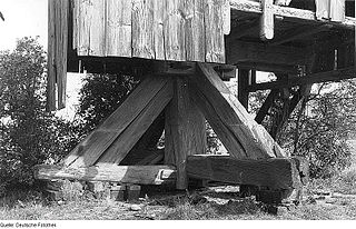
The trestle of a post mill is the arrangement of the main post, crosstrees and quarterbars that form the substructure of this type of windmill. It may or may not be surrounded by a roundhouse. Post mills without a roundhouse are known as open trestle post mills.

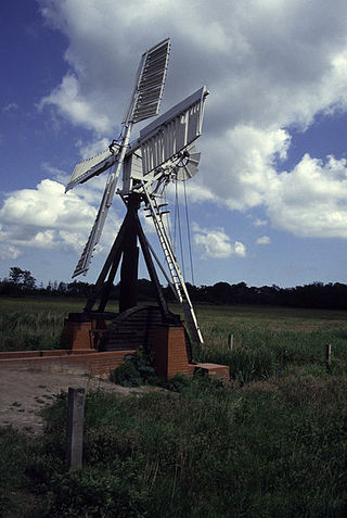
Stubb Drainage Windmill is 1.9 miles east of Hickling in the English county of Norfolk. The Windmill is a Grade II listed building and was given this status on 30 September 1987. The estimate is that there were once about 200 drainage windmills in the Broadlands. Stubb Drainage Windmill is listed as one that is at risk of decay by Norfolk County Council.
The River Till is a river in the county of Lincolnshire in England and is ultimately a tributary of the River Witham. Its upper reaches drain the land east of Gainsborough. The middle section is embanked, as the water level is higher than that of the surrounding land, and pumping stations pump water from low level drainage ditches into the river. Its lower reaches from the hamlet of Odder near Saxilby into the city of Lincoln were canalised, possibly as early as Roman times, as part of the Foss Dyke.

