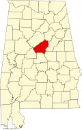
Pea Ridge, Shelby County, Alabama

Last updated

Pea Ridge, Alabama
USA Alabama location map.svg
Red pog.svg
Pea Ridge, Alabama
Usa edcp location map.svg
Red pog.svg
Pea Ridge, Alabama
Coordinates: 33°09′11″N86°55′40″W / 33.15306°N 86.92778°W / 33.15306; -86.92778
Country United States
State Alabama
County Shelby
Area
[1]
  Total15.69 sq mi (40.64 km2)
  Land15.64 sq mi (40.52 km2)
  Water0.05 sq mi (0.12 km2)
Elevation
830 ft (250 m)
Population
 (2020)
  Total841
  Density53.76/sq mi (20.76/km2)
Time zone UTC-6 (Central (CST))
  Summer (DST) UTC-5 (CDT)
Area code(s) 205, 659
GNIS feature ID1989120 [2]

Pea Ridge is a census-designated place in Shelby County, Alabama, United States. The community is named for Pea Ridge, the broadest ridge in the Cahaba Coal Field. This ridge divides the waters of the Cahaba River and Little Cahaba River. [3] Pea Ridge has maintained a volunteer fire department since 1972. [4]

Contents

It was first named as a CDP in the 2020 Census which listed a population of 841. [5]

Demographics

Historical population
CensusPop.Note
2020 841
U.S. Decennial Census [6]
2020 [7]

2020 census

Pea Ridge CDP, Alabama - Demographic Profile
(NH = Non-Hispanic)
Race / EthnicityPop 2020 [7] % 2020
White alone (NH)72185.73%
Black or African American alone (NH)91.07%
Native American or Alaska Native alone (NH)00.00%
Asian alone (NH)00.00%
Pacific Islander alone (NH)00.00%
Some Other Race alone (NH)20.24%
Mixed Race/Multi-Racial (NH)475.59%
Hispanic or Latino (any race)627.37%
Total841100.00%

Note: the US Census treats Hispanic/Latino as an ethnic category. This table excludes Latinos from the racial categories and assigns them to a separate category. Hispanics/Latinos can be of any race.

Related Research Articles

<span class="mw-page-title-main">Bibb County, Alabama</span> County in Alabama, United States

Bibb County is a county in the central portion of the U.S. state of Alabama. The county is included in the ARC's definition of Appalachia. As of the 24th decennial 2020 census, its population was 22,293. The county seat is Centreville. The county is named in honor of William W. Bibb (1781–1820), the Governor of Alabama Territory (1817–1819) and the first Governor of Alabama. He is also the namesake for Bibb County, Georgia, where he began his political career. It is a "prohibition" or dry county; however, a few towns have become "wet" by allowing the sale of alcoholic beverages: Woodstock, West Blocton, Centreville, and Brent. The Bibb County Courthouse is located in the county seat of Centreville.

<span class="mw-page-title-main">Bullock County, Alabama</span> County in Alabama, United States

Bullock County is a county of the U.S. state of Alabama. As of the 2020 census, the population was 10,357. Union Springs was chosen as the county seat in 1867, and presently is the county's only incorporated city. The county was named for Confederate Army Colonel Edward C. Bullock who was a state senator and outspoken secessionist who died during the American Civil War.

<span class="mw-page-title-main">Shelby County, Alabama</span> County in Alabama, United States

Shelby County is located in the central portion of the U.S. state of Alabama. As of the 2020 census the population was 223,024, making it the sixth-most populous county in Alabama. The county seat is Columbiana. Its largest city is Alabaster. The county is named in honor of Isaac Shelby, Governor of Kentucky from 1792 to 1796 and again from 1812 to 1816. Shelby County is included in the Birmingham–Hoover, AL Metropolitan Statistical Area.

<span class="mw-page-title-main">Alabaster, Alabama</span> City in Alabama, United States

Alabaster is a city and southern suburb of Birmingham in Shelby County, Alabama, United States. At the 2020 census, the population was 33,284. Alabaster is the 16th largest city in Alabama by number of residents.

<span class="mw-page-title-main">Georgetown, Quitman County, Georgia</span> City in Georgia, United States

Georgetown is a city in Quitman County, Georgia, United States. It is on the Alabama-Georgia state line next to Walter F. George Lake and across the Chattahoochee River from Eufaula, Alabama. Per the 2020 census, the population was 2,235. In 2006, Georgetown and Quitman County voted to consolidate their governments, becoming the smallest such consolidated entity in the Lower 48 states.

<span class="mw-page-title-main">Blue Ridge, Virginia</span> Census-designated place in Virginia, United States

Blue Ridge is a census-designated place (CDP) in southern Botetourt County, Virginia, United States. The population was 3,185 at the 2020 census. The CDP is located along U.S. Route 460. It is part of the Roanoke Metropolitan Statistical Area.

<span class="mw-page-title-main">Tasley, Virginia</span> Census-designated place in Virginia, United States

Tasley is a census-designated place (CDP) in Accomack County, Virginia, United States. It was first listed as a CDP in 2010. Per the 2020 census, the population was 222.

<span class="mw-page-title-main">Bucks, Alabama</span> Census-designated place in Alabama, United States

Bucks is an unincorporated community and census-designated place (CDP) in Mobile County, Alabama, United States. As of the 2020 census, its population was 22, down from 32 at the 2010 census. It is located in the northeastern section of the county near the Mobile River, along U.S. Route 43. The James M. Barry Electric Generating Plant, a coal- and natural gas-fired power station operated by Alabama Power, is located in Bucks.

<span class="mw-page-title-main">Equality, Alabama</span> Census-designated place in Alabama, United States

Equality is a census-designated place in Coosa County, Alabama, United States. It was first named as a CDP in the 2020 Census which listed a population of 150. The Equality post office serves the ZIP Code of 36026, and its delivery area includes rural land to the south in Elmore County.

<span class="mw-page-title-main">Lewistown, Maryland</span> Census-designated place in Maryland

Lewistown is a census designated place and unincorporated community in Frederick County, Maryland, United States. Lewistown Elementary school, part of Frederick County Public Schools, is located in Lewistown. The town, founded in 1841, has had a school since the 19th century. There is a large elderly population in the community. It first appeared as a CDP in the 2020 Census with a population of 458.

<span class="mw-page-title-main">Calvert, Alabama</span> Census-designated place in Alabama, United States

Calvert is an unincorporated community and census-designated place (CDP) in Mobile and Washington counties, Alabama, United States. It is located in the extreme northeast corner of Mobile County and southeast corner of Washington County near the Tombigbee River, along U.S. Route 43. As of the 2020 census, the population of Calvert was 255.

<span class="mw-page-title-main">Holiday Island, Arkansas</span> City in Arkansas, United States

Holiday Island is a 4,500-acre planned retirement and vacation community in Carroll County, Arkansas, United States. Formerly an unincorporated community and census-designated place (CDP), it voted to incorporate in November 2020. As of the 2020 census, the population was 2,533. Holiday Island is located in the Ozark Mountains on Table Rock Lake, near Eureka Springs, Arkansas and only an hour from Branson, Missouri, Fayetteville, Arkansas, and Bentonville, Arkansas. Community growth has been fueled by the expansion of the corporate giants headquartered in Northwest Arkansas, the entertainment attractions in Eureka Springs and Branson, the visitor traffic from the Crystal Bridges Museum of American Art, Pea Ridge National Military Park, and Roaring River State Park, and the influence of the state's largest University, the University of Arkansas.

Mount Pleasant is a census-designated place and unincorporated community in Marshall County, Mississippi, United States, located along U.S. Highway 72 at State Highway 311. The community has a volunteer fire department on Boswell Road, and a K-12 school located off Highway 72.

Leaf is a census-designated place and unincorporated community in Greene County, Mississippi, United States.

<span class="mw-page-title-main">Stewart, Mississippi</span> Census-designated place in Mississippi, United States

Stewart is a census-designated place and unincorporated community in Montgomery County, Mississippi, United States. As of the 2020 census, it had a population of 99.

Remlap is a census-designated place in Blount County, Alabama, United States, located along Alabama State Route 75, 11.7 miles (18.8 km) southwest of Oneonta. Remlap has a post office with ZIP code 35133.

Hanover is a census-designated place in Coosa County, Alabama, United States.

Eagle Point is a census-designated place in Shelby County, Alabama, United States. It was first listed as a CDP prior to the 2020 census and is part of the Birmingham Metropolitan Area. The area was struck by a long-tracked low-end EF3 tornado on March 25, 2021, damaging or destroying several homes and downing trees. Five people were injured by the tornado.

Pine Ridge is an unincorporated community and census-designated place (CDP) in Darlington County, South Carolina, United States. It was first listed as a CDP prior to the 2020 census with a population of 807.

Whitney is an unincorporated area and census-designated place (CDP) adjacent to the city of Spartanburg in Spartanburg County, South Carolina, United States. It was first listed as a CDP prior to the 2020 census with a population of 4,409.

References

  1. "2020 U.S. Gazetteer Files". United States Census Bureau. Retrieved October 29, 2021.
  2. "Pea Ridge". Geographic Names Information System . United States Geological Survey, United States Department of the Interior.
  3. Report on the Cahaba coal field - Joseph Squire, Eugene Allen Smith. Brown Printing Company. 1890. p.  8 . Retrieved May 31, 2014 via Internet Archive. pea ridge shelby county alabama.
  4. Catherine Legg (February 28, 2012). "Pea Ridge celebrates its volunteer fire department". Shelby County Reporter. Retrieved May 31, 2014.
  5. "Pea Ridge CDP, Alabama". United States Census Bureau . Retrieved March 13, 2022.
  6. "Decennial Census of Population and Housing by Decades". US Census Bureau.
  7. 1 2 "P2 HISPANIC OR LATINO, AND NOT HISPANIC OR LATINO BY RACE - 2020: DEC Redistricting Data (PL 94-171) - Pea Ridge CDP, Alabama". United States Census Bureau .