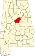
Acton, Alabama

Last updated

Acton, Alabama
USA Alabama location map.svg
Red pog.svg
Acton, Alabama
Usa edcp location map.svg
Red pog.svg
Acton, Alabama
Coordinates: 33°21′22″N86°48′25″W / 33.35611°N 86.80694°W / 33.35611; -86.80694
Country United States
State Alabama
County Shelby
Elevation
[1]
505 ft (154 m)
Time zone UTC-6 (Central (CST))
  Summer (DST) UTC-5 (CDT)
Zip Code
35244
Area codes 205, 659
GNIS feature ID112906 [1]

Acton is an unincorporated community in Shelby County, in the U.S. state of Alabama. [1] It is partially located within the city of Hoover. It is not to be confused with the village of Acton, approximately 6+12 miles to the northeast in Jefferson County.

Contents

History

Alabama Fuel & Iron Company established coal mines at Acton and the company town of Acton grew up around them. The mines were served by the Louisville and Nashville Railroad. On November 18, 1913, 21 miners were killed by an explosion in Mine Number 2. [2] After the mines closed, the area was converted into the Riverchase real estate development. [3]

A post office was established at Acton in 1908, and remained in operation until it was discontinued in 1926. [4] The community was likely named for William Acton, a local businessperson in the mining industry. [5]

In the 1970s, the land was developed into the Riverchase residential planned community, which was annexed into Hoover, Alabama in 1980.

Demographics

Acton/Highland Precinct (1870-1950)

Historical population
CensusPop.Note
1870 657
1880 494−24.8%
1890 484−2.0%
1900 444−8.3%
1910 1,282188.7%
1920 1,076−16.1%
1930 746−30.7%
1940 83411.8%
1950 97416.8%
U.S. Decennial Census [6]

According to the census returns from 1850 [7] -2010 [8] for Alabama, Acton village has never reported a population figure separately on the U.S. Census. Acton (Precinct 12 of Shelby County) first appeared on the 1920 U.S. Census [9] (not to be confused with Acton's Precinct 15, which appeared in 1880 and was moved to Jefferson County, where the other Acton village is located). Acton Precinct only appeared under this name on this one occasion. Prior to 1920 and again from 1930 to 1950 the name was Highland Precinct, which first appeared on the 1870 census as Shelby County Beat 4 [10] and then Beat/Precinct 12 from 1880-onwards. [11] In 1960, the precincts were merged and/or reorganized into census divisions (as part of a general reorganization of counties) and it was consolidated into the census division of Helena. [12] In 1980, that census division was consolidated into the new division of Alabaster-Helena. [13]

Related Research Articles

<span class="mw-page-title-main">Shelby County, Alabama</span> County in Alabama, United States

Shelby County is located in the central portion of the U.S. state of Alabama. As of the 2020 census the population was 223,024, making it the sixth-most populous county in Alabama. The county seat is Columbiana. Its largest city is Alabaster. The county is named in honor of Isaac Shelby, Governor of Kentucky from 1792 to 1796 and again from 1812 to 1816. Shelby County is included in the Birmingham–Hoover, AL Metropolitan Statistical Area.

<span class="mw-page-title-main">Andalusia, Alabama</span> City in and county seat of Covington County, Alabama

Andalusia is a city in and the county seat of Covington County, Alabama, United States. At the 2020 census, the population was 8,805.

<span class="mw-page-title-main">Helena, Alabama</span> City in Alabama, United States

Helena is a city in Jefferson and Shelby counties in the state of Alabama. Helena is considered a suburb of Birmingham and part of the Birmingham-Hoover Metropolitan Area. As of 2022 the United States Census Bureau estimates the population to be 21,862.

<span class="mw-page-title-main">Hoover, Alabama</span> City in Alabama, United States

Hoover is a city in the Jefferson and Shelby counties in north central Alabama, United States. Hoover is the largest suburban city in Alabama and the 6th largest city in Alabama. The population was 92,606 at the 2020 census. Hoover is part of the Birmingham, AL Metropolitan Statistical Area and is also included in the Birmingham-Cullman-Talladega, AL Combined Statistical Area. Hoover's territory is along the foothills of the Appalachian Mountains.

<span class="mw-page-title-main">Mulga, Alabama</span> Town in Alabama, United States

Mulga is a town in western Jefferson County, Alabama, United States. It is north from the Birmingham suburb of Pleasant Grove. It includes the community of Bayview. Mulga was a company town operated by Birmingham Coal and Iron Company around the Mulga Mine and Mulga was also the name of an independent community in the area. The company town was incorporated in 1947.

<span class="mw-page-title-main">Alabaster, Alabama</span> City in Alabama, United States

Alabaster is a city and southern suburb of Birmingham in Shelby County, Alabama, United States. At the 2020 census, the population was 33,284. Alabaster is the 16th largest city in Alabama by number of residents.

<span class="mw-page-title-main">Interstate 459</span> Highway in Alabama

Interstate 459 (I-459) is a bypass highway of I-59 that is an alternate Interstate Highway around the southern sides of Birmingham, Bessemer, and several other cities and towns in Jefferson County, Alabama. I-459 lies entirely within Jefferson County. This Interstate Highway is about 32.8 miles (52.8 km) long, and its construction was completed in 1984. I-459 has major interchanges with I-59, I-20, and I-65.

The Birmingham District is a geological area in the vicinity of Birmingham, Alabama, where the raw materials for making steel, limestone, iron ore, and coal are found together in abundance. The district includes Red Mountain, Jones Valley, and the Warrior and Cahaba coal fields in Central Alabama.

<span class="mw-page-title-main">Ackerville, Alabama</span> Unincorporated community in Alabama, United States

Ackerville is an unincorporated community in Wilcox County, Alabama, United States. Ackerville has one site included on the National Register of Historic Places, the Ackerville Baptist Church of Christ.

<span class="mw-page-title-main">Birmingham metropolitan area, Alabama</span> Metropolitan area in Alabama, United States

The Birmingham metropolitan area, sometimes known as Greater Birmingham, is a metropolitan area in north central Alabama centered on Birmingham, Alabama, United States.

Aldrich is an unincorporated community in Shelby County, Alabama, United States, that is now part of Montevallo.

<span class="mw-page-title-main">Arbacoochee, Alabama</span> Unincorporated community in Alabama, United States

Arbacoochee is an unincorporated community in Cleburne County, Alabama, United States.

Coalburg is an unincorporated community in Jefferson County, Alabama, United States.

Almond, also known as Flat Rock, is an unincorporated community in Randolph County, Alabama, United States.

Acmar is a former unincorporated community and neighborhood within the city of Moody in St. Clair County, in the U.S. state of Alabama.

Henry Fairchild DeBardeleben was an American coal magnate and town founder from Alabama.

<span class="mw-page-title-main">Marvel, Alabama</span> Unincorporated community in Alabama, United States

Marvel is an unincorporated community in Bibb County, Alabama, United States.

<span class="mw-page-title-main">Allenton, Alabama</span> Unincorporated community in Alabama, United States

Allenton is an unincorporated community in Wilcox County, Alabama, United States.

Acton is an unincorporated community in Jefferson County, in the U.S. state of Alabama. It is a suburban area bordering the city of Birmingham, centered around the intersection of Caldwell Mill Road and Old Looney Mill Road just west of the Cahaba River. It is not to be confused with the former mining village of Acton, Alabama in Shelby County (now within the city of Hoover, approximately 6+12 miles to the southwest as the crow flies. Initially, this Acton was also in Shelby County before a border adjustment shifted it into Jefferson County.

Bradford, also known as Dixiana, is an unincorporated community in Jefferson County, Alabama, United States.

References

  1. 1 2 3 "Acton". Geographic Names Information System . United States Geological Survey, United States Department of the Interior.
  2. "Explosion Kills Miners", New York Times, November 19, 1913
  3. James Sanders Day (June 24, 2013). Diamonds in the Rough: A History of Alabama's Cahaba Coal Field. University of Alabama Press. pp. 83–206. ISBN   978-0-8173-1794-2.
  4. "Shelby County". Jim Forte Postal History. Retrieved February 9, 2015.
  5. Foscue, Virginia O. (1989). Place Names in Alabama. University of Alabama Press. p. 6. ISBN   978-0-8173-0410-2.
  6. "U.S. Decennial Census". Census.gov. Retrieved June 6, 2013.
  7. 1850 Census (places) [ permanent dead link ]
  8. 2010 AL Census
  9. 1920 AL Census
  10. 1870 AL Census
  11. 1880 AL Census
  12. 1960 AL Census [ permanent dead link ]
  13. 1980 AL Census