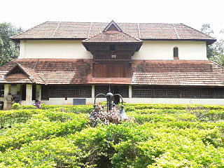
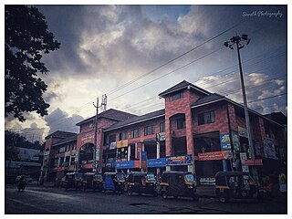
Nedumangad is a town and municipality in Thiruvananthapuram metropolitan area of Thiruvananthapuram district in the Indian state of Kerala, and is the headquarters of Nedumangad tehsil and Nedumangad Revenue Division (RDO). It is a suburb of the extended metropolitan region of Thiruvananthapuram city. It is located around 16 km to the north-east of Thiruvananthapuram city on the Thiruvananthapuram – Shenkottah (State Highway 2). It is an important commercial center in the district. It is a growing commercial and educational hub and all important government institutions are situated in the town. Nedumangadu Market is important in South Kerala.

Ponmudi also known as Kashmir of Kerala is a hill station in the Peringamala gramapanchayath of Trivandrum District of Kerala in India. It is located 22km west of Vithura town, 53 km north-east of Trivandrum City, 78 km south-east of Varkala town and 69 km north-east of Kovalam Beach at an altitude of 1,100 m (3,600 ft). Ponmudi (Varayadumotta) peak is a part of the Western Ghats mountain range that runs parallel to the Arabian Sea. Ponmudi is a popular honeymoon destination in South India. The normal temperature of Ponmudi is between 18 and 25 °C.
Nemom is an area in the city of Thiruvananthapuram. It is surrounded by Thirumala in the north, Malayinkeezhu in the north-east, Balaramapuram in the south-east, Kovalam in the south and Thiruvallam in the west. Nemom falls within the municipal corporation of Thiruvananthapuram, though partly exclusive. It is connected with Thiruvananthapuram, Neyyattinkara, Vizhinjam, Poovar, Kattakkada, Nagarcoil, and Kanyakumari through the main arterial highway National Highway 66.
Aryanadu is a village town in Thiruvananthapuram district, Kerala, India, lying under the foothills of the Agastyarkoodam of the Sahya mountains. The village is spread along the sides of Karamana River in the western ghats of Agasthya Mountains. The Aryanad Panchayath has border with Uzhamalakkal, Vellanad, Poovachal, Kuttichal, Vithura, Tholickode panchayaths. Aryanad is residing Nedumangad Taluk and Aruvikkara Legislative Assembly. It is situated around 25 km from Thiruvananthapuram. G. Steephen is the current sitting MLA of Aryanad.
Pangode is an Indian village and a Grama Panchayat located in the Trivandrum district in the state of Kerala. The village is known for its participation in the Indian Independence Movement, through the Kallara-Pangode Struggle. It is situated in the foothills of Western Ghats.
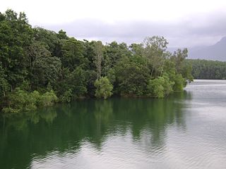
The Peppara Wildlife Sanctuary is a wildlife sanctuary in Thiruvananthapuram district of Kerala, India. It consists of the catchment area of the Karamana River, which originates from Chemmunjimottai, the tallest hill within the sanctuary. The sanctuary is named after the Peppara Dam, commissioned in 1983 to augment the drinking water supply to Thiruvananthapuram city and suburban areas. Considering the ecological significance of the area, it was declared a sanctuary in 1983. The terrain is undulating with elevation ranging from 100 m to 1717 m. The area of the sanctuary is 75 km2 with tropical moist evergreen forests and myristica swamps. It is part of the Agasthyamala Biosphere Reserve. Peppara Wildlife Sanctuary is 44 kilometres (27 mi) by car from the nearest railway station, at Thiruvananthapuram, and 49 kilometres (30 mi) from the Thiruvananthapuram airport.
Kattakada is a town in Thiruvananthapuram district of Kerala. It is situated 13km north of Neyyattinkara town, 18km south of Nedumangad town and 20km east of Capital City Thiruvananthapuram.
Karakulam is a panchayat in Nedumangad Taluk in Tiruvananthapuram District in the state of Kerala, India. It is the most populated panchayat in the district according to 2011 census.

Palode is a town in Thiruvananthapuram district in the Indian state of Kerala. Palode town is 35 km (22 mi) from Thiruvananthapuram city and 17 km (11 mi) from Nedumangad municipality.There is a Helipad in palode. Palode is surrounded by Western Ghats. Jawaharlal Nehru Tropical Botanic Garden and Research Institute is situated near Palode. Mankayam Ecotourism near Brimore is 11 km (6.8 mi) away. Brimore has tea estate and plantations make Palode a gateway for tourism destination.Thenmala is 38 km (24 mi) from Palode and Ponmudi hills is 35 km. Palode is town in Thiruvananthapuram-Thenmala -Shenkottai State Highway 2 (Kerala). Tenkasi is 75 km (47 mi) from Palode. Palode is a town located in Nedumangad Taluk of Thiruvananthapuram district in Kerala.
Peringamala is a grama panchayat in Thiruvananthapuram district in the state of Kerala, India. There are two places named Peringammala, the other one is between Balaramapuram and Venganoor which is on the southern side of the Thiruvananthapuram district.There is two villages Peringammala and Thennoor.
Vembayam is a village in Thiruvananthapuram district in the state of Kerala, India.
Venjaramoodu is a north-east suburb of Trivandrum city, the capital of Kerala. It is 9 km (5.6 mi) east of Attingal, 11 km (6.8 mi) northwest of Nedumangad, 12 km (7.5 mi) northeast of Trivandrum City and 26 km (16 mi) south-east of Varkala.
State Highway 2 is a State Highway in Kerala, India that starts from Thiruvananthapuram Peroorkada and ends near Thenmala Kollam by joining with Kollam-Tirumangalam NH-744. The highway is 73.2 km long. The major towns in this highway are Nedumangad, Palode and Kulathupuzha. It is a major inter state highway road connecting Thiruvananthapuram the Capital City of Kerala to Shenkottai and Madurai in Tamil Nadu. In 2016 NHAI approved in principle this road as National highway.
Nedumangad Taluk is a Taluk (tehsil) in Thiruvananthapuram district in the Indian state of Kerala. It situated in the eastern part of the Thiruvananthapuram district. It comprises 23 villages and one municipality.

The Indian city of Thiruvananthapuram is located in Thiruvananthapuram district in the state of Kerala. The city is located at 8.5°N 76.9°E on the west coast, near the southern tip of mainland India. The city situated on the west coast of India, and is bounded by Arabian Sea to its west and the Western Ghats to its east. The city and the suburbs spans an area of 250 km2 (96.53 sq mi). The average elevation of the city is 16 ft above sea level. The highest point within the city limits is the observatory. Agastya Mala, which has an elevation of 1,868 metres (6,129 ft) is only about 60 km from the city. The Ponmudi hill station which has an elevation of 1,100 metres (3,609 ft) is also near the city.
Vembannur is a village located in the Nedumangad taluk of the Thiruvananthapuram District in Kerala, India. Vembannur comes under the Aruvikkara panchayat of the Nedumangad Taluk.
Vazhayila is an prime city near Peroorkada. Located at Trivandrum District. The exact location is 2 to 3 kilometers from the kowdiar Palace. It comes under Vattiyoorkavu constituency. Vazhayila has 4-lane road, Petrol pumps, Car showroom, Sports club, Corporation water facility, High speed internet, Online Taxi and food services etc.. There are various shopping centers, Many Flat and villa Projects in it.
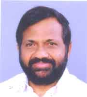
Palode Ravi (born 25 July 1949) is an Indian politician and is the DCC President of Thiruvananthapuram. He has served as the Deputy speaker and member of the Kerala Legislative Assembly, from the Nedumangad constituency, representing the Indian National Congress.
Meenankal is a village in Thiruvananthapuram district in the state of Kerala, India, and located around 5 kilometers away from the Peppara Wildlife Sanctuary. Meenankal has border with Uzhamalakkal, Vellanad, Anad, Kuttichal, Vithura, Tholickode panchayaths and Thiruneveli District of Tamil Nadu, India. It's located in the Nedumangad Taluk and Aruvikkara Legislative Assembly. It is situated around 35 km away from Thiruvananthapuram city.

Varayadumotta is the tallest peak in the Ponmudi mountain range, Nedumangad taluk, Thiruvananthapuram, Kerala, India. As its name come from Nilgiri tahr / Varayadu. It is one of the isolated place which is favourable home for mountain goats in acute population. These mountain range is also known as Varayadumudi and Varayattumutti.
