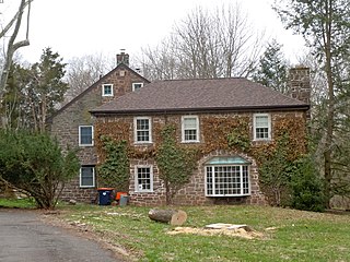
Collegeville is a borough in Montgomery County, Pennsylvania, a suburb outside of Philadelphia on Perkiomen Creek. Collegeville was incorporated in 1896. It is the location of Ursinus College, which opened in 1869. The population was 5,089 at the 2010 census.

Upper Providence Township is a township in Montgomery County, Pennsylvania, United States. As of the 2010 census, the township population was 21,219.

The Allegheny Portage Railroad was the first railroad constructed through the Allegheny Mountains in central Pennsylvania. It operated from 1834 to 1854 as the first transportation infrastructure through the gaps of the Allegheny that connected the midwest to the eastern seaboard across the barrier range of the Allegheny Front. Approximately 36 miles (58 km) long overall, both ends connected to the Pennsylvania Canal, and the system was primarily used as a portage railway, hauling river boats and barges over the divide between the Ohio and the Susquehanna Rivers. Today, the remains of the railroad are preserved within the Allegheny Portage Railroad National Historic Site operated by the National Park Service.

U.S. Route 422 (US 422) is a 271-mile-long (436 km) spur route of US 22 split into two segments in the U.S. states of Ohio and Pennsylvania. The western segment of US 422 runs from downtown Cleveland, Ohio, east to Ebensburg, Pennsylvania. The eastern segment, located entirely within Pennsylvania, runs from Hershey east to King of Prussia, near Philadelphia. US 422 Business serves as a business route into each of four towns along the way.

Pennsylvania Route 29 is a 118-mile-long (190 km) north–south state highway that runs through most of eastern Pennsylvania.

The Frankford Avenue Bridge, also known as the Pennypack Creek Bridge, the Pennypack Bridge, the Holmesburg Bridge, and the King's Highway Bridge, erected in 1697 in the Holmesburg section of Northeast Philadelphia, in the U.S. state of Pennsylvania, is the oldest surviving roadway bridge in the United States. The three-span, 73-foot-long (22 m) twin stone arch bridge carries Frankford Avenue, just north of Solly Avenue, over Pennypack Creek in Pennypack Park.

Pennsylvania Route 73 (PA 73) is a 62.32-mile (100.29 km) long east–west state highway in southeastern Pennsylvania. It runs from PA 61 near Leesport southeast to the New Jersey state line on the Tacony–Palmyra Bridge over the Delaware River in Philadelphia, where the road continues south as New Jersey Route 73. The route passes through rural areas of Berks County, crossing U.S. Route 222 (US 222) in Maiden Creek before heading southeast through Oley and Boyertown. PA 73 continues into Montgomery County and intersects PA 100 in Gilbertsville and PA 29 in Schwenksville before it heads into the northwest suburbs of Philadelphia. The route passes through Skippack and intersects US 202 in Center Square, PA 309 in Springfield Township, and PA 611 near Jenkintown. PA 73 continues through Northeast Philadelphia on Cottman Avenue, crossing US 1 and US 13 before coming to an interchange with Interstate 95 (I-95) near the Tacony–Palmyra Bridge.
The Albertus L. Meyers Bridge, also known as the Eighth Street Bridge, the South Eighth Street Viaduct, and unsigned as SR 2055, is a reinforced concrete open-spandrel arch bridge located in Allentown, Pennsylvania. The bridge is "one of the earliest surviving examples of monumental, reinforced concrete construction," according to the American Society of Civil Engineers.

The Cogan House Covered Bridge is a Burr arch truss covered bridge over Larrys Creek in Cogan House Township, Lycoming County, in the U.S. state of Pennsylvania. It was built in 1877 and is 94 feet 2 inches (28.7 m) long. The bridge was placed on the National Register of Historic Places in 1980, and had a major restoration in 1998. The Cogan House bridge is named for the township and village of Cogan House, and is also known by at least four other names: Buckhorn, Larrys Creek, Day's, and Plankenhorn.

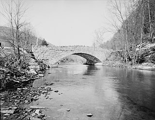
Dunlap's Creek Bridge was the first arch bridge in the United States built of cast iron. It was designed by Richard Delafield and built by the United States Army Corps of Engineers. Constructed from 1836 to 1839 on the National Road in Brownsville, Pennsylvania, it remains in use today. It is listed on the National Register of Historic Places and is a National Historic Civil Engineering Landmark (1978). It is located in the Brownsville Commercial Historic District and supports Market Street, the local main thoroughfare. Due to the steep sides of the Monongahela River valley, there is only room for two short streets parallel to the river's shore and graded mild enough to be comfortable to walk before the terrain rises too steeply for business traffic.

The Hares Hill Road Bridge is a single-span, wrought iron, bowstring-shaped lattice girder bridge. It was built in 1869 by Moseley Iron Bridge and Roof Company and is the only known surviving example of this kind. The bridge spans French Creek, a Pennsylvania Scenic River.

The Forksville Covered Bridge is a Burr arch truss covered bridge over Loyalsock Creek in the borough of Forksville, Sullivan County, in the U.S. state of Pennsylvania. It was built in 1850 and is 152 feet 11 inches (46.61 m) in length. The bridge was placed on the National Register of Historic Places in 1980. The Forksville bridge is named for the borough it is in, which in turn is named for its location at the confluence or "forks" of the Little Loyalsock and Loyalsock Creeks.

The Coatesville High Bridge is a stone masonry arch railroad viaduct that crosses the valley of the West Branch Brandywine Creek at Coatesville, Pennsylvania. Built by the Pennsylvania Railroad between 1902 and 1904, it has ten arches and spans a total length of 934 feet (285 m), with wing walls extending it to 1,287 feet (392 m). 78 feet (24 m) high, the bridge was built to accommodate four standard gauge railroad tracks, with a total length of 52 feet (16 m).
Plunketts Creek Bridge No. 3 was a rubble masonry stone arch bridge over Plunketts Creek in Plunketts Creek Township, Lycoming County in the U.S. state of Pennsylvania. It was built between 1840 and 1875, probably closer to 1840, when the road along the creek between the unincorporated villages of Barbours and Proctor was constructed. Going upstream from the mouth, the bridge was the third to cross the creek, hence its name.

The Bridge between Monroe and Penn Townships, also known as the Penns Creek Bridge, Camelback Bridge, or Camelback, was a historic bridge located at Monroe Township and Penn Township near Selinsgrove in Snyder County, Pennsylvania. It was a 194-foot-long (59 m) barrel arch bridge built in 1919. It spanned Penns Creek. It was removed in 1994.

The Pithole Stone Arch Bridge is a 37-foot (11 m) masonry, deck arch bridge that spans Pithole Creek between Cornplanter and President Townships, Venango County in the U.S. state of Pennsylvania. The bridge was listed on the National Register of Historic Places in 1988 and was documented by the Historic American Engineering Record (HAER) in 1997.

The Skew Arch Bridge in Reading, Pennsylvania, also known as the Askew Bridge and nicknamed the Soap and Whiskey Bridge, is an historic skew arch bridge that was completed in 1857. Its design enabled it to carry two tracks of the Philadelphia and Reading Railroad (P&R) at an angle over Sixth Street in Reading, Berks County, Pennsylvania.
Ridge Pike is a major historic road in the U.S. state of Pennsylvania that opened in 1706 that originally connected Wissahickon Creek to Perkiomen Creek. Inside Philadelphia, it is called Ridge Avenue. Going westward, it traverses many eastern Pennsylvania neighborhoods in Montgomery County including Conshohocken and beyond, connecting with Germantown Pike near Collegeville and continuing to Pottstown. In Montgomery County, Ridge Pike is called Main Street in the Norristown area and again in Collegeville and Trappe, and is called High Street in the Pottstown area.
Germantown Pike is a historic road in Pennsylvania that opened in 1687, running from Philadelphia northwest to Collegeville. The road is particularly notable for the "imposing mansions" that existed in the Germantown neighborhood in Philadelphia. The road was left in ruins after the British destroyed it in the Revolutionary War during the 1777 Battle of Germantown, and was not rebuilt until 1809. Portions of Germantown Pike were signed as U.S. Route 422 (US 422) before the latter was rerouted along a freeway alignment to King of Prussia.
The Penn Street Bridge, also known as the Penn Street Viaduct, is a historic bridge crossing the Schuylkill River into Reading, Pennsylvania, the largest city in Berks County and fourth-largest city in the state. The bridge is considered to be the primary gateway to downtown Reading, leading directly onto Penn Street, the main thoroughfare of the city. The opposite end of the bridge leads into the borough of West Reading and connects with an interchange onto the West Shore Bypass section of U.S. Route 422. As a result of the bridge's prominent location, it has an average daily traffic volume of nearly 34,000. Constructed in 1913, the bridge is one of the oldest examples in the region of an open-spandrel concrete arch bridge, and it retains good historic integrity including original ornate concrete railings; it was determined eligible for listing in the National Register of Historic Places in 2007 and reevaluated in 2019.


