Related Research Articles

Botetourt County is a United States county that lies in the Roanoke Region of the Commonwealth of Virginia. Located in the mountainous portion of the state, the county is bordered by two major ranges, the Blue Ridge Mountains and the Appalachian Mountains.

Watership Down is a hill, or down, at Ecchinswell in the civil parish of Ecchinswell, Sydmonton and Bishops Green in the English county of Hampshire, as part of the Hampshire Downs. It rises fairly steeply on its northern flank, but to the south the slope is much gentler.
Rocky Mountain is a peak of the Blue Ridge Mountains in Virginia. It is located about 2 miles (3.5 km) east of Irish Gap, on the border of Rockbridge County and Amherst County; it is the highest point of both counties. Rocky Mountain is flanked to the northeast by Elk Pond Mountain, to the southwest by Grapevine Ridge, and to the south by Tar Jacket Ridge.
Lowesville is an unincorporated community in Nelson County, Virginia, United States. It lies along the path of the now-defunct Virginia Blue Ridge Railway.
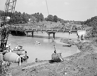
Montebello is an unincorporated community in Nelson County, Virginia, United States. It was among the communities severely affected by flash flooding from Hurricane Camille in 1969.
Piney River is an unincorporated community in Nelson County, Virginia, United States. It lies along the path of the now-defunct Virginia Blue Ridge Railway.

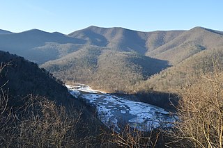
The Tye River is a 35.4-mile-long (57.0 km) tributary of the James River in central Virginia in the United States. Originating on the eastern slope of the Blue Ridge Mountains in Nelson County, and fed by the Piney and Buffalo rivers, by way of the James River it is part of the watershed of the Chesapeake Bay.

Pineridge is an unincorporated community in Fresno County, California. It is located 4 miles (6.4 km) southwest of Shaver Lake Heights, at an elevation of 4842 feet.
Turkeycock Mountain is a mountain summit located in Franklin County, Virginia and Henry County, Virginia. Rising out of the eastern foothills of the Blue Ridge Mountains, Turkeycock Mountain rises to 1,657 feet (505 m) above sea level and is located at 36°49′45″N79°41′13″W. A portion of the mountain is protected as the Turkeycock Wildlife Management Area, which is open to the public.
The Buffalo River is a 31.5-mile-long (50.7 km) tributary of the Tye River in the U.S. state of Virginia. It is part of the James River watershed.

Craig Creek is an 84-mile-long (135 km) tributary of the James River in the U.S. state of Virginia. It flows through the Ridge-and-Valley Appalachians in western Virginia, passing 15 miles (24 km) northwest of Roanoke.
The Saint Marys River is an 8.4-mile-long (13.5 km) tributary of the South River in Augusta County in the U.S. state of Virginia. By the South and Maury rivers, it is part of the James River watershed.
The South River is a 20.3-mile-long (32.7 km) tributary of the Maury River in the U.S. state of Virginia. It is part of the James River watershed.
Caroline Pines is an unincorporated community in Caroline County, in the U.S. state of Virginia.
Brights is an unincorporated community in Pittsylvania County, in the U.S. state of Virginia.
Oak Ridge, Pittsylvania County is an unincorporated community in Pittsylvania County, Virginia. It is known as the location of the holiday home of former British prime minister Gordon Brown.
York River Pines is an unincorporated community in Gloucester County, in the U. S. state of Virginia.
Roanoke Mountain is a mountain in Virginia. It is located two miles south of the Roanoke River and one mile east of the Blue Ridge Parkway.
The James River Gorge is a water gap created by the James River in Central Virginia. The Gorge is 2,433 feet (742 m) deep as measured from Highcock Knob 3,073 feet (937 m) to the James River 640 feet (200 m) and is approximately 9.3 miles (15.0 km) long. The James River forms in western Virginia near the border of West Virginia and initially flows south through the ridge and valley province of the Allegheny Mountains, turning northeast when it comes to the western edge of the Blue Ridge Mountains near Buchanan, Virginia. From Buchanan the river flows along the base of the Blue Ridge Mountains until it joins the Maury River near the town of Glasgow and then it turns southeast and begins its descent over the Balcony Falls rapids and through the James River Gorge. The rocks of the gorge are metamorphic in nature with the oldest exposed outcrops being from the Proterozoic Era. To the south of the river the peaks of the James River Face Wilderness dominate and to the north the peaks of Big Rocky Row and Little Rocky Row Mountains form a dramatic backdrop to the river far below. Multiple trails, including the Appalachian Trail go through the gorge and provide spectacular vistas of the scenery both at river level and from the peaks to the north and the south.

Chestnut Ridge is the westernmost ridge of the Allegheny Mountains in Pennsylvania. It is located primarily within the Laurel Highlands region of southwestern Pennsylvania, extending into northern West Virginia.
References
Coordinates: 37°06′02″N79°17′18″W / 37.10042°N 79.28836°W
| This Pittsylvania County, Virginia state location article is a stub. You can help Wikipedia by expanding it. |