Related Research Articles

Allegheny County is a county in Pennsylvania, United States. It is located in Southwestern Pennsylvania. As of the 2020 census, the population was 1,250,578, making it the state's second-most populous county, after Philadelphia County. Its county seat and most populous city is Pittsburgh, Pennsylvania's second most populous city. Allegheny County is the center of the Pittsburgh, PA metropolitan statistical area and the Pittsburgh media market.

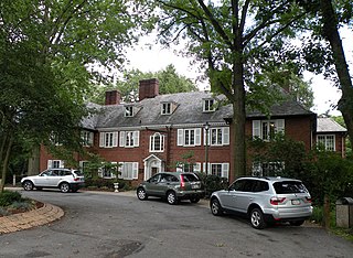
Jefferson Hills is a borough in Allegheny County, Pennsylvania, United States. In the 2020 census, the population was 12,424. It is part of the Pittsburgh metropolitan area.
Moon Township is a township in Allegheny County, Pennsylvania, United States, along the Ohio River. The population was 27,261 at the 2020 census. Located 12 miles (19 km) northwest of Pittsburgh, the township is part of the Pittsburgh metropolitan area and is home to Pittsburgh International Airport.

North Braddock is a borough in Allegheny County, Pennsylvania, United States, along the Monongahela River. The 2020 census had the borough population at 4,320. It is a suburb 11 miles (18 km) east of Pittsburgh. Organized from a part of Braddock Township in 1897, the borough prides itself in being the "Birthplace of Steel" as the home of Andrew Carnegie's Edgar Thomson Steel Works that opened in 1875.

North Versailles is a first class township in Allegheny County, Pennsylvania, United States. The population was 10,079 at the 2020 census. The township derives its name from the Palace of Versailles.

Penn Hills is a township with home rule status in Allegheny County, Pennsylvania, United States. The population was 41,059 as of the 2020 census. A suburb of Pittsburgh, Penn Hills is the second-largest municipality in Allegheny County.

Turtle Creek is a borough in Allegheny County, Pennsylvania, United States, 12 miles (19 km) southeast of Pittsburgh. The population was 5,114 at the 2020 census. George Westinghouse constructed a manufacturing plant nearby. Turtle Creek takes its name from a small stream that flows into the Monongahela River. Before white settlers arrived, there was a small village of Native Americans living there from the Turtle Clan of the Iroquois Nation.
Industry is a borough in western Beaver County, Pennsylvania, United States, along the Ohio River. As of the 2020 census, the population was 1,833. It is part of the Pittsburgh metropolitan area.

Wilkins Township is a township in Allegheny County, Pennsylvania, United States. The population was 6,357 at the 2010 census. It is served by Pennsylvania's 12th congressional district, the 43rd District of the Pennsylvania State Senate, and the 34th District of the Pennsylvania State House of Representatives.

Yohogania County was created by the new state of Virginia in 1776, in an area long disputed between Virginia and Pennsylvania. The county ceased to exist after the border dispute between the two states was resolved in the 1780s. Thus, it is sometimes referred to as a "lost county," although 1.5 million people live within the territory it once claimed, which encompasses two entire counties and parts of four others in two states.

Transportation in Pittsburgh, Pennsylvania is different than in many other major American cities. A large metropolitan area that is surrounded by rivers and hills, Pittsburgh has an infrastructure system that has been built out over the years to include roads, tunnels, bridges, railroads, inclines, bike paths, and stairways; however, the hills and rivers still form many barriers to transportation within the city.
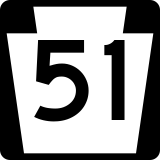
Pennsylvania Route 51 is a major state highway that is located in Western Pennsylvania in the United States. It runs for 89 miles (143 km) from Uniontown to the Ohio state line near Darlington, where it connects with Ohio State Route 14.
St. Clair Township, Allegheny County, Pennsylvania, was one of the original townships created with the incorporation of Allegheny County in 1788. The township was named after Arthur St. Clair, an American Revolutionary War general and president of the Continental Congress in 1787.
Peebles Township was a township in Allegheny County, Pennsylvania. Created out of Pitt Township in 1833, it originally included most of what is now the eastern part of the city of Pittsburgh from the Monongahela River in the south to the Allegheny River in the north. Portions of Peebles broke away to form the borough of Lawrenceville (1834) and the townships of Collins (1850) and Liberty (1864). Those municipalities and the remainder of Peebles Township were incorporated into Pittsburgh in 1868.
Collins Township was a township in Allegheny County, Pennsylvania, in the northeast part of what is now Pittsburgh. It included most of the present city east of Lawrenceville, north of Penn Avenue, and south of the Allegheny River. It was formed in 1850 from a northern portion of Peebles Township and was named for Thomas Collins, a prominent lawyer. On 30 June 1868, Collins Township along with the borough of Lawrenceville and the townships of Pitt, Oakland, Liberty, and Peebles were incorporated into Pittsburgh. The former Collins Township became wards 18, 19, and 21 of the expanded city.
The Township of Versailles was one of the seven original townships of Allegheny County, Pennsylvania created during the first meeting of the Allegheny County Court in 1788. The other townships were Pitt, Plum, St. Clair, Moon, Mifflin, and Elizabeth. Versailles was named for Versailles, France, in honor of the United States' French allies during the American Revolution.

Sewickley Township was a township that was located in Allegheny County, Pennsylvania, from 1797 until 1800, and after in Beaver County until the town's extinction in 1801.
First Moon Township, in Beaver County, Pennsylvania, existed from 1800 to 1812.
Second Moon Township, in Beaver County, Pennsylvania, existed from 1800 to 1812.
Moon Township, Beaver County, Pennsylvania is an extinct township in western Pennsylvania.
References
- ↑ Lambing, A. A.; White, J. W. F. (1888). Allegheny County: Its Early History and Subsequent Development. Pittsburgh: Snowden & Peterson. pp. 69–71.
- ↑ "The Population of Pittsburgh...1790". The Western Pennsylvania Historical Magazine. 2 (3): 161. July 1919.
- 1 2 History of Allegheny County, Pennsylvania. Vol. 2. Chicago: A. Warner & Co. 1889. p. 116.
- ↑ "City Grew Unevenly in First 40 Years". The Pittsburgh Press. 18 January 1959. p. 10.
- ↑ Bausman, Joseph H. (1904). History of Beaver County Pennsylvania and its Centennial Celebration. Vol. 2. New York: Knickerbocker Press. pp. 857–858. hdl:2027/nyp.33433081817359.
- 1 2 Negley, W. B. (1876). "Allegheny County; its Formation, its Cities, Wards, Boroughs and Townships". Atlas of the County of Allegheny, Penna. Philadelphia: G.M. Hopkins & Co. p. 4.
- ↑ Bausman, Joseph H. (1904). History of Beaver County Pennsylvania and its Centennial Celebration. Vol. 2. New York: Knickerbocker Press. p. 855. hdl:2027/nyp.33433081817359.
- ↑ Crumrine, Boyd (1905). The County Court for the District of West Augusta, Virginia. Washington County Historical Society. p. 12.