Priest River, Idaho

Last updated

Priest River, Idaho
Priest River Commercial Core HD NRHP 95001057 Bonner County, ID.jpg
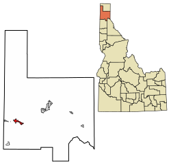
Bonner County Idaho Incorporated and Unincorporated areas Priest River Highlighted 1665530.svg
Location of Priest River in Bonner County, Idaho.
Coordinates: 48°10′56″N116°53′24″W / 48.18222°N 116.89000°W / 48.18222; -116.89000
Country United States
State Idaho
County Bonner
Area
[1]
  Total
3.70 sq mi (9.58 km2)
  Land3.55 sq mi (9.20 km2)
  Water0.14 sq mi (0.37 km2)
Elevation
[2]
2,169 ft (661 m)
Population
 (2010) [3]
  Total
1,751
  Density532.64/sq mi (205.67/km2)
Time zone UTC-8 (Pacific (PST))
  Summer (DST) UTC-7 (PDT)
ZIP code
83856
Area code(s) 208, 986
FIPS code 16-65530
GNIS feature ID2411492 [2]
Website priestriver-id.gov

Priest River is a city in Bonner County, Idaho. The population was 1,696 at the 2020 census, [4] and 1,751 at the 2010 census. [5] Located in the Idaho Panhandle region of the state, the city is at the mouth of the Priest River on the Pend Oreille River.

Contents

Geography

According to the United States Census Bureau, the city has a total area of 3.84 square miles (9.95 km2), of which, 3.69 square miles (9.56 km2) is land and 0.15 square miles (0.39 km2) is water. [6]

Priest River is located on the west bank of the Priest River, which drains Priest Lake 68 miles to the north, where the Priest River joins the much larger Pend Oreille River on its north bank. U.S. Route 2 passes through the town from Sandpoint on the east to Newport and the state of Washington on the west. [7]

It is 7 miles (11 km) east of the border with Washington at Newport, and less than 60 miles (100 km) south (as the crow flies) of British Columbia, Canada.

Climate

According to the Köppen Climate Classification system, Priest River has a warm-summer mediterranean climate, abbreviated "Csb" on climate maps. The hottest temperature recorded in Priest River was 108 °F (42.2 °C) on June 29, 2021, while the coldest temperature recorded was −36 °F (−37.8 °C) on December 30, 1968. [8]

Climate data for Priest River, Idaho, 1991–2020 normals, extremes 1898–present
MonthJanFebMarAprMayJunJulAugSepOctNovDecYear
Record high °F (°C)52
(11)
57
(14)
73
(23)
88
(31)
97
(36)
108
(42)
105
(41)
105
(41)
97
(36)
83
(28)
64
(18)
57
(14)
108
(42)
Mean maximum °F (°C)43.2
(6.2)
47.0
(8.3)
60.3
(15.7)
74.0
(23.3)
84.0
(28.9)
88.7
(31.5)
94.8
(34.9)
95.0
(35.0)
86.4
(30.2)
70.7
(21.5)
51.6
(10.9)
42.6
(5.9)
96.6
(35.9)
Mean daily maximum °F (°C)31.8
(−0.1)
36.8
(2.7)
46.1
(7.8)
56.7
(13.7)
67.9
(19.9)
73.5
(23.1)
83.2
(28.4)
82.9
(28.3)
71.9
(22.2)
54.0
(12.2)
38.4
(3.6)
30.9
(−0.6)
56.2
(13.4)
Daily mean °F (°C)26.9
(−2.8)
29.4
(−1.4)
36.3
(2.4)
44.0
(6.7)
53.3
(11.8)
58.9
(14.9)
65.4
(18.6)
64.3
(17.9)
55.5
(13.1)
43.1
(6.2)
32.7
(0.4)
26.5
(−3.1)
44.7
(7.1)
Mean daily minimum °F (°C)22.1
(−5.5)
22.0
(−5.6)
26.4
(−3.1)
31.2
(−0.4)
38.8
(3.8)
44.2
(6.8)
47.6
(8.7)
45.8
(7.7)
39.0
(3.9)
32.0
(0.0)
27.1
(−2.7)
22.1
(−5.5)
33.2
(0.7)
Mean minimum °F (°C)−0.2
(−17.9)
2.7
(−16.3)
11.0
(−11.7)
21.5
(−5.8)
26.5
(−3.1)
33.5
(0.8)
37.5
(3.1)
35.1
(1.7)
26.5
(−3.1)
17.4
(−8.1)
10.1
(−12.2)
2.8
(−16.2)
−8.0
(−22.2)
Record low °F (°C)−33
(−36)
−35
(−37)
−18
(−28)
−1
(−18)
18
(−8)
24
(−4)
29
(−2)
26
(−3)
16
(−9)
−5
(−21)
−12
(−24)
−36
(−38)
−36
(−38)
Average precipitation inches (mm)3.95
(100)
2.59
(66)
3.40
(86)
2.50
(64)
2.76
(70)
2.61
(66)
0.97
(25)
0.87
(22)
1.30
(33)
2.89
(73)
4.19
(106)
4.53
(115)
32.56
(826)
Average snowfall inches (cm)21.8
(55)
11.3
(29)
5.4
(14)
0.3
(0.76)
0.0
(0.0)
0.0
(0.0)
0.0
(0.0)
0.0
(0.0)
0.0
(0.0)
0.2
(0.51)
9.2
(23)
25.7
(65)
73.9
(187.27)
Average extreme snow depth inches (cm)22.1
(56)
21.1
(54)
17.5
(44)
2.7
(6.9)
0.0
(0.0)
0.0
(0.0)
0.0
(0.0)
0.0
(0.0)
0.0
(0.0)
6.1
(15)
16.0
(41)
22.1
(56)
25.3
(64)
Average precipitation days (≥ 0.01 in)16.412.213.713.012.311.95.65.37.012.015.616.5141.5
Average snowy days (≥ 0.1 in)10.66.43.60.30.00.00.00.00.00.14.711.837.5
Source 1: NOAA [9]
Source 2: National Weather Service [8]

Highways

Demographics

Historical population
CensusPop.Note
1910 248
1920 545119.8%
1930 94974.1%
1940 1,05611.3%
1950 1,59250.8%
1960 1,7499.9%
1970 1,493−14.6%
1980 1,6399.8%
1990 1,560−4.8%
2000 1,75412.4%
2010 1,751−0.2%
2019 (est.)1,893 [10] 8.1%
U.S. Decennial Census [11]

2010 census

As of the census [3] of 2010, there were 1,751 people, 713 households, and 474 families living in the city. The population density was 474.5 inhabitants per square mile (183.2/km2). There were 798 housing units at an average density of 216.3 per square mile (83.5/km2). The racial makeup of the city was 93.3% White, 0.1% African American, 1.1% Native American, 0.6% Asian, 0.2% Pacific Islander, 0.8% from other races, and 3.9% from two or more races. Hispanic or Latino of any race were 2.1% of the population.

There were 713 households, of which 34.5% had children under the age of 18 living with them, 44.5% were married couples living together, 12.2% had a female householder with no husband present, 9.8% had a male householder with no wife present, and 33.5% were non-families. 28.1% of all households were made up of individuals, and 12.7% had someone living alone who was 65 years of age or older. The average household size was 2.45 and the average family size was 2.98.

The median age in the city was 38.1 years. 26.7% of residents were under the age of 18; 8.6% were between the ages of 18 and 24; 23.5% were from 25 to 44; 25.5% were from 45 to 64; and 15.8% were 65 years of age or older. The gender makeup of the city was 49.2% male and 50.8% female.

2000 census

As of the census [12] of 2000, there were 1,754 people, 692 households, and 469 families living in the city. The population density was 1,098.8 inhabitants per square mile (424.2/km2). There were 762 housing units at an average density of 477.4 per square mile (184.3/km2). The racial makeup of the city was 94.70% White, 1.43% Native American, 0.46% Asian, 0.51% from other races, and 2.91% from two or more races. Hispanic or Latino of any race were 1.60% of the population.

There were 692 households, out of which 35.1% had children under the age of 18 living with them, 54.9% were married couples living together, 9.1% had a female householder with no husband present, and 32.2% were non-families. 26.6% of all households were made up of individuals, and 12.4% had someone living alone who was 65 years of age or older. The average household size was 2.53 and the average family size was 3.09.

In the city, the population was spread out, with 28.9% under the age of 18, 8.4% from 18 to 24, 26.6% from 25 to 44, 21.9% from 45 to 64, and 14.1% who were 65 years of age or older. The median age was 35 years. For every 100 females, there were 96.0 males. For every 100 females age 18 and over, there were 93.3 males.

The median income for a household in the city was $26,765, and the median income for a family was $32,198. Males had a median income of $30,607 versus $16,034 for females. The per capita income for the city was $14,125. About 14.0% of families and 18.9% of the population were below the poverty line, including 27.7% of those under age 18 and 9.7% of those age 65 or over.

See also

Related Research Articles

<span class="mw-page-title-main">Clearwater County, Idaho</span> County in Idaho, United States

Clearwater County is a county located in the U.S. state of Idaho. As of the 2020 census, the population was 8,734. The county seat is Orofino. Established in 1911, the county was named after the Clearwater River. The county is home to North Fork of the Clearwater River, and a small portion of the South Fork and the main Clearwater. Also in the county are the Dworshak Reservoir, Dworshak State Park, Dworshak National Fish Hatchery, and the Dworshak Dam, third highest in the U.S. The modest Bald Mountain ski area is located between Orofino and Pierce.

<span class="mw-page-title-main">Bonner County, Idaho</span> County in Idaho, United States

Bonner County is a county in the northern part of the U.S. state of Idaho. As of the 2020 census, the population was 47,110. The county seat and largest city is Sandpoint. Partitioned from Kootenai County and established in 1907, it was named for Edwin L. Bonner, a ferry operator. Bonner County comprises the Sandpoint, Idaho Micropolitan Statistical Area.

<span class="mw-page-title-main">Lava Hot Springs, Idaho</span> City in Bannock County, Idaho, United States

Lava Hot Springs is a city along the Portneuf River in eastern Bannock County, Idaho, United States. It is part of the Pocatello, Idaho metropolitan area. The population was 358 at the 2020 census. Located in the mountainous valley of the Portneuf River on the old route of the Oregon Trail and California Trail, the city has become a popular resort location, noted for its numerous hot springs amenable to bathing and a turbulent inner tube run through part of the town.

<span class="mw-page-title-main">St. Maries, Idaho</span> City in Idaho, United States

St. Maries or Saint Maries is a city in north central Idaho, the largest in rural Benewah County and its county seat. Its population was 2,402 at the 2010 census, down from 2,652 in 2000.

<span class="mw-page-title-main">Carey, Idaho</span> City in Idaho, United States

Carey is a city in Blaine County, Idaho, United States. The population was 604 at the 2010 census. Carey is primarily an agricultural city and is the location of the Blaine County Fairgrounds. Nearby recreational destinations include the Craters of the Moon National Monument, Carey Lake, Silver Creek and the Little Wood River. Further west is the Big Wood River Valley, leading to the Sun Valley resort.

<span class="mw-page-title-main">Clark Fork, Idaho</span> City in Idaho, United States

Clark Fork is a small town in Bonner County, Idaho. The population was 536 at the time of the 2010 census.

<span class="mw-page-title-main">Dover, Idaho</span> City in Idaho, United States

Dover is a city in Bonner County, Idaho. The population was 556 at the 2010 census.

<span class="mw-page-title-main">Hope, Idaho</span> City in Idaho, United States

Hope is a city in Bonner County, Idaho, United States. The population was 86 at the 2010 census.

<span class="mw-page-title-main">Oldtown, Idaho</span> City in Idaho, United States

Oldtown is a city in Bonner County, Idaho and suburb of Newport, Washington, with a population of 184 at the 2010 census. It is located on the Pend Oreille River, just east of Newport. There are no natural or physical barriers, and it is strictly a political division, separated by the straight-line state boundary. Oldtown is squeezed between this boundary to the west and the river to the east, leaving the main business district on U.S. Route 2 with only 700 feet of space in which to operate on the Idaho side. Many homes are located in the south end on the other side of the railroad, as the Pend Oreille is somewhat further away here.

<span class="mw-page-title-main">Bonners Ferry, Idaho</span> City in Idaho

Bonners Ferry is the largest city in and the county seat of Boundary County, Idaho, United States. The population was 2,543 at the 2010 census.

<span class="mw-page-title-main">Moyie Springs, Idaho</span> City in Idaho, United States

Moyie Springs is a city in Boundary County, Idaho, United States. The population was 718 at the 2010 census.

<span class="mw-page-title-main">Arco, Idaho</span> City in Idaho, United States

Arco is a city in Butte County, Idaho, United States. The population was 879 as of the 2020 United States census, down from 995 at the 2010 census. Arco is the county seat and largest city in Butte County.

<span class="mw-page-title-main">Malta, Idaho</span> City in Cassia County, Idaho, United States

Malta is a city in Cassia County, Idaho, United States. The population was 193 at the 2010 census. It is part of the Burley, Idaho Micropolitan Statistical Area.

<span class="mw-page-title-main">Mountain Home, Idaho</span> City in Idaho, United States

Mountain Home is the largest city and county seat of Elmore County, Idaho, United States. The population was 15,979 in the 2020 census. The population in 2024 is projected to be 16,921. It is the principal city of the Mountain Home Micropolitan Statistical Area, which includes Elmore County.

<span class="mw-page-title-main">Preston, Idaho</span> City in Idaho, United States

Preston is a city in Franklin County, Idaho, United States. The population was 5,591 at the 2020 census, up from 5,204 at the 2010 census. The city is the county seat of Franklin County. It is part of the Logan, Utah-Idaho Metropolitan Statistical Area.

<span class="mw-page-title-main">Warm River, Idaho</span> City in Idaho, United States

Warm River is a city in Fremont County, Idaho, United States. The population was 3 at the 2010 census, making it the least populous city in Idaho. It is part of the Rexburg, Idaho Micropolitan Statistical Area.

<span class="mw-page-title-main">Wendell, Idaho</span> City in Idaho, United States

Wendell is a city in southern Gooding County, Idaho, United States. The population was 2,782 at the 2010 census.

<span class="mw-page-title-main">Stites, Idaho</span> City in Idaho, United States

Stites is a city in Idaho County, Idaho, United States. In the lower canyon of the South Fork of the Clearwater River, it is about four miles (6 km) upstream and south of Kooskia on State Highway 13. The population was 221 at the 2010 census, down from 226 in 2000.

<span class="mw-page-title-main">Hazelton, Idaho</span> City in Idaho, United States

Hazelton is a city in Jerome County, Idaho, United States. The population was 807 at the 2020 census. It is part of the Twin Falls, Idaho Micropolitan Statistical Area.

<span class="mw-page-title-main">Dalton Gardens, Idaho</span> City in Kootenai County, Idaho, United States

Dalton Gardens is a city in Kootenai County, Idaho, United States. It is considered a suburb of Coeur d'Alene and borders the city to the north and east. The city of Dalton Gardens is also part of the larger Spokane-Coeur d'Alene Combined Metropolitan Statistical Area which encompasses Kootenai County, Idaho. The population of Dalton Gardens was 2,335 at the time of the 2010 census.

References

  1. "2019 U.S. Gazetteer Files". United States Census Bureau. Retrieved July 9, 2020.
  2. 1 2 U.S. Geological Survey Geographic Names Information System: Priest River, Idaho
  3. 1 2 "U.S. Census website". United States Census Bureau . Retrieved December 18, 2012.
  4. "Explore Census Data". data.census.gov. Retrieved May 23, 2024.
  5. Spokesman-Review Archived 2016-03-04 at the Wayback Machine - 2010 census - Priest River, Idaho - accessed 2011-12-13
  6. "US Gazetteer files 2010". United States Census Bureau. Archived from the original on July 2, 2012. Retrieved December 18, 2012.
  7. "Priest River Quadrangle". usgs.gov. U.S. Geological Survey. Retrieved May 1, 2022.
  8. 1 2 "NOAA Online Weather Data – NWS Spokane". National Weather Service. Retrieved November 10, 2023.
  9. "U.S. Climate Normals Quick Access – Station: Priest RVR EXP STN, ID". National Oceanic and Atmospheric Administration. Retrieved November 10, 2023.
  10. "Population and Housing Unit Estimates". United States Census Bureau. May 24, 2020. Retrieved May 27, 2020.
  11. "Census of Population and Housing". Census.gov. Retrieved June 4, 2015.
  12. "U.S. Census website". United States Census Bureau . Retrieved January 31, 2008.