Pulpatta

Last updated

Pulpatta
village
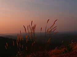
Valamangalam Pulpetta (386717435).jpg
Valamangalam, Pulpetta
Coordinates: 11°09′04″N76°04′01″E / 11.15112°N 76.06693°E / 11.15112; 76.06693 Coordinates: 11°09′04″N76°04′01″E / 11.15112°N 76.06693°E / 11.15112; 76.06693
CountryFlag of India.svg  India
State Kerala
District Malappuram
Population
 (2001)
  Total35,093
Languages
  Official Malayalam, English
Time zone UTC+5:30 (IST)
PIN
676123
Vehicle registration KL-

Pulpatta or Pulpetta is a village in Eranad Taluk, Malappuram district in the state of Kerala, India. [1] It is located 7 km away from Manjeri.

Contents

Location

Pulpatta is located on the northern side of Mongam, Valluvambram and Manjeri in Malappuram District, India. Actually pulpatta is located in manjeri - kizhissery road

Demographics

As of 2011 India census, Pulpatta had a population of 42683 of which 21151 are males while 21532 are females. [2] [1]

Transportation

Pulpatta village connects to other parts of India through Manjeri town. National highway No.66 passes through Parappanangadi and the northern stretch connects to Goa and Mumbai. The southern stretch connects to Cochin and Trivandrum. National Highway No.966 connects to Palakkad and Coimbatore. The nearest airport is at Kozhikode. The nearest major railway station is at Tirur.

Related Research Articles

Muttippalam is a small town near Manjeri in the Malappuram District of Kerala in India. It is on the Manjeri–Malappuram road, about 3 km away from Manjeri.

Mankada Village in Kerala, India

Mankada is a hillside village in the Malappuram district of Kerala state. It is located 15 km (9.3 mi) from Malappuram and is part of the Malappuram parliament constituency. The municipal town of Perinthalmanna is just 10 km (6.2 mi) away. Also, the municipal towns of Manjeri and Malappuram are just 15 km (9.3 mi) away. Mankada Kadannamanna Kovilakam was the seat of ruling family of the erstwhile Kingdom of Valluvanad.

Mampad Town in Kerala, India

Mampad is a growing town in Malappuram district, Kerala, India. located about 08 km east of Nilambur city. Nearby places include Edavanna, Areacode, Manjeri, Wandoor and Pandikkad. It is under the Wandoor Assembly Constituency. Kozhikode-Nilambur-Gudalur SH pass through here. The Mampad town is now developing day to day. Most people are engaged in agriculture and business activities. Hindus, Christians and Muslims co-exist in harmony adding to the diversity in faith and religion. The land is famous for football. The land where Asif Zahir Mampad Rahman played. He contributed a lot to the Malappuram district.

Edayoor is an Indian village.

Elankur is a village in Trikkalangode Grama Panchayat in Malappuram district in the state of Kerala, India near Manjeri. Most of the people in this village are farmers involved in rice cultivation.

Keezhattur Village in Kerala, India

Keezhattur is a village in Malappuram district in the state of Kerala, India. Poonthanam illam, the birthplace of "bhakthakavi" Poonthanam namboothiri, famous ancient Malayalam poet, is located here. The poonthanam illam is now a popular cultural centre. Keezhattur is a moderately large panchayat.The major place in keezhattur panchayat is kizhattur.'kizhattur pooram' is the major festival in keezhattur. Its administrative offices are located in Akkaparambu, which is about 12 km away from Perinthalmanna, the largest city of Malappuram district.

Trikkalangode Place in Kerala, India

Trikkalangode is a large Grama Panchayath located in Ernad (Manjeri) Taluk of Malappuram district in Kerala state with total 10415 families residing. The Trikkalangode Grama Panchayath has population of 52090 of which 25140 are males while 26950 are females as per Population Census 2011. In Trikkalangode village population of children with age 0-6 is 7266. Average Sex Ratio of Trikkalangode is 1046 which is lower than Kerala state average of 1084. Child Sex Ratio for the Trikkalangode as per census is 927, lower than Kerala average of 964.

Triprangode Village in Kerala, India

Triprangode is a village in Malappuram district in the state of Kerala, India. As of 2001 India census, Triprangode had a population of 37175 with 17422 males and 19753 females. Three sides of the village is surrounded by water bodies.

Urangattiri is a village in Malappuram district in the state of Kerala, India. It is situated in the valley of Chaliyar. There are 21 wards in this village.

Vadakkangara is a village in Malappuram district in the state of Kerala, India.

Vettikkattiri is a village in Malappuram district in the state of Kerala, India.

Cherani is a location in Manjeri Municipality in Malappuram district of Kerala state of South India.

Thanippara is a location in Manjeri Municipality in Malappuram district of Kerala State of south India.

Vayapparappadi is a location in Manjeri Municipality in Malappuram district of Kerala State of south India.

Santhigram is a location in Manjeri municipality in Malappuram district of Kerala State of south India.

Mullampara is a town located in the Manjeri Municipality in the Malappuram district of the Indian state of Kerala.

Payyanad is a place located in Manjeri municipality of Malappuram district of Kerala. Payyanad football stadium located in Payyanad

Porur is a small village in Malappuram district, Kerala, India. Manjeri also is a nearby town.

Konikkallu is a village in Anakkayam Panchayat, Eranad Taluk, Malappuram district, Kerala state, India.

Eranad Taluk Taluk in Kerala, India

Eranad Taluk comes under Perinthalmanna revenue division in Malappuram district of Kerala, India. Its headquarters is the city of Manjeri. Eranad Taluk contains two municipalities - Manjeri and Malappuram. Most of the administrative offices are located in the Civil Station at Malappuram and the Mini-Civil Station at Manjeri.

References

  1. 1 2 Registrar General & Census Commissioner, India (ed.). "Census of India : Villages with population 5000 & above" . Retrieved 10 December 2008.
  2. "Pulpatta Village Population - Ernad - Malappuram, Kerala".