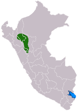
The Chachapoyas, also called the "Warriors of the Clouds", was a culture of the Andes living in the cloud forests of the southern part of the Department of Amazonas of present-day Peru. The Inca Empire conquered their civilization shortly before the Spanish conquest in the 16th century. At the time of the arrival of the conquistadors, the Chachapoyas were one of the many nations ruled by the Incas, although their incorporation had been difficult due to their constant resistance to Inca troops.

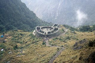
Llaqtapata (Quechua) llaqta place, pata elevated place / above, at the top / edge, bank, shore, pronounced 'yakta-pahta', Hispanicized Llactapata) is an archaeological site about 5 km (3.1 mi) east of Machu Picchu. The complex is located in the Cusco Region, La Convención Province, Santa Teresa District, high on a ridge between the Ahobamba and Santa Teresa drainages.

Chachapoyas is a province of the Amazonas Region, Peru. The province of Chachapoyas was a part of the department of Trujillo being its capital the city of Chachapoyas.

Tambomachay is an archaeological site associated with the Inca Empire, located near Cusco, Peru. An alternate Spanish name is El Baño del Inca.

Patallacta, Llactapata or Q'ente Marka is an archaeological site in Peru located in the Cusco Region, Urubamba Province, Machupicchu District. It is situated southeast of the site Machu Picchu, at the confluence of the rivers Cusichaca and Vilcanota on a mountain named Patallacta.

Intihuatana at the archaeological site of Machu Picchu is a notable ritual stone associated with the astronomic clock or calendar of the Inca in South America. Machu Picchu was thought to have been built c. 1450 by the Sapa Inca Pachacuti as a country estate. In the late 16th century, the Viceroy Francisco de Toledo and the clergy destroyed those Intihuatana which they could find. They did so as they believed that the Incas' religion was a blasphemy and the religious significance of the Intihuatana could be a political liability. The Intihuatana of Machu Picchu was found intact by Bingham in 1911, indicating that the Spanish conquerors had not found it. Intihuatana was damaged on September 8, 2000 when a crane being used in an ad shoot toppled over and chipped off a piece of the granite.

Incahuasi or Incawasi is an archaeological site in Peru. It is located in the Lima Region, Cañete Province, Lunahuaná District.
Runkuraqay or Runku Raqay is an archaeological site on a mountain of the same name in Peru located in the Cusco Region, Urubamba Province, Machupicchu District. It is situated southeast of the archaeological site Machu Picchu and south of the Vilcanota river. The ruins lie on the southern slope of the mountain Runkuraqay near the Runkuraqay pass, northeast of the archaeological site Sayacmarca and southeast of the site Qunchamarka.

Mawk'allaqta or Mawk'a Llaqta is an archaeological site in Peru. It is located in the Cusco Region, Paruro Province, Paccaritambo District, near Mullipampa (Mollebamba).
Inkilltambo,Inquilltambo,Inquiltambo or Inkill Tampu is an archaeological site in Peru. It is situated in the Cusco Region, Cusco Province, San Sebastián District.

Machu Colca, Machuqolqa or Machu Qollqa is an archaeological site in Peru. It lies in the Cusco Region, Urubamba Province, Huayllabamba District, a few minutes outside of Chinchero. Machu Colca is situated at about 3,850 metres (12,631 ft) of elevation, above the left bank of the Urubamba River, near the village of Raqch'i (Raqchi).
Machu Q'inti is an archaeological site in Peru. It is situated in the Cusco Region, Urubamba Province, Machupicchu District. Machu Q'inti is situated above the left bank of the Willkanuta River, near the archaeological sites of Wayna Q'inti, Willkaraqay and Patallaqta which is also named Q'inti Marka.
Wayna Q'inti is an archaeological site in Peru. It is situated in the Cusco Region, Urubamba Province, Machupicchu District. Wayna Q'inti is situated above the left bank of the Willkanuta River, near the archaeological sites of Machu Q'inti, Willkaraqay and Patallaqta which is also named Q'inti Marka.
T'uqu T'uquyuq or Machu Machuyuq is an archaeological site with rock paintings in Peru. It is situated in the Cusco Region, Urubamba Province, Yucay District. The site lies at a height of about 3,150 metres (10,335 ft) on the slopes of the mountain Saywa (Sayhua).

Wayna Tawqaray is an archaeological site in Peru. It is located in the Cusco Region, Cusco Province, San Sebastián District, about 5 km southeast of the center of Cusco. Wayna Tawqaray is situated at a height of about 3,600 metres (11,811 ft) on the slope of the mountain Tawqaray (Taucaray). The mountain with the archaeological remains lies southeast of the mountain Araway Qhata and the hill Muyu Urqu, above the river Watanay.
Cochabamba is an archaeological site of the Inca period in Peru. It is situated in the Amazonas Region, Chachapoyas Province, Chuquibamba District, near the village of Chuquibamba.
Wilca is an archaeological site in Peru. It is situated in the Amazonas Region, Utcubamba Province, in the east of the Cajaruro District, near the border with the Bongara Province.
Machu Pirqa is an archaeological site of the Chachapoyas culture in Peru. It is located in the Amazonas Region, Chachapoyas Province, Magdalena District. Machu Pirqa is situated at a height of about 1,900 metres (6,234 ft) on the left bank of the river Kuntichaka (Condechaca), an affluent of the Utcubamba River.

Purunllacta or Purum Llacta (possibly from Quechua purum, purun savage, wild / wasteland, llaqta place is an archaeological site in Peru. It is situated in the Amazonas Region, Chachapoyas Province, Soloco District, southwest and near the archaeological site of Purum Llaqta of the Cheto District.

Inti Watana or Intiwatana (Quechua) is an archaeological site in Peru. It lies in the Cusco Region, Calca Province, Pisac District.
